Friday, August 1, 2003
 After taking a good look at Burney Falls, I hiked up to Rock Creek and took a dip. It was just the right thing after a long, hot ascent. I met Connie and Terry setting up their camp at Peavine Creek. When I introduced myself as Dan, Terry shot back my last name and the details of my trip, one of my web fans! It began to rain during that conversation, at about a quarter of six, not to stop for about forty hours. (Dan)
Camp: 1 mile past the bog beyond Red Mountain
Miles Walked: 17
Friday, August 1, 2003
The webmaster received another 128 Mb digital camera memory chip full of photos, and a digital sound recorder, to download. (Webmaster Gene)
Saturday, August 2, 2003
There was light rain all day, and all night. A deer walked right up to me before realizing what he was doing, then bolted off into the woods. I saw no one all day. (Dan)
Camp: 2 miles past Deer Creek
Miles Walked: 28
Sunday, August 3, 2003
With a little sun around 11 am, I laid my gear out to dry. Rain continued off and on all day. There was awesome noise of crashing thunder all evening, but I saw only one flash of lightning. There was no rain overnight. (Dan)
Camp: Closed road about .9 miles past Squaw Valley Creek
Miles Walked: 23
 Monday, August 4, 2003
A misty morning gave way to full sun by 9 am. I laid my gear out again for more drying. At my resupply at Ammarati's Market, they had only 4-packs of toilet paper, so I gave the other 3 rolls to a logging crew stopping in for beer, cigarettes, etc. When they left, they said "Thanks for the Mountain Money." It's funny, but I guess if you had TP, and the guy who needed it didn't, you could buy about whatever you wanted with it. I walked up Bob's Hat Trail and camped at the PCT crossing of Indian Creek. (Dan)
Camp: Indian Creek
Miles Walked: 20
Monday, August 4, 2003
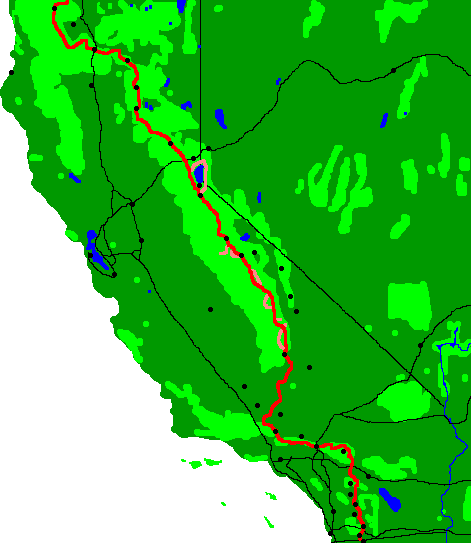
Dan called from Castle Craggs State Park, where the PCT crosses I-5 at Dunsmuir. (PCT Mile 1500.4). He had finished 1500 miles, which was over half the through hike: A very proud accomplishment. The next place where he could call from was eight days away at Seiad Valley, CA (PCT Mile 1657.0). He planned on taking a short layover when he reached Ashland Oregon (PCT Mile 1721.5) which was about 11 days away. The Ashland Post Office is a PCT hiker mail delivery location and the webmaster planned to return the digital camera memory chips and sound recorder to him there. Dan had had some rain from Burney Falls until Sunday, which brought the temperature down a bit but made the trail muddy in spots. (Webmaster Gene)
Tuesday, August 5, 2003
It was a very cool, overcast morning. When I saw a rattlesnake, he was quite lethargic and sloppy about hiding. As he slowly crawled under a rock, I counted 12 rattle segments. He never disappeared completely, the last 10 inches of his tail were still in view when I got bored and went away. There were awesome views of the Castle Craggs and Mount Shasta. I took a dinner break, and later camped, with Dutch Apple Pie and her mom. (Dan)
Camp: 1/4 mile past road 40N45
Miles Walked: 22

|

|
Wednesday, August 6, 2003
I found a then rare patch of snow by the trail. I met Cat McAdams who gave me a great peach. In marshy areas here I found some insect eating Cobra Lily plants Darlingtonia Californica - kind of like pitcher plants I saw later in the Okefenokee Swamp. (Dan)
Camp: Little Trinity River and Sisson Trails
Miles Walked: 24

|

|
Thursday, August 7, 2003
Camp: .7 miles north of the Eagle Creek/Bloody Run Trail intersection
Miles Walked: 22

|

|
 I camped just shy of Payne's Lake. My bear rope tangled in a tree. Try as I might, I could not get it down. (Dan)
Saturday, August 9, 2003
With better light in the morning, I figured out a rhythm I could use to get the bear rope to untangle. I swam with the salamanders in Fisher Lake. The salamanders were jumping from the lake for flies. I camped one and a quarter miles past Marten Lake. The camp was trashed, with dozens of eggshells, several barbecue grills, a cookie sheet, pot scrubbers, etcetera, strewn about the camp. That was too bad, because the scenery was hauntingly beautiful. There were dozens of springs supporting lush plant life at the base of a craggy cliff, and wonderful views of Mount Shasta and the surrounding hills. (Dan)
Camp: 1 1/4 miles past Marten Lake
Miles Walked: 21

 Sunday, August 10, 2003
When I untied the bear rope in the morning, the food bag stuck in the tree, causing a momentary fit of fear considering my recent episode. But it broke free easily. 3 turkeys flushed out and took off as I hiked along. I took a swim with the frogs and salamanders in Paradise Lake. I camped with Bandana and Ninja Rob 3 miles out of the Marble Mountain Wilderness. (Dan)
Camp: 3 miles past the Marble Mountain Wilderness
Miles Walked: 23
Monday, August 11, 2003
I walked 17 miles into Seiad Valley by 2pm. I planned to hike on after resupply, shower and laundry, but was sucked in by a nice bunk at the Mid River RV Park. (Dan)
Camp: Mid River RV Park
Miles Walked: 17
Monday, August 11, 2003
Dan called from Seiad Valley, where the PCT crosses Highway 96 (PCT Mile 1657.0). The weather was cooler and drier than in San Diego (95°F). This town has a post office, where he mailed some items to me, a store, where he resupplied, and a Laundromat, where he washed his clothes. There is a cafe there, where if you can eat 5 pounds of pancakes, the meal is free. Dan didn't partake in this. He ate a lot of carbohydrate filled food while on the trail and he wanted some nutritional food when he could get it. Since he had used practically all the facilities this town had to offer, he planned to get back on the trail and hike a few more miles before stopping to camp.
He had only 1001.7 miles left to the end of the PCT at the Canadian border. He was averaging 22 to 23 miles a day, and expected to be in Ashland Oregon in three days (August 14). He planned on celebrating crossing his first state line by taking a day off from the trail in Ashland. If he found somewhere to access the internet, he planned to update his trail log. (Webmaster Gene)
Tuesday, August 12, 2003
I went to breakfast early in the morning, again thinking of an early start. But all morning, through hikers (Ninja Rob, Bandana, Prune Pirate, Navigator, Kimber, Yucca, & The One) kept pouring out of the woods, so I stayed to chat at breakfast until after 10. There were no pancake challengers. High, wispy clouds covered 2% of the sky. (Dan)
Camp: 1/4 mile past the Copper Butte Trail 11W02
Miles Walked: 18
Wednesday, August 13, 2003
 There were a few puffy clouds, but it was generally warm and sunny all day. I saw no one else. Crossing into Oregon was great, one state down, two to go. (Dan)
Camp: Wrangle Gap
Miles Walked: 25
 Thursday, August 14, 2003
Long, stringy clouds were forming over Shasta and trailing north. Contrails lingered. In the afternoon, clouds began filling the rest of the sky. I got into Ashland in the afternoon, and stayed at the Columbia Hotel. (Dan)
Hotel: Columbia Hotel
Miles Walked: 21
Thursday, August 14, 2003
I received the package Dan sent from Seiad Valley. He sent another disk of photos and some items from the trail: A (hawk?) feather, a stone that looked like petrified wood, a colorful snail shell which didn't survive the USPS handling, and two pages from his trail guide book which he removed as he completed the section of trail that the page covers. One of the pages was "Section Q: Etna Summit to Seiad Valley". The other page was the trail-worn back cover of the book.
Dan called from Ashland Oregon. He hoped to update his trail journal when he found a computer. There was no place to access the internet from Truckee to Ashland, so he had a lot of typing to do. (Webmaster Gene)
Friday, August 15, 2003
I moved to the Ashland Hostel and saw the movie "Swimming Pool". This was an intellectual twister: every hiker who saw it figured it out differently. So they asked me, hoping I would support one of their versions, but I had yet another opinion.(Dan)
Hostel: Ashland Hostel
Miles Walked: 3
Saturday, August 16, 2003
 I got a free haircut and 3 free pound cakes on my way out of Ashland. Hitchhiking out to the trail, my big soda bumped my ride's car and made a big mess. A rattlesnake started buzzing off to the side of the trail. Free Radical and I would never have seen him in the grass, but we followed the rattling and took some pictures. We laughed a lot when he backed away from us up onto a 2 foot diameter log and then fell off the back. He was REALLY mad then. We hiked to the west flank of Little Pilot Peak and camped with a great view of the sunset and the lights of Ashland. (Dan)
Camp: West flank of Little Pilot Peak
Miles Walked: 6
Sunday, August 17, 2003
I saw an osprey at Hyatt Lake and lots of 3/4 inch frogs later. (Dan)
Camp: Wildcat Overlook
Miles Walked: 19

|

|
Monday, August 18, 2003
I found a Widmer Hefeweisen in a tree while walking on Dead Indian Road to Lake of the Woods. (Dan)
Camp: Lake of the Woods
Miles Walked: 29
Tuesday, August 19, 2003
We walked along the Cascade Canal to Fourmile Lake, where we saw an osprey and an eagle fighting in the sky. (Dan)
Camp: 1 mile past the Badger Lake / Red Lake Trail junction
Miles Walked: 15

|

|
Wednesday, August 20, 2003
 We took the Sky Lake Trail alternate up to the Devil's/Lee Peak Saddle, it was beautiful. We camped in the "Oregon Desert", actually a very nice forest. There was lots of elk scat there. (Dan)
Camp: Oregon Desert
Miles Walked: 22
Thursday, August 21, 2003
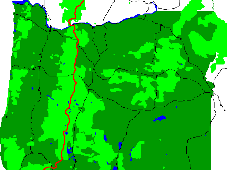
Dan called from Mazama Campground in Crater Lake National Park (PCT Mile 1825.3). Free Radical was hiking with him for this section, and they planned on hiking around the park for a couple of days. Friday, they would hike the eight miles of road to town, then head around the lake and toward Diamond Lake and Mount Theilsen.
The Willamette National Forest had closed the entire Mt. Jefferson Wilderness Area west of the Cascade Ridge line due to potential danger from the Booth and Bear Butte Fires. They also closed the Pacific Crest Trail through the Mt. Washington Wilderness, and offered shuttle service to through-hikers going both north and south. The fires were about a week north of Dan's location. (Webmaster Gene)
 Thursday, August 21, 2003
We hiked into the Mazama Campground in Crater Lake National Park in occasional rain, and got into a hotel room there to stay dry. The hotel room was split between maybe a dozen hikers. I got the first shower, and it felt great to be clean. Then I opened the bathroom door, and the stench of the other hikers was astounding. I handn't even noticed it before my shower. I guess that showed me what I smelled like on the trail. The rained poured down all night, and in the morning, the Mazama campground guests were miserable and fighting for the dryers in the laundry room. (Dan)
Hotel: Mazama Campground Motel
Miles Walked: 15
Friday, August 22, 2003
We hiked to the Crater Lake rim via the Annie Spring, PCT, and Dutton Creek Trails. There we hung out with Prune Pirate as other through hikers showed up through the day. There was occasional rain all day. We went 60 miles off route to Klamath Falls with One Breath and his mom, and set up camp in the Holiday Inn Express.
The newspapers had similar fire info to that discussed yesterday. Precisely, the PCT was closed from Highway 242, McKenzie Pass, to Clakamas Lake, 92.7 miles.  Luckily, the dark clouds and rain seemed concentrated in the north, perhaps the fires would be rained out by the time we got there. But the newspapers showed the weather would clear soon. We would be playing it by ear. (Dan)
Hotel: Klamath Falls (far off the PCT)
Miles Walked: 9
Saturday, August 23, 2003
One Breath, his mom, Free Radical, and I drove around the rim of Crater Lake and then Free Radical and I hiked around the rim to just where the trail starts heading north away from the lake. On the way, we climbed to the fire lookout. (Dan)
Camp: North Rim of Crater Lake
Miles Walked: 7

|

|
Sunday, August 24, 2003
Free Radical and I had arranged while at Crater lake to have water dropped off for us near Highway 138, since that section has few water sources. But at least one other hiker was jealous of our stash! We hiked to Diamond Lake, where firefighters told us the B&B fire was raging (But they were working a local fire.). We stayed at the resort motel. (Dan)
Hotel: Diamond Lake
Miles Walked: 30
 Monday, August 25, 2003
I camped at Maidu Lake with Free Radical, Bandana, Lugnut, Teatree, The One, Ninja Rob, Secret Agent, and the Northerner. (Dan)
Camp: Maidu Lake
Miles Walked: 13
Tuesday, August 26, 2003
I left Free Radical with the F Troop and camped 4 miles past White Fish Horse Camp. (Dan)
Camp: 4 miles past White Fish Horse Camp
Miles Walked: 25
Wednesday, August 27, 2003
 Dan called from Odell Lake, near Highway 58 at Willamette Pass, at the Shelter Cove Resort (Shelter Cove is at PCT Mile 1907.1). He passed the 1900 mile mark that morning; 71% of the trail was behind him and he had only 28% to go. According to Dan and the latest fire update, the PCT was closed from Hwy 242 at McKenzie Pass north to Olallie Lake. McKenzie Pass is 78 miles from where Dan was (3 to 4 days). I asked him what his plans were and he said "I really don't know." For years, Engineer Dan has had to make snap decisions based on sketchy information. I guess this is no exception.
Wednesday, August 27, 2003
I had pizza at the Willamette Pass Ski Resort. (Dan)
Camp: a few miles past Rosary Lakes
Miles Walked: 18
Thursday, August 28, 2003
While having lunch with the F Troop at Charleton Lake, we got a great talk on forest fires from a firefighter out trying to catch people for illegal campfires. (Dan)
Camp: pond SSE of Stormy Lake
Miles Walked: 21

|

|
 Friday, August 29, 2003
I saw a terrestrial garter snake and found a Swiss Army Knife after a breakfast of Fritos and raisins at Tadpole Lake. Later, at a lunch break with F-Troop at Cliff Lake, I was swimming when a bat flew by, odd for the middle of the day. There was lots of haze and smoke smell in the afternoon blowing south from the B&B Complex Fire. (Dan)
Camp: just beyond the Nash Lake Trail junction
Miles Walked: 25
Saturday, August 30, 2003
 The trail was closed for the B&B Fire beyond the Lava Camp Trail, so I hiked out that to the highway. There was ash floating in the air, the sun was dimmed orange, and shadows were fuzzy from the haze. Chance, Teatree, Special Agent, and I hitched into Bend and stayed at the Best Western. (Dan)
Hotel: Best Western in Bend, Oregon
Miles Walked: 23
Sunday, August 31, 2003
Dan called from Government Camp, on State Highway 26. The PCT was closed south of Highway 242, so he took the Lava Camp Trail from the PCT (at PCT Mile 1983.1) to Highway 242, where he caught a ride to Bend, Oregon. He stayed overnight at Bend, then caught a Greyhound Bus to Government Camp, which is north of Olallie Lake. He was thinking about hiking north on the PCT, from here (Government Camp - PCT Mile 2097.0) to Canada, then taking the bus back to here and finishing the 114 mile section he missed by hiking south. Hopefully the fires would be burned out by then. (Webmaster Gene)
Sunday, August 31, 2003
I took the Greyhound Bus from Bend to Government Camp, resupplied, walked up the ski resort runs to the Timberline Lodge, and got a pizza in the bar. I camped in Paradise Park on the west flank of Mount Hood with dozens of other campers. I was supposed to hook up with some other throughhikers, but there were so many people camped there, I couldn't find them. (Dan)
Camp: Paradise Park
Miles Walked: 13