
Deer Hoof
Summary
Although I generally followed the PCT, I took a number of parallel routes. To date, I have not accumulated enough maps to follow a largely off PCT route, so I took notes on potential side trails and maps. Still, I had not been on this PCT section for 12 years: I remembered towns and outstanding views, but nothing about the day to day hiking. So repeating the trail didn't bore me. And I enjoyed the company of the PCT crowd.
I made an abnormally high number of town stops so I could stay in touch with my parents, but I usually had a meal, resupplied, and returned to the trail fairly quickly.
Beyond the Castella area, all the way across Oregon, there was almost always a lot of smoke from wildfires. A few hikers had trouble breathing, but I mostly missed the great views I had seen in 2003.
Friday, July 3, 2015
After meeting so few people on my back routes, it was fun to talk to many PCTers after Glen Aulin. I even camped and enjoyed a fire with several. One thing I've missed on this trip is the comaraderie between long distance hikers. I had one turd that had remnants of red but was mostly normally colored.
Miles: 16 317
Camp: Spiller Creek
Maps: NGTI206
Route: McGee Lake, PCT
Saturday, July 4, 2015
There were occasional short rainshowers. I swam twice. My diarrhea issue seems to be a thing of the past. The blood never seems to have been black or like coffee grounds, so it likely came from the lower intestinal tract. The appearance was like raspberry or strawberry jam in color and texture, but less viscous, like syrup or motor oil.
Miles: 16 333
Camp: After the Benson Lake Junction
Maps: NGTI206
Route: PCT
Sunday, July 5, 2015
I swam a couple of times and improved a log walk ford. I had several nice conversations with PCTers. One gal said her solar charger could half charge a smart phone after charging all day atop her pack. Performance seemed better at higher altitudes. Goal Zero brand chargers seemed to have adequate reliability, whereas some other brands seemed to fail earlier on the trail. I saw some Yellow Bellied Marmots, and some trout.
Miles: 14 347
Camp: Wilmer/Wilma? Lake
Maps: NGTI206
Route: PCT
Brannigan / Wilmer / Wilma Lake
I noticed that some signs and some maps refer to this lake as Wilma and others as Wilmer. A 2013 internet piece by Alex Wierbinski explains the conflict. In 1894 Lt. McClure named the lake after Brannigan, a member of his party, while exploring Yosemite. Maps up to 1911 show the lake named as Brannigan. After 1912, the lake was renamed Wilmer by R. B. Marshall, of the USGS for "Wilmer Seavey, daughter of Clyde L. Seavey." Maps showed Wilmer Lake until the 1956 revised USGS Tower Peak 7½' quadrangle. The daughter had protested that her name was Wilma, not Wilmer. The flame cut steel signs in Yosemite were installed in the 1950s, and probably won't need replacing for many years...
Monday, July 6, 2015
I left the PCT to walk through the Emigrant Wilderness to the northern Kennedy Meadows Resort. I feel I'm more fatigued and slower than I ought to be, so maybe some serious calories and an easy day tomorrow are in order. I've visited the Emigrant twice before, once with Jim, and once with my brother and dad when my brother was still at UC Berkely, long ago. On that trip, we put out a smoldering, spreading duff fire. We had also seen a fully equipped smoke jumper hiking out barefoot, and, ironically, had on the drive up discussed how people can still be compelled to fight forest fires if the manpower need exists. I saw a Mule Deer, some Marmots, and some trout. There is a Montezuma Mine and associated ruins near Bond Pass. The trails between Bond and Emigrant Passes were once very good dirt roads, with culverts, blasted beds, etcetera. A hiker with a no name solar charger was also happy with the reliability.
Miles: 17 364
Camp: Summit Creek
Maps: NGTI206, 807
Route: PCT, Bond Pass, Brown Bear Pass
| Emigrant Wilderness Mines | ||||||||||||||||||||||||||
|---|---|---|---|---|---|---|---|---|---|---|---|---|---|---|---|---|---|---|---|---|---|---|---|---|---|---|
|
The PCT crosses north out of Yosemite NP into Humboldt Toiyabe NF at Dorothy Lake Pass. To the West is the Emigrant Wilderness. Hikers wishing to resupply at the northern of the two Kennedy Meadows could walk there across the Emigrant Wilderness / Basin. The Basin contains many glacially carved granite canyons with rolling ridges, making some cross country walking easy and fun. Many lakes are shallow, island dotted, and pretty. Some lakes have low dams to retain snowmelt through the summer and stabilize streamflow. Perhaps 30 - 50 miles west of the basin were rich placer (streambed gravel) and lode (hard rock) gold deposits which fueled the middle 1800s California Gold Rush. East of the Sierras is the gold mining ghost town of Bodie. Silver Mine Creek, which flows into Relief Reservoir, had a now buried siver mine. But gold and silver, while present, are not sufficient in concentration to attract much mining in the basin. North of the wilderness along road 5N01 and Niagara Creek, are uranium works including the Juniper Mine. (The road also approaches the aforementioned silver mine.) In the 1960s, thousands of tons of U3O8 ore were shipped to Salt Lake City, which made the Juniper the biggest Uranium mine in California. Tungsten is the only mineral to have been commercially produced in the Emigrant Basin. A road left Highway 108 at Leavitt Creek and perhaps roughly followed the PCT up Kennedy Creek, then following the crest south to the Monezuma and eventually Cherry Mines. The roads were in great shape and made easy hiking trails in 2015. The Montezuma Mine and its associated ruins were just to the south of my route west from Bond Pass. The Dorothy Number 1 Mine was just outside the southeast corner of the basin, and produced 55 tons of 70% WO3 in 1943 (Packed out by mule). However, the ore body was small and was quickly exhausted.
Map NGTI807
| ||||||||||||||||||||||||||
Tuesday, July 7, 2015
I had been building a powerful hunger, and satisfied it with breakfast, lunch, and dinner. I shipped home maps, a bear barrel, and my my big camera, two lenses, etcetera. I hadn't been much inspired to use it anyway. A $35 deal on a bed, laundry, and shower was sweet.
Miles: 8 372
Camp: Kennedy Meadows Bunkroom
Maps: NGTI807
Route: Saucer Meadow, Relief Reservoir, 20e11
Deer Hoof
Wednesday, July 8, 2015
A guy was selling resupply items at pretty good prices at Sonora Pass. It began to rain, hail, and thunder, and continued through the day.
Miles: 9 381
Camp: On Ascent from East Fork Carson River
Maps: NGTI807
Route: PCT
Thursday, July 9, 2015
Rain, hail, and thunder continued through the morning, stopped a few hours, and returned around 3:30.
Miles: 11 381
Camp: Headwaters of Wolf Creek
Maps: NGTI807
Route: PCT
Friday, July 10, 2015
Very little rain fell, but bitter cold conditions continued. I hiked in full fleece and rain pants at a minimum. The screen of my tablet computer cracked, but was still useable.
Miles: 14 395
Camp: Pennsylvania Creek
Maps: NGTI807
Route: PCT
Big Tree Road (1856)
The PCT crosses the Big Tree Road near Ebbetts Pass. Roughly present day Highway 4, it passes the Calaveras Big Trees, Murphys, Angels Camp (Mark Twain's Jumping Frog Contest), and ends at Stockton.
Saturday, July 11, 2015
No rain, but cold wind and a few clouds continued. I was able to spread and dry my gear. I'm not sure why I'm going so slow on the PCT. I'm often tired and out of breath. It seems strange given how long I've been out.
Miles: 16 411
Camp: Lost Lakes
Maps: NGTI807
Route: PCT
|
Carson Pass In February 1844, John C. Fr�mont's Expedition crossed this pass from the Great Basin to California. Washoe Indians had told them about the pass but had warned that the deep snow would make passage all but impossible in winter. On February 14, Fr�mont ignored that advice, and ascended with cartographer Charles Preuss to Red Lake Peak, becoming the first white men to see Lake Tahoe. By March 6, they made it to Sutter's Fort. Christopher Houston "Kit" Carson (December 24, 1809 � May 23, 1868) was one of the fur trapping mountain men who eventually gained great fame as guides, explorers, and military men. In the 1840s, he and Preuss accompanied Fr�mont on expeditions exploring the Oregon Trail, Oregon, California, and the Great Basin. Kit guided the parties. George Karl Ludwig "Charles" Preuss (1803-1854) made the first accurate, detailed maps of the Oregon Trail, Oregon, California, and the Great Basin. His maps and notes on the Oregon trail were critical to settlers following the Platte River route. John Charles Fr�mont (January 21, 1813 � July 13, 1890) was the Army leader of these exploratory parties. The first expedition, involving 25 men, in 1842 exploring the Oregon Trail from the Missouri River to South Pass, Wyoming (discovered by Jedediah Smith) (near the CDT), resulted in the report; A Report on an Exploration of the Country Lying between the Missouri River and the Rocky Mountains on the Line of the Kansas and Great Platte Rivers, published widely in newspapers. The second party, in 1843, continued west from South Passalong the Oregon Trail to the Columbia River. Rather than follow the Columbia to the Pacific Ocean, they headed south, crossing westbound over the pass they named after Carson. Later, they crossed Tehachapi Pass, west of the PCT, before returning east via South Pass. Fr�mont concluded that the Great Basin had no outlet to the oceans, and his "Report and Map" were published by the US Congress. The third and fourth expeditions were on the eastern slope of the Rockies, looking for rail routes. On his fifth and last expedition, he crossed the Continental Divide at Cochetopa Pass (CDT) en route between Missouri and San Francisco. |
Mormon Emigrant Trail
In 1848, some members of the former Mormon Battalion, who had spend time mining the California gold deposits near Sutter's Fort, returned to Utah sometimes on the Carson route, and sometimes on better routes. They constructed significant improvements along the way.
Snowshoe Thompson
Snowshoe Thompson (April 30, 1827 � May 15, 1876), John Albert Thompson, was born Jon Torsteinson Rue on the Rue farm in Tinn, Telemark County, Norway. He used 10' long cross country skis and a long balance pole to shuttle mail across the Sierra Nevada in the winters between 1856 and 1876. He usually followed Johnson's Cutoff, more or less today's US50 (Echo Summit), between Placerville, California and Genoa, Nevada and later Virginia City, Nevada. A memorial is at Carson Pass, though his usual crossing at Echo Summit is somewhat north.
Sunday, July 12, 2015
Once a few miles south of Carson Pass, there were many day and overnight hikers, and so it remained until I turned northeast on the Tahoe Rim Trail at Meiss Meadow. The volunteers at Carson Pass distributed Watermelon, Grapes, Strawberries, Apples, Cheese, Salami, Bread, Chips, Sodas, and more; Many, many thanks. Views back this morning were pretty, with red mountains, and this afternoon I could occasionally see Lake Tahoe.
Miles: 18 429
Camp: Echo Summit
Maps: NGTI807, THLakeTahoe/TRT
Route: PCT, TRT, Round Lake, Lake Valley Trail, Hawley Grade Trail (Pony Express Route)
Hawley Grade
In the spring of 1854, Asa Hawley began a trading post in the Upper Truckee River Canyon at Lake Valley. By 1857, a much gentler wagon road was completed up the nearby slope. Previous travel had been on the Carson Grade, which required block and tackle. The Pony Express used the Hawley Grade from April 3 to May 13, 1860 to gain Johnson's Pass/ Echo Summit. Starting May 14, the Pony Express moved to to the Daggett Pass Toll Road. Daggett Pass is east of the south end of Lake Tahoe, on the Tahoe Rim Trail. Still, the station in Lake Valley, today's Christmas Valley, at the base of the grade, remained in use until November 17, when the route bypassed the valley.
|
Pony Express The Butterfield Overland Mail, 1857 to 1861, had shown that 24 hour relays of stagecoaches could move the mail between San Francisco and Saint Louis in about 25 days, setting the stage for the even faster Express. Neither the Butterfield nor the Express were profitable without mail subsidies. The Civil War made obtaining sufficient US Mail subsidies difficult, and lessened opportunities for business expansion. Two days after the Transcontinental Telegraph linked Omaha, Nebraska, Salt Lake City, Utah and Sacramento, California, the Pony Express announced its closure (October 26, 1861). The first Transcontinental Railroad (Pacific Railroad, Overland Route), built between 1863 and 1869 and connecting San Francisco Bay and Council Bluffs, Iowa (1,907-miles), rendered the Butterfield and the Express obselete. The Pony Express crosses the Pacific Crest Trail at Echo Summit or Johnson's Pass, and the CDT at South Pass City. |
California NHT - Johnson Cutoff / Placerville Route
From 1846�1848 most emmigrants on the California NHT crossed the Truckee Trail, then in 1849 the Carson Trail / Mormon Emigrant Trail to the American River and the Placerville, California gold digging region. Starting about 1859, after improvements were constructed, block and tackle were not needed to raise and lower wagons, and the Johnson Cutoff became a preferred route. Also known as the Placerville Route, originally established 1850�1851, the historic route crosses the PCT at Echo Summit.
There were many options at the west ends of the California and Oregon Trails. Some routes were unknown or extremely difficult before improvements were built. Pioneers picked routes based on heresay, knowledge of the current difficulty of the routes, and intended destination.
National Scenic and Historic Trails
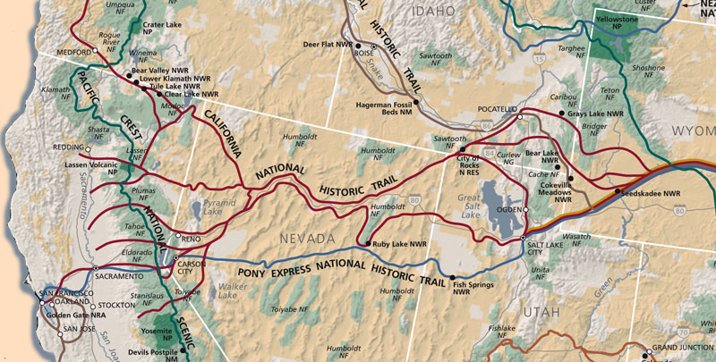
National Scenic and Historic Trails
Monday, July 13, 2015
After a breakfast of a pastrami sandwich with veggies on sourdough with chocolate milk and a fudgesicle at Echo Chalet, I set out with a supplemental load of grapes, cheese, rye bread, chocolate coated chocolate cookies, an apple, avocado, and tomato, I ascended the PCT to Aloha Lake. There I met some PCT thruhikers and their local pals and shared in their beer and salami celebration. I also swam, which was great as it's been too cold for a while. The trail over Mosquito Pass down to the return trail to the Velma Lakes was easy to follow, but north of that the trail was sometimes hard to find or covered in blowdowns. Mosquitos were happy to keep me company while I searched for the next bit of trail. I saw no one after Mosquito Pass, but there were very fresh boot prints.
Miles: 18 447
Camp: North of Camper Flat
Maps: THLakeTahoe/TRT
Route: Roads, PCT/TRT, Aloha Lake, Mosquito Pass, Rubicon River Trail, China Flat, Camper Flat
Tuesday, July 14, 2015
The dirt road I had worried might be obscure or not go through turned out to be the famous and popular Rubicon OHV Trail. Some of the many jeepers out joked that I would finish long before them. Sure enough, I passed many and was passed by only 2. So mostly I stayed out of dust and sliding cars. But the smell of hypoid extreme pressure gear lubricant additives from smashed and leaking equiment was fairly constant. This was an OK route.
Miles: 16 463
Camp: Headwaters North Fork Blackwood Creek
Maps: THLakeTahoe/TRT
Route: Rubicon River Trail (sometimes obscure), Cross country between Rockbound and Buck Island Lakes, Rubicon ATV/4WD Road, road, PCT/TRT
Wednesday, July 15, 2015
I resupplied in Tahoe City, with potato salad, ice cream and olives with lunch, and with plenty of leftover fried chicken for the trail. The next large grocer is in Ashland, Oregon, so I loaded up on staples. I saw a few Mule Deer stotting off into the woods. There was no water between the lake and the Tahoe City Dam (so zero cfm release), which had lots of info for tourists. But further downstream the river flowed well from side creeks and springs. There was a beaver dam in good condition. The bike path was almost entirely separate from highway 89, but there was plenty of traffic noise. You can ride down the gondola into Squaw Valley free, where there is a post office and small, expensive stores, restaurants, etcetera, but it's a big climb or expensive tram ride back up to the PCT. There are several blazed trails from Squaw Valley to the PCT: see the hiking brochure.
Miles: 21 484
Camp: A mile up the Shirley Creek Trail
Maps: THLakeTahoe/TRT, Squaw Valley Hiking Brochure
Route: PCT/TRT, TRT, Tahoe City (resupply), Lower Truckee River (asphalt bike path), Squaw Valley Road (hitch), Shirley Creek Trail

Bird Nest
Thursday, July 16, 2015
A lenticular storm cloud formed over Tinker Knob, Anderson, etcetera this afternoon. A few spots of virga or perhaps rain were well to the east, and thunder cracked only a half dozen times. But a snag ignited between Granite Chief and Tinker Knob after I had passed the fire site. Still, I passed the afternoon wondering whether I should call it in, then watching a helicopter closely examining it, then several times watching a fixed wing turbopropreturn and circle it. As I ascended Lincoln, I could still see a bit of smoke and discussed the fire with some southbound short distance hikers. I found a solar charger on the trail, with a 5000 mAh battery, a 200mA solar charge rate, a 1A usb charge rate, and 2 1A device charge ports. It's about the size of a hand. I'll play with it over the coming days. Had I taken the Granite Chief trail from Squaw, I would have saved a few hours.
Miles: 15 499
Camp: Mt Lincoln, South of Donner Ski Areas
Maps: Squaw Valley Hiking Brochure, NGTI805
Route: Shirley Creek, Western States/Emigrant Trail, Tevis Cup Trail, PCT
Western States Trail
From east to west, the trail links Robie Park, High Camp, Watson's Monument, Lyon Ridge, Red Star Ridge, Robinson Flat, Dusty Corners, Last Chance, Deadwood, Michigan Bluff, Chicken Hawk, Forest Hill, Franciscos, Lower Quarry, and Auburn, near I80. The Western States Trail is today used for the
100 mile Tevis Cup, a horse race, and for the Western States 100 Mile Run. The Western States Trail evolved from an Emigrant Trail in Placer County.
Friday, July 17, 2015
I was talking with another PCTer at Donner Summit when I found a can of refried beans and we enjoyed a bean sandwich and Gatorade breakfast. The powdered Gatorade was from a trail magic stash. I headed to Donner Ski Ranch for lunch, battery charging, and much needed shower and laundry. At the Peter Grubb Hut, two guys who had lived most of their lives on the west side of the Sierras were very interested in my hike: we talked into the night and a couple of hours in the morning.
Miles: 12 511
Camp: Sierra Club Peter Grubb Hut
Maps: NGTI805
Route: PCT, Mt Judah Trail, PCT, 15E32, 80-50, PCT
| Donner Pass History |
|---|
|
Overland Emigrant Trail - Truckee Pass Trail
First Transcontinental Railroad
The First Transcontinental Air Route
The First Transcontinental Highway |
Saturday, July 18, 2015
I saw a fairly tame Mule Deer quite near the trail. A firefighter told me the fire I saw a couple of days ago was designated the Chief Fire and was extinguished by two smoke jumpers from Redding who had jumped in late Thursday, perhaps after I could no longer see that fire. The firefighter was out extinguishing a similar lightning ignited two snag burn on Lacey Peak.
Miles: 21 532
Camp: East of Jackson Meadows Reservoir
Maps: NGTI805
Route: PCT
Historic Gold Mines near Sierra City
Numerous historic lode gold mines line both sides of the North Yuba River Canyon near Sierra City, including the Colombo Mine, the Kentucky Mine, the Keystone Mine, the Monumental Mine, the Sierra Buttes Mine, and the William Tell Mine. A nugget weighing over 1,500 troy ounces was found in the Monumental Mine in 1860, and in 1869, another nugget weighing over 1,800 troy ounces was found there. Placer mining continues in area creeks today.
Sunday, July 19, 2015
I resupplied in Sierra City. Resupply groceries were expensive, but restaurant prices normal. Camping and cold showers were free by the Methodist Church. Socializing with the 25+ hikers staying there was fun.
'Town' 'Hikers'
I had the odd feeling that while perhaps a dozen hikers were taking what I think of as a typical town break of from a few hours up to perhaps a full zero day, the other dozen hikers in town had been there perhaps 4 or 5 days. It wasn't information I would have thought to seek, but some mentioned offhand the several places they had found showers or camped during their stay. It's not odd to me that a hiker or two might be injured or waiting for mail ordered gear. But that half the hikers would just be hanging out or partying that long is new to me. I've noticed a trend over the years that a very small percentage of hikers hikes 35-40 miles per day while on trail, but has to recover for several days in every town. One guy told me that several times he had stayed four nights in a rented cabin off the trail when his family visited, and had rented a large house in Etna which he sublet to random hikers for several days, but I don't think this explains the large numbers. After speaking with a few other diligent observers, I think there is a new trend that some 'hikers' walk very little, or not at all, and simply hitch from town to town following 'the scene' and partying. It must be very time consuming to hitch from a tiny town east or west to a northbound highway, up that, and back into the mountains. It would be cheaper and easier to party in some city someplace. I'm curious to understand the trend, but I'd rather be walking in the wilds than spending enough time in towns to figure it out.
Zero Days on Trail
Two Seventh Day Adventist thru hikers left the PCT every Friday night and camped 2 nights at a lake, campground, or etcetera. Their reasons were only partly religious: they simply liked to take a break and do something else once a week. I started to wonder why I don't take an on trail zero day once in a while. I could do a day hike, bag a peak, read, etcetera.
Miles: 15 547
Camp: Sierra City
Maps: NGTI805
Route: PCT, roads after diversion dam
Monday, July 20, 2015
In the morning I was invited to the trail angel's place next door for coffee, bread, and fruit, which was a great breakfast. Then I ascended Sierra Buttes Road from town to the fire tower. There were many day hikers there. Crazy AZ and I had a long conversation on religion until the end of the day, and we camped together to extend the talking.
Miles: 18 565
Camp: West of Long Lake
Maps: NGTI805
Route: Sierra Buttes and other roads, trail, PCT
Tuesday, July 21, 2015
I saw Quail and logs rolled and torn apart for bug larvae by bears.
Miles: 20 585
Camp: Quincy-LaPorte Road
Maps: NGTI805, ½mile M3-5
Route: PCT

|

|
| Ant Log | |
|---|---|
Wednesday, July 22, 2015
I watched ants hollowing passages in a log. One ant after another carried a grain of sawdust to the sawed end of the log and dropped it into the pile below. Bees were visiting some sticky sawdust elsewhere on the log face. I saw a 2' Garter Snake. After the Middle Fork Feather River bridge an old winch, some cable, some galvanized flue pipes, and other machinery were rusting away. I ran into April Showers, who I knew from a Florida Trail hike a few years ago. Amanda, from the same Chuck Norris group, is about a week ahead on the PCT.
Miles: 22 607
Camp: 3 miles northbound from Bear Creek
Maps: ½mile M5-7
Route: PCT

Winch
Beckwourth Cutoff
James Beckwourth found Beckwourth Pass in the spring of 1850 and by summer of 1851 led a wagon train to Marysville along the trail he had explored in the meantime. The trail left other California Trail routes from the Truckee River near present day Reno, Nevada, roughl north along US395 and west along Highway 70. He established a ranch and trading post near Portola. The trail continued west along Grizzly Creek, American Valley / Quincy, Buck's Lake, Mountain House, Bidwell's Bar / 3 Forks of the Feather River / Lake Oroville, and south to Marysville.
Thursday, July 23, 2015
I walked down to the stores at Bucks Lake. Haskins Store had decent prices and I bought fruit, yoghurt, cheese, and a frozen burrito. I moved on to Bucks Lake Lodge and had a big burger and accepted a complementary beer. I met Crazy AZ, who had arranged a ride to Quincy with the proprietor, so I went along. We visited a dollar store, hardware store, and grocer. I bought a ton of fried chicken, grapes, cherries, potato salad, and chips that I later used to treat 8! people who camped with me. I also have staples for a long stretch of hiking. I need to call home more often as my dad is retaining water.
Black Bear by Camp
A bear came within 10' of our 9 hiker camp after everyone was asleep. He woke me by breaking many large sticks while walking around. From his large lung capacity and baritone breathing, I knew he was pretty big. After trying to wave him off, I yelled "Hey Bear, Get the $%&@ Out of Here!" as loud as I could. The other hikers woke instantly. Someone emptied their lungs through a loud whistle, and another yelled "I've got Bear Spray right here!" The bear ran off but returned later and again foraged right next to another corner of the camp. He seemed to be foraging for his natural foods right next to camp, as he went after no hikers' food, nor did he enter the camp.
Miles: 13 620
Camp: 1 mile northbound from Bucks Creek
Maps: ½mile M7-9
Route: PCT, Big Creek Road, Bucks Lake Road, rides, PCT
Friday, July 24, 2015
I saw prints of bears, deer, Raccoons, and birds. After buying a burger, and trail fruit at the Belden Resort, I began a tough, hot ascent from the North Fork Feather River. There had been thimble berries on the descent, and there were blackberries on the ascent.
Miles: 22 642
Camp: Williams Cabin Site
Maps: ½mile M, N
Route: PCT
Saturday, July 25, 2015
I saw a big Owl soon after leaving camp. By Frog Spring I saw a hawk and some quail. There were some Mule Deer, including one doe with a year-old and a new fawn.
Miles: 18 660
Camp: 1 mile ENE of Humboldt Peak
Maps: ½mile N
Route: PCT
Sunday, July 26, 2015
Where are the retirement age people? Most years they constitute 10-20% of the hikers. This year, I see mostly young thru hikers...
Plans...
I haven't been on the PCT north of the Peter Grubb Hut in 12 years. Though I remember a few parts well, most of the trail might as well be new to me. Plus, I'm enjoying the social interaction with the through hikers. I'm early enough to make it to Canada before winter settles in. Perhaps I'll try to keep a through hiker pace and explore a bit less. So many options...
Miles: 20 680
Camp: 1½ miles south of Highway 36
Maps: ½mile N
Route: PCT, Cub Spring Trail

Terminal Geyser
Monday, July 27, 2015
Today's highlights were Cheetos and root beer for a pre-breakfast snack at a Highway 36 hiker magic cache, a swim in the North Fork Feather (the first since the Middle Fork), and the steam and boiling springs at Terminal Geyser. There were also cold springs there: I should have brought a water bottle. Collins Pine Company Almanor Forest owns much of the land near 36, and has signs and a museum documenting history. Perhaps a website documents the old logging rail grades, now roads or abandoned, and a diversion ditch north of 36.
Miles: 18 680
Camp: Between Terminal Geyser and Boiling Springs Lake
Maps: ½mile N, Earthwalk Lassen Volcanic NP
Route: PCT, Terminal Geyser Trail
Lassen Emigrant Trail
Peter Lassen, in 1848, led a 12-wagon emigrant train from Missouri to California. The route was popular 1848-1853.
Tuesday, July 28, 2015
I enjoyed the mud bubbling sounds at Boiling Lake. The hot springs on the south side of the Hot Creek loop were not flowing. The breakfast, laundry, shower, and hot swim at Drakesbad were excellent. This facility was not open to passing PCT hikers in 2003. Much of the northern part of Lassen NP is burned, with many standing snags. When these begin to fall en mass, all trails in this area will be a mess, and will need many crews to keep blowdowns to a resonable level. The lakes and volcanic features of the park are quite pretty. I think I could easily spend a week or two walking around, especially if I had a book on the geology of the area.
But the trails are separated by main roads, so perhaps this would best be done by car.
Miles: 20 700
Camp: North of Lassen NP Boundary
Maps: ½mile N, Earthwalk Lassen Volcanic NP
Route: PCT, West side of Boiling Springs Lake, PCT, Hot Creek / Dream Lake Loop, PCT, Feather, Silver, and Cluster Lakes, returning to PCT at Badger Flat, Badger Spring, PCT
Nobles Emigrant Trail, California Historic Trail Branch
The Nobles Emigrant Trail, or the Fort Kearney, South Pass and Honey Lake Wagon Road, connects the Applegate Trail to the Willamette Valley in Oregon with the Lassen Trail. It was described by William Nobles in 1851 as an easy cutoff. It crosses the PCT in the north of Lassen National Park.

Boiling Springs Lake
Wednesday, July 29, 2015
Hat Creek Resort has lost its good restaurant of 2003 and its store is now poorly stocked. But I mailed home maps back to the Emigrant Wilderness and the PO PCT register went back to 1999. I hadn't signed it in 2003 but the names of those who had sure brought back memories. JJs was highly recommended and delivered an excellent burger and spinach salad for lunch and cherry pastry for the trail. I wasn't able to buy bread or fruit at the resort or gas station, but Old Man Walking said if I had walked the highway from Hat Creek Resort to JJs, a market there would have supplied my wants. Four of us enjoyed the cool air and adventure of the Subway Cave lava tube. The afternoon was still hot when I began my ascent to Hat Creek Rim. The Sugarloaf Fire burned much of the area in 2009 after ~800 lightning strikes.The Noble and Emigrant Trails passed through northern Lassen NP. The views of Lassen, Shasta, and the valley below were excellent. A cloudless sunset cast shades of purple and orange over the hills and sky. Bats were flying about my camp. Fixie demanded that my book include a chapter on feminine issues and even offered to write it. Just a thorough list of topics would be a good start. ( deva cup, hook method for peeing )
Miles: 20 720
Camp: Trees ½ mile south of Lost Creek
Maps: ½mile N
Route: PCT, Old PCT / Parham? Trail, PCT, road to Hat Creek Resort, Cross Country, PCT, Water Tank, Town Roads to JJs, Gas Station Store, and Subway Cave, PCT
Thursday, July 30, 2015
Yesterday and today were quite hot, adding to the challenge of the Hat Creek Rim Section. But the views of Lassen, Shasta, and the valley were worth it. Several water caches were in place, but whether from a cache or my pack, by afternoon all the water was hot. So what a surprise to find iced sodas and canned foods at Wild Bird Cache at nightfall. A few of us talked into the night.
Miles: 27 747
Camp: Wild Bird Cache north of Highway 299
Maps: ½mile N
Route: PCT

Burney Falls
Friday, July 31, 2015
After a breakfast of chili, crackers, coffee, and cola, I headed for Burney Falls and took the side trail to watch the creek spring from dry to impressive flow, and the falls with so many springs in the walls. A guy on a custom, extra tall bike was riding north through the mountains towards Canada to return later by the coast. He recommended Crazy Guy on a Bike Website as a source of tips for packing touring bikes. After much eating and hiding in the shade at the store and visitor center, I headed out, finding the dam and Rock Creek much as I remembered them. After a brief discussion with a gold panner at Rock Creek, I found swimming in it to be as much of a relief as I did in 2003. I am 1 day ahead of where I was on my 2003 hike.
Daily High Temperatures, °F: 101, 106, 114, 111 (today), 109, 105
Miles: 15 762
Camp: 2 miles north of Rock Creek
Maps: ½mile N, O
Route: PCT, Burney State Park Trails, PCT
Saturday, August 1, 2015
Some white western cumulus clouds were around all day and really were pretty at sunset. Some deer and rabbits were not very afraid. High temperatures, humidity, and water consumption continued.
Miles: 21 783
Camp: before Moosehead Creek
Maps: ½mile O
Route: PCT, Water Side Trails
Sunday, August 2, 2015
The day was cooler, but with high humidity and brief rain showers. Last night, a quick shower got me up to install my tarp. That was no big deal, but I picked up some ants who kept waking me for the rest of the night. There were some ripe Thimbleberries.
Miles: 21 804
Camp: 1½ miles before McCloud River
Maps: ½mile O
Route: PCT, Water Side Trails
Monday, August 3, 2015
The day was hot and humid, but shady, so I walked shirtless. One swim in Squaw Valley Creek was a great relief. McCloud River was McCloudy with glacial flour, but doesn't seem to continue to Shasta under that name. I'll need a better map to look it up. Ash Creek might be a good candidate considering Ash Camp... I cold cooked 3 different meals of Quinoa grits, Oatmeal, and Hummous. All worked ok, and all were made in zip sandwich bags. The grits were soft in a couple of hours. There were occasional great views of Shasta.
Miles: 29 833
Camp: After dirt road north of North Fork Fall Creek
Maps: ½mile O
Route: PCT
Tuesday, August 4, 2015
There were two swims and no shirt on another hot, uphill day. At Castella, I had a roast beef and Swiss sandwich, ice cream, and loads of soda. I carried out a burrito, chips, bread, and fruit. Just after the market I saw several Mule Deer bucks with good racks in velvet. The Flume Trail had ditches and boards, sometimes intact, and ruins of old trucks and equipment. The flume sometimes had a 1' square section and sometimes a larger trapezoid section. There were two survey markers 7-8' apart - Oops. I saw a striped Garter Snakes, and later Pitcher Plants at Gully Spring. There were many great views of the Castle Craggs as today's hike wrapped around the mountain.
Miles: 21 854
Camp: Saddle after Gully Spring, View of Mount Shasta
Maps: ½mile O, P
Route: PCT, Roads, Sacramento River Trail, Amarati Market, Flume Trail, PCT

Flume
Wednesday, August 5, 2015
Another PCTers dog has been going behind me and barking and snapping at me since yesterday. I've run into them often at water sources. The guy apologized to me and says that the dog doesn't do this to other hikers. He's agreed to try to control the dog when I'm around. But if I owned a dog who was threatening other hikers, no one would need to talk to me before I restrained the dog. And I would train the dog or send it home...

Pitcher Plant
The Callahan-Sisson Trail crosses the PCT several times. There are other trails that appear to go some distance. They are in good shape near the PCT. The Castle Craggs State Park free map (PDF?) is a good topo map for the Craggs. There is a USFS Shasta Trinity NF topo map for the Castle Craggs wilderness that covers a larger area. The regular STNF map covers from the Craggs half way to Seiad Valley. I saw two logging operations this morning. A group of half a dozen young Mule Deer, one a buck with a small velvet rack, were not very afraid of me as I walked the trail. Smoke from distant fires reduced visibility to a mile by the end of the day.
Miles: 28 882
Camp: Cement Bluff, View
Maps: ½mile P
Route: PCT
Plaque at Road 3 and PCT, Lat 41° 16' 32" Lon 122° 41' 52"
California-Oregon Stage Road
1860-1887
A pack trail by 1851, Greathouse & Co. muled passengers by 1854. James F. Carr, contracted by the California Stage Co., finished the last six miles of road from Trinity River to here, Sept. 14, 1860. The first daily mail and passenger stage, driven by Williamson Lyncoya Smith, crossed over two days later. A stage stop and 100 mule barn, for lodging, meals and relief teams was located here. The winter road was kept open by oxen to break trails and sleighs to carry passengers and express. Known as the Western Branch of the California-Oregon Trail, safer from Indian raids than trails to the east. This old toll road fell to disuse by completion of the railroad in the Sacramento River Canyon, in 1887.
Dedicated by Humbug Chapter 73
and Trinitarianus Chapter 62
E Clampus Vitus, Sept. 13, 1986
Thursday, August 6, 2015
An 18" Garter Snake examined all around 3 hikers throughout a long lunch break, and even climbed atop my pack and within 6" of my head. He was much shier when the camera was out. His stripes were yellow and he had red spots along his sides.
Miles: 24 906
Camp: Southeast of East Boulder Lake, voices and cowbells from the valley below
Maps: ½mile P
Route: PCT
Friday, August 7, 2015
It was much smokier today, with sharp wood smoke smells and visibilities of less than a half mile. The trail was endlessly tough, with much upping and downing, and much loose rock. There was a recent burn in the last few miles of the day. A southbounder counted 30 nobo thruhikers today.
Miles: 22 928
Camp: North of Statue Lake
Maps: ½mile P
Route: PCT
Saturday, August 8, 2015
A breeze developed and cleared much of the smoke by the day's end. It brought some lenticular and high, icy clouds, but clear weather with high temperatures of 88-95°F are predicted for the coming ten days. It seems a bit cooler. Etna was a good stop, with a well stocked small grocer, a library with wifi, and various places to stay. I stopped at the museum and enjoyed the crank era telephones and Indian baskets. I rode down with an ex professional racing sailor and skier who now lives in the woods. The local fire chief gave me a ride out of town even though he hadn't planned to go to Etna Summit. We picked up two more hikers before leaving town. Perhaps ¾ of the way up, he got a call for a porch fire and an 81 year old guy with chest pain. I told him if he needed to respond, just to let us out. But he was sure someone else would answer the call. After a minute or two of radio silence, we found ourselves on the side of the road. The sailor, now returning home, stopped and got me to the summit. Thanks to all, and good luck to the 81 year old guy.
Miles: 18 946
Camp: ½ Mile Southeast of Shelly Lake
Maps: ½mile P, Q
Route: PCT
Sunday, August 9, 2015
After meeting a few people before mid morning, I saw no one until I camped. That's probably as long as I've been alone in 2015. In 2003 there were 24 days I saw no one. In speaking with 2015 hikers, almost nobody has had a whole day of solitude. That's too bad, as I truly value my days alone. On the other hand, Crazy AZ had 5 consecutive days alone in southern California in spite of starting in early May, with many others starting about the same time. There were salamanders swimming in the ponds near Marten Lake, but not nearly as many as in 2003.
Miles: 24 970
Camp: 1 Mile North of the Tyler Meadows Trail Junction
Maps: ½mile Q
Route: PCT
Monday, August 10, 2015
The 2014 Happy Camp Complex Fire (Ignited by lightning August 12, 2014, 134,056 Acres) cleaned out the long brush tunnel along Grider Creek on descent into Seiad Valley. But the area is still lush with Poison Oak. I resupplied and ate out of the store as the restaurant closes mid afternoon.
Miles: 25 995
Camp: 1 Mile North of Highway 96, Near Fern Spring
Maps: ½mile Q, R/A
Route: PCT
Tuesday, August 11, 2015
I saw a 10" Garter Snake. Shasta was clearly visible late in the afternoon. Due to smoke, I haven't seen it since before Castella. The Boundary Trail, part of the Bigfoot Trail, looked to be in OK shape, and was a long PCT like level traverse under a ridgeline running west from the PCT. Steady from 2003 was southbound and said she had seen 30 northbounders by mid afternoon.
Miles: 23 1018
Camp: 4 Miles North of Bear Dog Spring
Maps: ½mile R/A
Route: PCT
Boundary National Recreation Trail
Rogue and Siskiyou National Forests, Length 15.60 Miles

Donomore Cabin
| Some Locations | |||
|---|---|---|---|
| Name | Comment | Latitude °North |
Longitude °East |
| +4Q Rockbound Aloha | 38.943444 | -120.187240 | |
| +Road Trail | 38.995230 | -120.247719 | |
| Photo DSC00551 | JoinedATVroadRubiconTrMile5.75BigSluice | 39.004853 | -120.246348 |
| +PCT GraniteChiefTrail | 39.210696 | -120.276371 | |
| +PCT AndersonPkTr TrToTruckee | 39.262966 | -120.296837 | |
| +SierraButtesRd DumpRoad | 39.566994 | -120.652488 | |
| +SierraButtesRd Road TurnSWBck | 39.576266 | -120.661476 | |
| +4Rds SierraCity5m ButtesTower | ButcherRanch/MonarchRd 9-32 12e07 92-2-3 | 39.587854 | -120.668064 |
| +PCT RightHandBranchMillCreekT | 39.932187 | -121.136987 | |
| +PCT MillCreekTrail | BothMillCrTrlsOKatPCT UseToWalkFromBucksLakeStores | 39.972775 | -121.203009 |
| +PCT 3LakesTr GoodCondition | 39.975081 | -121.218298 | |
| +PCT LostCreekTrail Campsite | 40.758313 | -121.396772 | |
| RedMountainPond | 41.098629 | -121.795195 | |
| DSC00593 | Flume12"squareSection orDitchElsewhere NofCstleCrR | 41.149863 | -122.332703 |
| DSC00594 | 7-8'Apart | 41.160858 | -122.351618 |
| GullySpringPitcherPlants | 41.213855 | -122.392859 | |
| +PCT BoundaryTrail BigfootTrl | 41.911910 | -123.200838 | |
| AlexHoleSpring | 41.932732 | -122.968942 | |
| Name | Comment | Latitude °North |
Longitude °East |