
Air Compressor
Grandview or Last Chance Mine
August 3 - 5, 2019
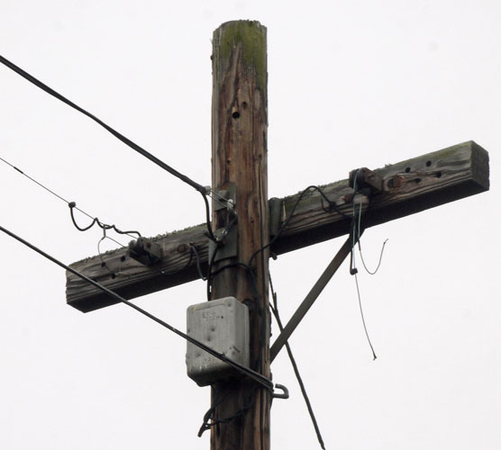
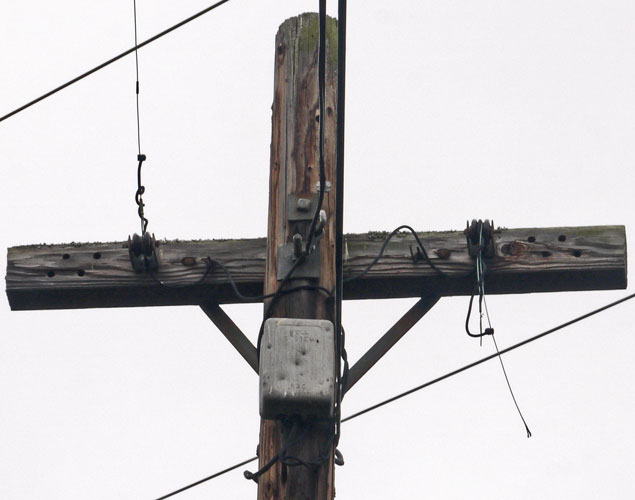
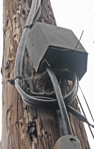
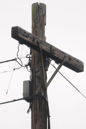
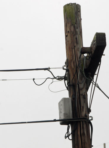
I visited Grand Canyon's south rim, hiking the Rim, South Kaibab-Tonto-Bright Angel Trails, and the Grandview Trail to Page Spring. The following photos are of the Grandview or Last Chance copper mine, which was opened by Pete Berry in 1892 and operated intermittently until 1907. The ore was excellent - 70% copper, but transporting it to a mill made it a money loser. Remains include stone building ruins, mine tunnels and tailings, iron mining equipment, and an interesting can dump. In some cases, the solder has disappeared, allowing examination of each tin can component. Someone suggested mercury or other chemicals used to purify ores may have dissolved or corroded the solder.
|
Air Compressor Grandview or Last Chance Mine |

Jack The rod squeezes between the mine wall and supports a jackhammer, drill, etcetera. |

Mine Tunnel |

Wheelbarrow |

Winch |
| Maybe a rodent nest in an engine compartment would not be suprising if the car was left for a long time, but I check the fluids under the hood every few days, and this happened when I was sleeping in different spots in the Kaibab NF each night, and parking at different Grand Canyon NP trailheads every day. |

Rodent Nest by Car Battery |
August 8, 2019
Cedar Breaks National Monument
I walked the Ramparts, Sunset, and Alpine Ponds Trails. These few miles of trail are along a cliffline. To the east is the surprisingly (for Utah) lush Markagunt Plateau and ecosystem, while the trails overlook an eroded sandstone basin with hoodoos to the west. Two creeks (Shooting Star and Alpine Pond) were flowing a foot wide and an inch or two deep. I started at dawn and had hiked the trails and gone to the vistor center by lunchtime. For a longer visit, one could approach the badlands from the west in Dixie NF's 6,750 acre Ashdown Gorge Wilderness. At 8,000 to 10,400 feet, the wilderness supports Bristlecone Pines growing in the colorful eroding Claron Limestone. There are Rattlesnake Creek, Potato Hollow, and Long Hollow Trails. 11,307' Brianhead Peak is just north of the park.
August 8, 2019
Petroglyph
I then visited Parowan Gap (BLM) dinosaur footprints and petroglyphs. The footprints were not nearly as clear as other sites, but the petroglyphs were outstanding, representing different eras and tribes.

Petroglyphs |

Petroglyphs |
| There is little agreement between these two interpretations of this panel. I prefer to not worry too much over the exact meaning and instead wonder over the beauty and antiquity of the art. |

Archaeology - Astronomy Interpretation of Petroglyph Panel by Nowell Morris |

Paiute Indian Interpretation of Petroglyph Panel |
August 9-11
There were excellent limestone formations in the caves, and a good tour was cheap relative to other caverns. There were good interpretive displays on the Bristlecone Pines in the Bristlecove grove on the flank of Wheeler Peak 13,063', and in the two visitor centers. The Osceola Ditch Trail was mostly a sidehill ditch, sometimes in good repair, and intermittently a flume in areas of unstable soil. The trail is out of repair in and north of a recent burn in the north of the park, but the ditch could be hiked to the historic mining town of Osceola, still populated. Most of the below photos are from the Johnson Lake Tungsten Mine on Snake Creek. The mine was claimed in 1908 by Alfred "Timberline" Johnson and Thomas Dearden. It was profitable through WWI.

Beaver Engine |

Beaver Engine |

Chevy Transmission 590391 4 1 20 9 |

Compressor |

Compressor |

Arial Tram From Mine To Near Johnson Lake Brackets Marked No 1236 |

Pulley / Sheave in Johnson Lake An avalanche chute moves gear and debris from near the mine and the path downhill into Johnson Lake. The 'town' is a few minutes away, safe from the avalanches. |

Aspen Sap Flow From Insect Holes |

Topo Maps of Great Basin NP |
|
There is a Humboldt-Toiyabe National Forest and BLM Highland Ridge Wilderness to the south, not fully covered by these 7½' topo maps. There is an out of print Earthwalk Press map of roughly the same area shown above. A volunteer said walking cross country in the park and wilderness is easy. There are many more ridge areas along the Snake Range and the other parallel ridge ranges in the area; many have Bristlecone Pine groves. Hiking these might be interesting; a Humboldt-Toiyabe National Forest map or topo map book might be adequate. |
BLM's 704,000-acre Basin and Range National Monument
A not very detailed map is available on line at the monument's website for this 2015 designated monument. I'll have to visit someday.
August 12 - 15, 2019
On the 12th I visited all public access points on Mono Lake. More interesting hikes from dirt roads are available.
On the 13th I saw the petroglyphs along the Fish Slough Road north of Bishop, and then visited the Laws Museum. In the evening, I drove up into the White Mountaines and walked a half dozen miles in Schulman Grove and Mexican Mine area.
I summited White Mountain 14,246' on the 14th. There was plenty of time left in the afternoon, but no energy. I read and catnapped the rest of the day.
On the 15th, I visited the Patriarch Grove and Manzanar National Historic Site.

Fish Slough Petroglyphs |

Fish Slough Petroglyphs |

Fish Slough Petroglyphs |

Fish Slough Petroglyphs |

View East From White Mountains Deep Springs Lake See: 7½' topo map Deep Springs Lake |
Publications on the White Mountains
In case I want to explore the Whites more thoroughly, the following three publications might help. The out of print natural history book appears thick, but only the first hundred pages uniquely discuss the White Range. After that comes hundreds of pages of animal and plant description. A geological chart is included in a pocket in the back. The commercial plastic topo map seems good. Most interesting parts of the range are accessible by 4WD are heavily visited. To the south of the highway the range east of the Sierras is known as the Inyos; it is much lower and it would be covered in different publications.
Natural History of the White-Inyo Range
Eastern California
Edited By Clarence A. Hall, Jr.
A Garden of Bristlecones
Tales of Change in the Great Basin
Michael P. Cohen
White Mountains ($11)
Recreation Topo Map
Includes Ancient Bristlecones
Big Pine to Montgomery Pass
Sierra Maps
Just after this trip I read 'A Garden of Bristlecones', listed above. It does a good job of discussing many good and bad issues surrounding the Bristlecone Pines. I also read 'The bristlecone book : a natural history of the world's oldest trees' by Ronald M. Lanner, 2007, which covers the trees themselves more thoroughly.
What's fascinating about Great Basin Bristlecone Pines Pinus longaeva, is that there are living trees about 5,000 years old, and dead wood from trees growing well over 10,000 years ago. By not only counting rings, but matching up patterns of thick and thin rings, there is a complete history of good growing years and bad years with thin rings for the last 11,500 years. The trees at the upper elevations are mostly limited by temperature, where those at the lower end are limited by each year's precipitation. By carefully correlating long thick - thin sequences from many trees, and carbon dating a continuous series of samples of just a few year's wood, C14 radiocarbon dating has been calibrated very accurately. So archaeologists can not only accurately date all sorts of ancient things all over the world, but correlate them to periods of pleasant climate or colder, drier eras. The era covered includes all of the development of man from hunter-gatherers and cave men through modern time. Many old theories about the sequence of prehistory were overturned with the much more precise dating yielded by the tree rings. There are plants that are probably older, but their older parts rot away, so the bristlecones are unique in giving us these records.
August 16 - 18, 2019
During many past visits to the Pacific Crest Trail at Kennedy Meadows South, I had wondered abouth the areas west of Kennedy Meadows, or south of the Golden Trout Wilderness. When I had asked about the road from Kennedy Meadows to Kernville, people had always tilted their heads back and rolled their eyes, leading me to believe it was some horrible dirt road. Actually, it is a good asphalt road, with paved spurs north to the Golden Trout Wilderness near Blackrock. But most of it is curvy, best travelled at 25 or 30 miles per hour.
At the Blackrock Visitor Information Station (Elevation 8,150'), I met Ann, who was both very informative, and knew how to ask great questions. She recommended entertaining hikes, and I returned the favor by reporting back all sorts of stuff. She told me a little bit about the phone system near Blackrock and the artifacts in their display case, and sent me down to the Kerville Museum, which was a bonanza of USFS phone system artifacts. There is also a research annex, which was not open the day I was there, where there might be more artifacts and especially documents.
I walked to Manzanita Knob the first day, meeting two rattlesnakes. Their camoflage was excellent; I didn't find one in plain sight for several minutes, and couldn't find the other one amongst bushes at all. The view from the knob to the west was excellent.
On the 17th, I walked to Casa Vieja Meadow, Little Dry Meadow, Big Dry Meadow, and back through Casa Vieja Meadow. Between Little Dry Meadow and Big Dry Meadow the trail was disappearing in overgrowth. A tin can dump behind the west Casa Vieja Meadow cabin had cans from near the 1960's and a wood stove. For reasons unknown, there are two cabins plus outbuildings in Casa Vieja Meadow.
On the 18th, I walked to Casa Vieja on the trail from Osa Meadows. It had one modern PCT metal blaze. I wondered if this was one of the historic PCT routes, before the north of Kennedy Meadows - south of Walker Pass section was built.
I purchased the Dome Lands Wilderness USFS map. Many or most of the trails in this area are little used and damaged by wildfire, but I have long been interested and hope to return when the weather is cooler. There are many trails between the Domeland and Golden Trout Wildernesses, but they are largely open to and heavily used by motorcycles, so are probably not good destination hikes.

Rattlesnake |

Manzanita Knob Panorama |

Plow Behind East Casa Vieja Cabin |

Sprayer Behind East Casa Vieja Cabin Dobbins Manufacturing Elkhart, Indiana Power Sprayer Model No |

Casa Vieja West Cabin |

Log Outhouse The sturdy and high quality construction make me wonder if this was once a bear proof food storage building with a root cellar. There is an oval hole and hardware in the rotting floor now, indicating its last use was as a toilet for the west Casa Vieja Meadow cabin. |

Peggy Washington Woodstove Door |

Cans Circa 1960s, Wood Stove |

South Sierra Topo Maps |

Generator from Jordan Hot Springs, Blackrock Visitor Center |
|
Master Vibrator Co. Dayton, Ohio Alternating Current Generator Model No MG3 MachNo 18187 Type AG Frame 225 KVA 2 Volts 120 Cycles 60 Amperes 15.7 Phase 1 RPM 1800 KW 1.6 Cont. 500 Manufactured by The Master Electric Co. Dayton, Ohio, USA |

Blackrock 2 Insulators 2 Types of Insulators, Sloppy Workmanship, Girdles Tree |
August 16 - 18, 2019
I photographed the old wire in trees near the Blackrock Station. Across the road from the Visitor Center and a few hundred yards south / downhill, there is typical #9 wire, but then near the station there is probably copper coated iron wire about 5⁄64" diameter. In this smaller wire there are many breaks, so few if any spans still horizontal between trees, and many crimp sleeve splices on extant wire. The workmanship on these lines near the station is poorer than that out in the woods, so I suspect it was retrofit after the age when people really understood these systems, and how to work on them.

Blackrock 3 Insulators East of road. Egg type insulator (upper right) held wire in tension over the road. The split insulators (center and lower left) held the wire only an inch or two from the tree. |

Blackrock Brown and White Insulator Halves, 9BWG Iron Wire |

Blackrock Insulator, Iron-Copper Wire |

Blackrock Splice |

Blackrock Splice |
|
West Casa Vieja Cabin Ground
Note Fabric and rubber insulated wire. Text PATD probably means patented. Probably part of a phone in the cabin, but possibly installed for a radio or generator supplied power. There is also a plastic tube entering the cabin, suggesting there was once running water. |

|

Casa Vieja Hook There were several of these installed at intervals of several feet along a downed log, suggesting that though these hooks are of a telephone type, they were probably installed for some other reason. |

Fuse Relay |
|
Fuse Relay for U. S. Forest Service Fire Phone Line
Blackrock-Bald Mountain-Beach-Kernville There are marking on the glass tube, but I was not able to read them. The block is marked 'ground' at left, 'VAC-1.1 N. E. S. Co' in the center, and 'line' for each connection at the right. On display at the Sequoia NF Blackrock Visitor Center |

Fuse Relay |

|

|

|
|
Lightning Arrester U. S. F. S. Lightning Arrester Type C-G 1933 On display at the Sequoia NF Blackrock Visitor Center | ||
August 18, 2019
I visited the Kern Valley Museum, Kern River Historical Society. They had an excellent display of old USFS phones and insulators assembled on a wall, as well as other old phones and insulators. A 1916 version of the Sequoia NF map showed the route of the lines, as well as other phone facilities. I have seen similar information on other old USFS maps. A research annex across the street may have more phone system artifacts and documents.

|

|
|
1891 Western Electric Long Wall Type Phone Used in first Single Line Isabella system started by John Danner. #254 | |
|
Army Surplus EE8 Phone
EE8 Notes |

Army Surplus EE8 Phone |

Short Wall Type Phone Over Blackrock Station Phone Black Metal Case |

Kellogg Desk Cradle With Hand Set |

Cannell Cabin Phone Kellog Desk Cradle with Handset Over Generator and Bell Box |

Cannell Cabin Phone Detail Long and Short Ring Sequence to Call Specific Phones Note Helicopters were in use when this list was made. |

Western Electric Candlestick Desk Stand Phone |

Phone From Edison Borel Forebay |

Phone From Edison |
| The museum had three of these hooked together at various places so visitors could call on them. These phones were used by Southern California Edison at their Hydroelectric Dams, but were probably interoperable with the phones in the Forest Service system. | |

Rotary Dial Phone Note the newfangled dial. This phone is of later technology than the phone systems featured here. |

Switchboard with a Dial Too An intermediate technology, this switchboard allows the operator switched systems I discuss above to be connected to an automated rotary dial switched system, such as the Bell network. |

Cleat / Insulator |

Cleat / Insulator |
| Cleats and insulators for pole mounted lines. The US Forest Service avoided poles and used tree mounted lines wherever possible. Many pole lines have rotted away, but I've found just a few. | |

Insulators and Crossarms Very typical in railroad signalling, telephone company, and power lines, not common for USFS. |

Many Types of Insulators |

Ceramic Insulator in Oak Tree |

Ceramic Insulator in Oak Tree (Marked T) |

Ceramic Insulators in Oak Tree | |
|
These are not typical of forest service systems. Perhaps they were part of someone's private line. Museum Label: Phone Insulators on Black Oak, Davis Station Area, Greenhorn Mountains | |
For the next week +, I took my mom to a cornea surgery, and two followup appointments. This left plenty of time to visit Marie, Roy, Kate, and Puffy, and friends Jim, Don, and Gene. I also hiked in many coastal wetlands: Batiquitos, San Elijo, and San Dieguito Lagoons, Mission Beach, and the Tijuana River Estuary west of the US Navy airfield, and swam at various beaches.

San Elijo Lagoon Trails |

San Elijo Lagoon Trail Closures |

San Diego County Watersheds |
| To the south, the upper left of this map, the Pacific Crest Trail runs north from the Mexican Border just above / east of the tips of the headwaters of the creeks that run to the Pacific Ocean, including the San Diego River. Starting with the San Dieguito River headwaters, the PCT is further east, amongst creeks flowing to the Salton Sea. The PCT more or less follows the divide until it drops into the Anza Borrego Desert east of Lake Cuyamaca. There are several trail systems being developed in San Diego County to follow these drainages from the coast to the crest. The most complete is the San Dieguito River, but they are all dashed lines - a nice trail for a few miles followed by a gap, repeating. They are all in somewhat populated areas and somewhat not open to camping - more suited to day hikes than multi-day trips. |
| Long Trails of San Diego County | |
|---|---|
| Only a few are complete and continuous. Maybe someday... | |
| California Coastal Trail, San Diego County | 76 miles along Pacific Coast |
| California Riding and Hiking Trail | Otay Lakes Reservoir to Warner Hot Springs |
| Otay Valley Regional Park Trail | San Diego Bay to Otay Lakes Reservoir |
| Coast to Crest Trail (San Dieguito River Park Trail) | 55 river miles to crest at Volcan Mountain |
| Juan Bautista De Anza National Historic Trail | Desert to Warner Hot Springs |
| Pacific Crest Trail | Campo to Warner Hot Springs |
| San Diego River Park Regional Trail | 52 river miles, Ocean Beach to Inaja Memorial |
| Sweetwater River and Loop Trail | 11 mile Sweetwater Reservoir loop |
| Trans-County Trail / Sea to Sea Trail | 110+ miles, 70% complete, Pacific Ocean, Los Peñasquitos Creek, San Diego River, Salton Sea |

No Trail |

No Trail |

Trapdoor Spider Lair |

Trapdoor Spider Lair |
| To the left is a trapdoor spider silk lined tunnel. Two trapdoors silk or bottom side up are below, as is a section of muddy, dug up tunnel. On the right the trap doors and loose tunnel section are flipped over, with the mud coated side of the doors showing. There were various trap doors, open tunnels, and parts laying about. The ranger suggested a skunk as a known predator of trapdoor spiders. I usually see the tunnels intact, with doors in place and hinged. | |
Because I am interested in US Forest Service phone lines from the early 1900s through the post WWII era, I explored this Bell System line of 8 poles, one dating to 1930 and another to 1956. The construction details are quite different, and provide an interesting case for comparison. An old lady walking her dog said she was a long time local, and the line had been there for decades.
|
|
|
Above and below are 5 pictures of the most southwest pole, which I'll number 1. I did not find a date nail on #1. I am most interested in the two copper coated iron wires that run on glass or ceramic insulators, the highest on the various poles. They start here anchored on spool type brown glazed ceramic insulators. The tension is taken on zig zag shaped crimp sleeves, which seems like poor practice. Perhaps the line once went further and was shortened here after skills and parts for this type of phone line were more rare, and perhaps when the housing developments to the south were built. Wire ends seem squashed into spade type connections, but no longer used. Polymer insulated wires are attached with screw splices. A drawn sheet metal box is marked Bell System 83C, and is pocked with bullet or bb dings. Note the copper coated iron wire is spliced with sleeves many places. The Galvanic series says that copper in contact with iron will cause the iron to corrode first. There are also two rubber coated cables carrying perhaps a dozen twisted pairs of small diameter copper wire. In the air, a tension carrying wire is molded with the outer cable casing, but not underground. The splice box is shown below and left. Ends of yellow insulated wires protrude, I estimate 22AWG solid copper. A similar splice box is on pole 5; perhaps there are more. Older, perhaps abandoned wires or cables are present along the pole above this box. |
||
|
|
|
|
Corrosion and the Galvanic Series See too that copper has a lower potential than iron. For the purposes of this page, that means that if you have a copper coated iron wire, and you scratch through the copper coating, the copper will cause the iron to corrode away in a pit under the scratch. Such a pit may rapidly grow all the way through the iron core. Since the iron provides the strength of the wire, the pit causes the wire to break. Even so, the phone companies liked to use copper coated iron wire because alternating currents travel mostly on the outside skin of wires. A cheap and strong iron core surrounded by a much more conductive copper skin works well with proper treatment. But sloppy workmanship, such as pinching through the copper coating with pliers, will cause early failures of this type of wire. |
| ||||||||||||||||||||||||||

|
Two views of poles 2, 3, and 4, left to right. I did not beat through the brush to examine these poles close up, but they seem similat to 5 and 6, which were much closer to the trail. Note the excessive sag of one wire due to the missing insulator. |

|

|
|

| ||
|
Pole 5 Note two types of insulators, and different wrapping styles. Note insulator cleat pulling away from pole. The pole date nail indicates 1954. The wire is bent. Perhaps it was on the ground and someone bent it repeatedly to break it and get it out of the way. Note the iron and copper wire oxidation colors. |
||||
|

| ||||

Poles 7, 8, Left to Right |
Santa Rosa and San Jacinto Mountains National Monument
I stopped at the visitor center on Pines to Palms Highway 74 and bought an excellent topo map, covering the area north of the Anza Borrego Desert and East of the San Jacintos. This will be good winter hiking. There is a local map store, Desert Map and Aerial Photo, 73-612 Highway 111, Palm Desert, CA 92260, sales@desertmapandaerial.com, (760) 346-1101.
Kendrick Mountain Wilderness Trail System Work Status
August and September, 2019
In early August, the Pumpkin, Bull Basin, and Connector Trails had been fully marked with orange wire flags. The soil is rocky, and many flags fell over into the weeds almost immediately. I wonder if there isn't some small version of a fence post driver to install wire flags better. I was impressed that the crew found the center part of the Connector Trail that I hadn't found and I had assumed had been wiped out by cattle and erosion. Only a bit of trimming incidental to finding the trail had been done.
In early September, most of the Bull Basin Trail treadway had been nicely grubbed through the first Aspen patch, to the ridge. It was much easier to find and walk in the treadway. A saw crew had cut many blowdowns above the grubbed area, along the rising traverse to the plateau / spring area. Many more blowdowns remain, but I'm very impressed with the work done so far.
Kendrick Mountain Wilderness Pumpkin Trail Telephone System
September 1, 2019
A volunteer working in the Kendrick Mountain Fire Tower said the tower had been built in 1964, and though he had been visiting it for decades, he had never seen or heard of any remnant of the old Forest Service Phone System in the tower. I walked down the ridge line, intermittently north of the Pumpkin Trail. ¼ mile east and west of the old cabin ruins (burnt in the Pumpkin Fire), old #9 iron wire is on the ground, with a couple of Western Union Type Splices, but I saw no crimp sleeves or tree insulator hardware. Smaller diameter iron wire with Western Union splicing is present near the cabin ruins.
I also saw no sign of the old phone system at the Apache Maid Tower yesterday.

Coors Aluminum Can Opened by Churchkey - Before Pull Tabs |

Opened by a Curved Church Key - Rare |

Upper Fill Lid Embossed |

Lower Fill Lid Steam Holes |

Self Opening Cans With Key Peeled Strip |

Can Openers? Laws Museum, Bishop |

At the Grandview Mine, Solder is Dissolved Away on Some Cans, Allowing Examination of Each Piece Part. |

Pull Tab - Spitz |

Valve Spout Detail |


