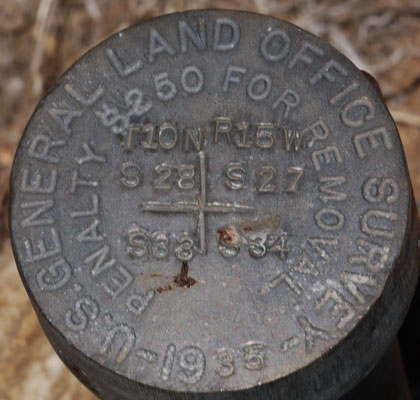
This marker shows a location of the corner of sections 27, 28, 33, and 34 in T10N R15W.
Corresponding markings on maps allow hikers to find their locations.
Hikers and the Public Land Survey System
Most of the land in the western United States is surveyed into 1 square mile sections. Corners of these sections are often marked on yellow tags on trees and on bronze markers on the ground. Hikers who understand the meaning of these markers can use them to navigate. Hikers can also understand certain aspects of forestry, mining, and ranching by reading these markers and understanding some of this system.

|
This marker shows a location of the corner of sections 27, 28, 33, and 34 in T10N R15W. Corresponding markings on maps allow hikers to find their locations. |
History of the Public Land Survey System
After the revolutionary war, the federal government was cash poor but had many debts. Its taxing powers were very limited. At the same time, the original 13 colonies, now states, had ceded to the federal government lands to the west which they had claimed. The government wanted to sell land to pay debts, and to give land to veterans of the revolutionary war. They needed a systematic and quick way of dividing the land into parcels. The system they developed was eventually applied to other lands acquired by the federal government by treaty, such as Florida, the Louisiana Purchase, the formerly Mexican lands, and Alaska.
Georgia, Connecticut, Delaware, Kentucky, Maine, Maryland, Massachusetts, New Hampshire, New Jersey, New York, North Carolina, Pennsylvania, Rhode Island, South Carolina, Tennessee, Vermont, Virginia, and West Virginia, already being settled at the time, were exempt from the new system. Also exempt were acquired lands already parceled out, such as the Mexican and Spanish Land Grants. After all, if the federal government couldn't sell the lands, it didn't need to survey it. Furthermore, military reservations and lands under navigable waters, for example, were not to be sold, so parceling was not required. For hikers, the point here is that the system I'll discuss doesn't exist everywhere we hike. Still, it was used in most of the west.
The Land Ordinance of 1785 and the Northwest Ordinance of 1787 were the first official descriptions of the system. Other acts and regulations came along periodically to fix various flaws, but the system changed little enough that so far as hikers are concerned, knowledge of the various changes is not necessary.
The General Land Office originally administered the surveys, but it was eventually folded into the Bureau of Land Management, which administers the surveys today.
The Public Land Survey System
Meridians
Because it would be difficult with the crude (relative to today) equipment available in those days to measure entirely across the United States, 37 points were selected. These points were called Meridians or Initial Points. They consisted of a Meridian (a North-South line) and a Base Line or Baseline (an East-West line). Surveys were conducted starting at these points and parceling out land. Each Meridian was used to survey an area about the size of a state.
Cadastral Surveys
Surveys to determine boundaries of land parcels are called Cadastral Surveys. Markers labeled 'Cadastral Survey' were placed in an effort to parcel out land.
Geodetic Surveys
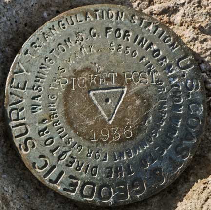
Markers labeled 'Geodetic Survey' or 'Triangulation Station' were placed in an effort to understand the topography of the land by triangulation, not to establish parcel boundaries. They usually don't have a PLSS coded location stamped into them. Markers atop peaks are typically geodetic markers. Often several markers are in the vicinity of the Triangulation Station. Only one marks the key location. The others have arrows to help the surveyor find the marker, or if the marker has been destroyed, to help reestablish it.
Still other survey markers may not have a PLSS location code because they are not located at the ¼ mile increments which are the smallest resolution that can be described by the PLSS.
| Meridians or Initial Points | ||||
|---|---|---|---|---|
| Meridian Initial Point |
Year Established | Baseline Latitude °N |
Meridian Longitude °W |
Area Surveyed |
| Washington Meridian | 1803 | 30.99889 | 91.16000 | Mississippi |
| Saint Stephens Meridian | 1805 | 30.99750 | 88.02222 | Alabama Mississippi |
| Second Principal Meridian | 1805 | 38.47056 | 86.45583 | Illinois Indiana |
| Third Principal Meridian | 1805 | 38.47417 | 89.14833 | Illinois |
| Huntsville Meridian | 1807 | 34.99083 | 86.57111 | Alabama Mississippi |
| Louisiana Meridian | 1807 | 31.00861 | 92.41528 | Louisiana |
| Michigan Meridian | 1815 | 42.42444 | 84.36472 | Michigan Ohio |
| Fifth Principal Meridian | 1815 | 34.64583 | 91.05194 | Arkansas Iowa Minnesota Missouri North Dakota South Dakota |
| Fourth Principal Meridian | 1815 | 40.01389 | 90.45306 | Illinois |
| Saint Helena Meridian | 1819 | 30.99889 | 91.16000 | Louisiana |
| First Principal Meridian | 1819 | 40.98944 | 84.80306 | Ohio Indiana |
| Choctaw Meridian | 1821 | 31.87556 | 90.24472 | Mississippi |
| Tallahassee Meridian | 1824 | 30.43417 | 84.27722 | Florida Alabama |
| Fourth Principal Extended Meridian | 1831 | 42.50750 | 90.42694 | Minnesota Wisconsin |
| Chickasaw Meridian | 1833 | 35.03278 | 89.24639 | Mississippi |
| Willamette Meridian | 1851 | 45.51972 | 122.74278 | Oregon Washington |
| Mount Diablo Meridian | 1851 | 37.88167 | 121.91306 | California Nevada |
| San Bernardino Meridian | 1852 | 34.12028 | 116.93000 | California |
| Humboldt Meridian | 1853 | 40.41722 | 124.11944 | California |
| Sixth Principal Meridian | 1855 | 40.00194 | 97.36889 | Colorado Kansas Nebraska South Dakota Wyoming |
| New Mexico Principal Meridian | 1855 | 34.25972 | 106.88667 | Colorado New Mexico |
| Salt Lake Meridian | 1855 | 40.76972 | 111.89083 | Utah |
| Gila and Salt River Meridian | 1865 | 33.37722 | 112.30528 | Arizona |
| Boise Meridian | 1867 | 43.37250 | 116.39306 | Idaho |
| Montana Principal Meridian | 1867 | 45.78694 | 111.65917 | Montana |
| Navajo Meridian | 1869 | 35.74889 | 108.53306 | Arizona |
| Indian Meridian | 1870 | 34.49222 | 97.24694 | Oklahoma |
| Uintah Meridian | 1875 | 40.43306 | 109.93500 | Utah |
| Wind River Meridian | 1875 | 43.01139 | 108.81361 | Wyoming |
| Black Hills Meridian | 1878 | 43.99556 | 104.05444 | South Dakota |
| Ute Meridian | 1880 | 39.10639 | 108.53306 | Colorado |
| Cimarron Meridian | 1881 | 36.50139 | 103.00194 | Oklahoma |
| Copper River Meridian | 1905 | 61.81778 | 145.31028 | Alaska |
| Fairbanks Meridian | 1910 | 64.86390 | 147.64054 | Alaska |
| Seward Meridian | 1911 | 60.12694 | 149.35722 | Alaska |
| Kateel River Meridian | 1956 | 65.43788 | 158.75861 | Alaska |
| Umiat Meridian | 1956 | 69.39157 | 152.00126 | Alaska |
| Meridian Initial Point |
Year Established | Baseline Latitude °N |
Meridian Longitude °W |
Area Surveyed |
| Meridians or Initial Points | ||||
Townships
After the initial points were established, the land was divided into townships, squares of land six miles by six miles. The townships are numbered sequentially from the initial points. The township just to the north and west of an initial point would be known as Township 1 North Range 1 West, abbreviated T1NR1W. The township centered 9 miles south and 15 miles east would be T2SR3E, and etcetera.
| Numbering of Townships | |||
|---|---|---|---|
| T2NR2W | T2NR1W | T2NR1E | T2NR2E |
| T1NR2W | T1NR1W | T1NR1E | T1NR2E |
| T1SR2W | T1SR1W | T1SR1E | T1SR2E |
| T2SR2W | T2SR1W | T2SR1E | T2SR2E |
| 6 Miles | 6 Miles | 6 Miles | 6 Miles |
| Meridian in Center Each Township 6x6 miles, 36 Square Miles |
|||
Sections
The townships were then further divided into 36 sections, each one mile square, and each identified by a number. Note the odd numbering scheme below:
| Numbering of Sections Within a Township |
|||||
|---|---|---|---|---|---|
| 6 | 5 | 4 | 3 | 2 | 1 |
| 7 | 8 | 9 | 10 | 11 | 12 |
| 18 | 17 | 16 | 15 | 14 | 13 |
| 19 | 20 | 21 | 22 | 23 | 24 |
| 30 | 29 | 28 | 27 | 26 | 25 |
| 31 | 32 | 33 | 34 | 35 | 36 |
| 1 Mile | 1 Mile | 1 Mile | 1 Mile | 1 Mile | 1 Mile |
| ← 6 Miles → | |||||
| Each Section One Square Mile | |||||
This back and forth numbering scheme is known as a Boustrophedon pattern and it ensures that sequentially numbered sections within a township are physically adjacent to each others.
Each Section is one square mile or 640 acres. Sections lines and numbers are shown on many topo maps. If you see a numbering scheme like this on a map, you can use the one mile squares to eyeball distances on the map.
|
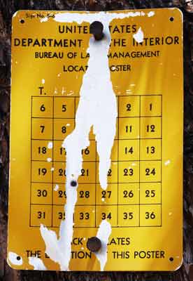
Township Poster 6 miles X 6 miles These posters are nailed to trees. A rusty nail shows the location of the tree as the corner of sections 20, 21, 28, and 29. |
|
Subdivisions of Sections
Sections could then be divided in quarters and further divided into quarters of quarters. These were the smallest divisions that could be described using the Public Land Survey System. See the dividing and numbering scheme below:
| Subdivisions of Sections | ||
|---|---|---|
| NW1/4 of NW1/4 40 Acres |
NE1/4 of NW1/4 40 Acres |
East Half E1/2 320 Acres |
| South Half of NW1/4 80 Acres |
||
| South West Quarter SW1/4 160 Acres |
||
| 1/4 Mile | 1/4 Mile | ← 1/2 Mile → |
|
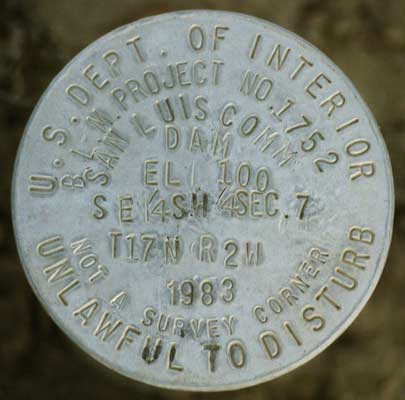
This marker shows the location of a dam as being in the southeast quarter of the southwest quarter of section 7 of T17N R2W. |
|
Section Poster
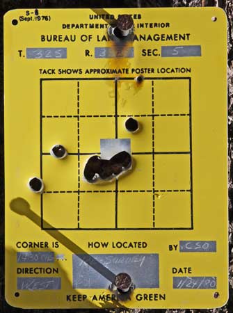
1 Mile X 1 Mile The nail shows this poster is 1/3 of a mile west of the northeast corner of section 5. A scratched X west of the nail at the middle of the north border of section 5 is the location of the monument the poster was installed to identify. These posters are often readable even after vandals have shot or wrinkled them. |
|
Aliquot Part, Or Description of a Land Parcel
The proper way of describing parcels in the system is to proceed from the smallest piece to the larger pieces in order with a terse description:
| SE1/4 NE1/4 S13 T2NR15E MDM |
| The South East Quarter of the North East Quarter of Section 13 of Township 2 North Range 15 East of the Mount Diablo Meridian |
Oddly Shaped Land Sections
Although the system is designed to parcel out land in square, easy to document pieces, weirdly shaped PLSS Sections occur for a number of reasons.
Convergence of Meridians
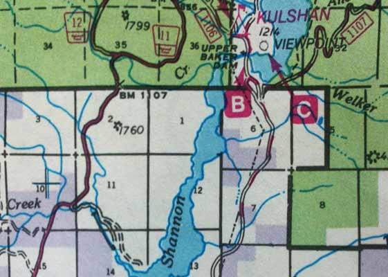
Meridians, or north - south lines, are closer together near the north or south poles than near the equator. To make the sections of townships line up with each others, some adjustment must be made. The surveyors started in the southeast corner of each township, and made all sections exactly one square mile, except those along the north and west sides. (1, 2, 3, 4, 5, 6, 7, 18, 19, 30, and 31) These sections may be a little more or less than one mile long to make the townships line up nicely. The area would, of course, be affected.
| Township 37 North Range 7 East |
Township 37 North Range 8 East |
|||
|---|---|---|---|---|
|
||||
| Township 36 North Range 7 East |
Township 36 North Range 8 East |
|||
|
||||
|
Note that the eastern boundary of T37N R8E Section 32 is tilted; 32 is not square. There are several section lines that do not line up. Some sections are rectangular, but not square. Land is owned in quarter quarter sections. Mount Baker-Snoqualmie National Forest Map Willamette Meridian |
||||
Surveying Errors
In the old days, these surveys were made by guys with 66 foot long chains and compasses. As hikers, we can well imagine how difficult it was to trace a line, for example, due west down a steep slope and over loose rocks and fallen trees, all the while maintaining perfect direction and distance measurements. Errors crept in once in a while.
Fraud
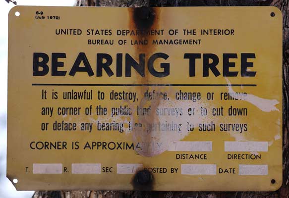
Once the corners between the sections were found, monuments (For example, a pile of rocks or a bronze marker directly on the point) and witnesses (For example, a marker on a nearby tree (Bearing Tree), which is easier to find than the monument, and tells where the monument or corner is) were installed. If someone wanted their plot of land to be bigger, they might move the marker. This not only cheated their neighbor out of some land, but also screwed up any survey that later came back to the marker as starting place. (This is why many monuments and witnesses have a criminal penalty for tampering stamped into them.)
|
$250 Dollar Fine or Imprisonment for Disturbing this Mark Geodetic or Triangulation Marker - No PLSS Location Code |
The Concept of Original Survey
Unless it is found to be deliberately fraudulent, the first survey of a piece of land is considered legally binding and valid. Thus, if a new parcel of land is surveyed from a monument which is misplaced due to error or fraud, and new monuments are set up in the new parcel, they remain valid forever. Obviously, they will not line up nicely with other monuments and corners outside the area where the error occurred.
Non-Rectangular Sections
Connecting these offset corners and monuments will result in non-square or non-rectangular parcels.
Effects on Hikers
Navigating using PLSS
When a hiker finds a monument, poster, or anything else with a PLSS coded location, it tells him exactly where he is. If his maps show the section grids and numbers, he can locate himself on the map. Provided that the hiker knows within 2 or 3 miles where he is already, it is usually not necessary to use the Township and Range information; the location within a one square mile section is adequate.
Chatting with Locals
Oftentimes, when I've been chatting with ranchers, they might say that they own and live on a half section and lease 4 sections for grazing. Right away, I know they live on 320 acres, and lease another 2560. If they mention they live about a mile west, I might be able to see on the map the half section of privately owned land. Or if they say the sections they lease are 2, 3, 10, and 11, I know exactly what land they are talking about. I've found that I can have some very interesting and enlightening conversations with local ranchers, foresters, miners, etcetera, if I show that I understand and care about what they are saying.
Other Survey Information
The surveyors parceling off the land were often asked to take many other notes. These can be used today to understand the historic condition of the land. For example, surveyors often noted the species and diameters of bearing or witness trees, and trees along survey lines, intersections of survey lines with natural features like streams, ridges, cliffs, fields, forests, meadows, etcetera, the composition of survey mounds and soils, water springs, lakes, ponds, structures, valuable minerals and mines, roads and trails, rapids and waterfalls, magnetic declination, etcetera. Some of this information has been passed from map to map and still informs hikers today.
 This exploratory well casing pipe is marked with its location, Section 8, Township 17 North, Range 2 West. |
Railroad Land Grants
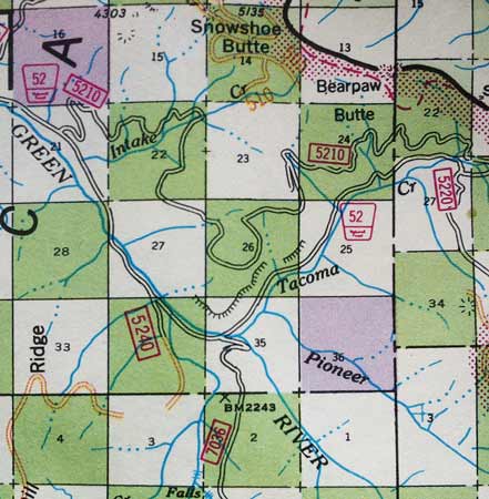
In order to encourage the building of railroads, the government several times granted half the land within a specified distance of each mile of railroad. For example, the Pacific Railroad Act of 1862, signed by President Abraham Lincoln, granted 10 square miles of land along each mile of rail built. This was done by granting alternate sections of land to the railroad in a checkerboard fashion. In this way, both the government and the railroad would own some of the land made more valuable by proximity to the rail line. This checkerboard pattern can clearly be seen on land ownership maps near rail lines built in the late 1800's. Along the PCT at Snoqualmie Pass, as an example, hikers see the weird checkerboard of healthy forest and grossly abused timberland with clearcuts, third growth, etcetera, which has resulted from the Railroad Land Grants.
| Township 20 North Range 11 East |
T20N R12E |
Note railroad checkerboard pattern and sections 16 and 36 set aside for schools. R12E is missing western sections 6, 5, 4, and part of 3 (Half of Township). Section 3 is 1½ miles tall. Mount Baker-Snoqualmie National Forest Map Willamette Meridian
|
|||
|---|---|---|---|---|---|
|
|||||
| Township 19 North Range 11 East |
T19N R12E |
||||
School Land Grants
Starting in 1785, so that schools could be funded, section 16, and later also 36, were set aside. Sometimes this was ignored, and sometimes the land was sold off, but even today there are areas where sections 16 and/or 36 in every township are state land and have different rules for their use by ranchers and hikers than the surrounding lands.
Roads
Sometimes roads are built on section boundaries. A look at the map might show an incredibly straight, very long road, or straight parallel roads separated by a mile, half mile, or etcetera. Sometimes the roads take right angles along section boundaries even when the topography wouldn't suggest it. Hiking across a long, straight road in a cardinal direction is a clue to where you are.
Homesteading
The lower 40, 40 acres and a mule, and many other references to 40 acres recall the time of small farms in the east, where the land was lush enough that a 40 acre farm could support a family. 40 acres is a quarter quarter section. Per the Homestead Act of 1862, western lands were granted in quarter sections (160 acres). Once the best lands were distributed the Homestead Act was amended to allow homesteads of a full section (640 acres). This allowed lesser quality lands, not good enough for farming, to be used for ranching.
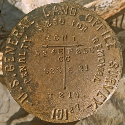
| This marker shows a location of the intersection of the Montana - Idaho border and the meridian between Range 24 East Section 36 and Range 25 East Section 31, both in Township 21 North. |
|
Finding things by PLSS Description
Often, if you research old mines, historic sites, and etcetera along trails, the location descriptions in books or on the internet will be by PLSS. Sometimes, important trail navigation clues are too. Below are descriptions of the locations of water cache boxes along the Continental Divide Trail in the Bootheel of New Mexico:
| CDT Water Cache Box Locations, Bootheel of New Mexico | |||
|---|---|---|---|
| Description | PLSS Description | Longitude | Latitude |
|
South of Lordsburg near Animas Road |
T023S R018W Sec 31 | 108°44'30.015"W | 32°15'46.171"N |
|
Southwest of Separ near NM Highway 113 |
T025S R017W Sec 35 | 108°33'23.471"W | 32°4'49.602"N |
|
West of Hachita near NM Highway 9 |
T027S R016W Sec 14 | 108°26'23.489"W | 31°57'54.711"N |
|
South of Hachita near NM Highway 81 |
T030S R015W Sec 6 | 108°24'38.742"W | 31°44'2.044"N |
|
Northern end of Sheridan Canyon near the Big Hatchet Wilderness Study Area |
T031S R015W Sec 13 | 108°18'47.944"W | 31°36'44.65"N |
Junction with Trail # 37E01
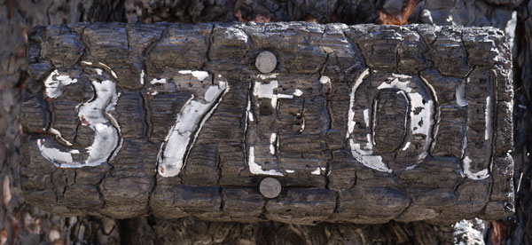
US Forest Service Route Numbering System
Sometimes US Forest Service trails and routes are numbered by the following system. Sometimes not:
| 17N24.1 or 17N24C | |
| 17N: | 17N may be the township in which the north end of a road, or the Range in which a trail is located. Thus, 17 might be replaced by a 1 or 2 digit number, and N might be replaced by S for roads, or E or W for trails. Sometimes the letter is not shown, for example: 1724.1. Obviously, two roads starting in the same township cannot have the same number. Sometimes the first digits are a forest highway number, and have nothing to do with the PLSS designations. Road 17 would be a fairly important forest route, probably well maintained. |
|---|---|
| 24: | If there are a number of smaller roads branching off a larger road, the second set of digits may number them sequentially from east to west, or for trails, from north to south. But keep in mind that logging roads are built and closed all the time, etcetera. Road 17N24 probably branches off Road 17. |
| .1 or C: | If there are yet more roads branching off the branches, some system of letters or decimal numbers may be used for the branches. Road 17N24.1 or 17N24C branches off Road 17N24. |
| 17N24C | If the letters are arranged horizontally on a road sign or map, the road may be driveable by passenger cars. |
| 1 7 N 2 4 C |
If the letters are arranged vertically on a post or stake, the road or trail may be passable only by foot, four wheel drive, etcetera. |
This road numbering system is not always used, and not always followed uniformly, but it might give you some insight about connections between various trails and roads. You should check your intuition on maps if you don't want to get lost.