
|
North Conecuh Trail North is Up Source: USGS 2018 7½' Quadrangle Carolina January 2020 |
 Open Pond & South Conecuh Trail North is Up Source: USGS 2018 7½' Quadrangle Wing January 2020 |
Visiting Civilian Conservation Corps Sites
Any long time American hiker has run across CCC built projects. Whether something spectacular like the Timberline Lodge along the PCT in Oregon on Mount Hood, featured the movie 'The Shining', or miles of stone retaining walls on a lonely stretch of very well built trail, to see such labor intensive and excellent workmanship standing the test of time is awe inspiring. Many long distance hikers have told me of their love for Parkitecture, or the impressive rustic buildings left over from the CCC and other historic movements. They go miles out of their way to eat in monumental CCC or Railroad lodges in National and State Parks, and to see all the less impressive structures too. This page is my attempt to help hikers of the Alabama Pinhoti and Eastern Continental Trails visit several CCC and related sites and understand a bit of the history of each site.
A Delaying Tactic
Those hiking the Eastern Continental Trail or an extended Great Eastern Trail from the south of Florida on up to Canada must somehow deal with a mismatch in the ideal hiking seasons of Florida and the best seasons further north. The Florida National Scenic Trail is often flooded. The driest season centers around January and February. These months are also the least buggy, a serious consideration in the swamps of Florida. But the roadwalk across southern Alabama will probably be accomplished very quickly, putting one on the mountains of the Pinhoti Trail and Talladega National Forest in the very early spring, when it will be quite cold. Slowing down along the Conecuh and Pinhoti Trails might make the spring hiking on the Pinhoti, Benton MacKaye, and Appalachian (ECT) or Pinhoti and Cumberland Trails (GET) much warmer and more pleasant...
| CCC | Civilian Conservation Corps |
|---|---|
| ECW | Emergency Conservation Work - Same as CCC |
| YCC | Youth Conservation Corps |
Size and Speed of CCC buildup
The size of the CCC and the speed with which it came to be, and then to disappear, is breathtaking.
• On March 31, 1933, the US Congress passed the Emergency Conservation Work Act, creating the Civilian Conservation Corps.
• In April 1933 Alabama's State Forester proposed 20,000 men building roads to Cheaha State Park, to Flagg Mountain, and much more in all 13 state forests and 7 state parks.
• By December of 1933, 315,000 men were in the CCC nationwide.
• By September of 1934, 850,000 people had been employed by the CCC nationwide at a cost of $443 million.
• By October of 1934, the CCC in Alabama had spent over 10,000 man days on tree nurseries and planting, built 3,186 miles of firebreaks, 103 miles of telephone lines and 603 miles of truck trails, reduced fire hazard on 8,172 acres, and fought forest fires for 22,779 man days.
• In the early days of World War II, it just disappeared as its members either got jobs producing war materiel, or joined the armed forces.
• It officially ended July 1, 1942.
• It started and finished in less than 10 years.
What is Left to be Seen Today
The vast majority of the work done by the CCC was day to day clean-up, maintenance, brush clearing, etcetera. It left no enduring mark on our wild lands. But if you are visiting government lands, whether local, state, or national, and you see improvements which look incredibly labor intensive, like walls or buildings made of millions of local stones, chances are they were built by the CCC. Though this was a small part of their work, these structures are so rugged that they seem able to last forever.
CCC Camps
Although the CCC worked during the day for various land management agencies, all other aspects were run by the United States Army. The ruins of the camps there the CCC members actually lived are usually reminiscent of army bases, with barrack building foundations on a retangular grid, and a few other foundations for buildings. At you wander an overgrown camp seeing foundations, think about what a military base looks like today, and interpreting the ruins won't be too difficult.
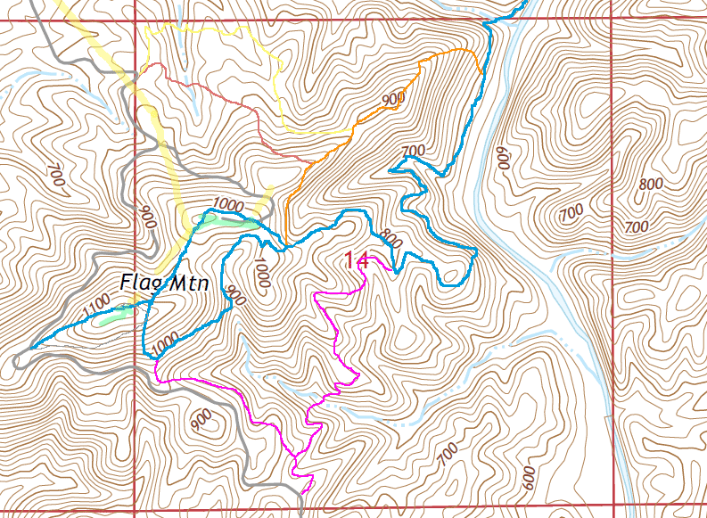
Alabama Trail, Conecuh Trail, Conecuh National Forest
On November 17-19, 2006, I day hiked the Alabama Trail and the Conecuh Trail in the Conecuh NF. On March 9 and 10, 2016, Mother Nature's Son and I day hiked the Conecuh Trail.
The Conecuh Trail as a Scenic Option
For those connecting the Florida Trail to the Pinhoti Trail in as fast a road walk as possible, the dirt roads of the Alabama Trail in the Conecuh NF are a quick and reasonably pleasant walk. However, the 20 mile Conecuh Trail is mostly off dirt roads, is quieter and more pleasant, and visits historic CCC sites. Some parts of the Conecuh Trail directly parallel the faster dirt road walks but don't add many miles or hours to the journey, while others would classify as side hikes.
Cunecuh National Forest
National Forests come into existence in various ways. The 1911 Weeks Act authorized the US Forest Service to buy land to protect the headwaters of eastern US rivers. The 1924 Clarke-McNary Act simplified purchase of land within authorized national forest boundaries, and simplified cooperation with states and private forest owners. In January of 1935, the National Forest Reserve Commission established the Conecuh Purchase Unit. On July 17, 1936, 54,177 acres (~85 square miles) of clear cut and burned lands were proclaimed by the president to be the Conecuh National Forest.
Why National Forests Bought Stripped Wood Lands
At the time, it was common practice for lumber companies to buy as much forested land in an area as possible, cut down every tree that could possibly be sold, plus any in the way, and abandon the stripped lands. The lands would eventually revert to the counties because the taxes were usually not paid. This was financially devastating to the counties and ecologically devastating to the lands. Furthermore, without trees, and with poorly built roads and skid trails going everywhere, the lands would severely erode. The silt would fill creek beds for miles downstream, and pollute the drinking water for cities drawing their water from downstream rivers. Land without trees and shrubs sheds rainwater more quickly, potentially causing flooding downstream. To address these problems, national and state forests often bought these lands cheap, and tried to replant them.
CCC Company 3474, Camp F-9, Open Pond
Open Pond is at the south end of the Conecuh Trail. See maps. In February of 1936, African American Junior Company 3474 came from Fort McClellan and established their 210 man camp at Open Pond. There is a restored 100' CCC Fire Tower. A 12x12 foot cab allowed 24 hour occupation. The Open Pond area also has a picnic shelter rebuilt in 2001 but reminiscent of the 1938 CCC shelter. The CCC camp was less than a half mile south.
| January 1937: | 22,000 trees from an ECW nursery in Augusta, Mississippi are planted on the first day. |
|---|---|
| February 1937: | 1,000 acres at Blue Pond planted at 6x8 foot intervals with 250,000 Longleaf and 576,000 Slash Pines with 90% survival rate. |
| February 1938: | 2,500,000 Pine Trees Planted sine November 1937. |
| 1941: | 3,335 acres planted with Pine Trees. |
The Conecuh Trail
Sources: Conecuh National Forest Website and Personal Experience
The 20 mile Conecuh Trail winds visits swampy areas, cypress domes, sinkholes, and long leaf pine on sand hills. There are many insectivorous plants; Think about bringing some sort of guide. The trail was built by the Youth Conservation Corps starting in 1976. The Conecuh ecosystems are similar to those of the Florida Panhandle, but differences in fire regime and land management decisions make the forest here a bit different. The south loop of the Conecuh Trail leads to Blue Springs, a large natural spring of clear, icy blue water, and to historic CCC areas.
Mr Bray of the CCC Open Pond Camp
Mr Bray remembers that in the Great Depression, no timber was left; it had all been cut by timber companies. No Turkeys, deer, or other wildlife survived the lumbering. He and the other CCC members replanted the Conecuh National Forest, and fenced the new plantations from feral hogs. They built and staffed fire towers at Open Pond, Dixie, and Parker Springs. He remembered as a school child rangers showing films of wildlife and assuring that with good care of the woods, the wildlife would return. It did. He considers President Roosevelt a hero for promising and delivering restored forests and wildlife.
| Some Locations along the Conecuh National Recreation Trail | |||
|---|---|---|---|
| Name | Latitude | Longitude | Comment |
| GumPondTH +Conecuh 137 FR332 | 31.153768 | -86.573719 | - |
| +Conecuh 325 eastOfNelliePonds | 31.157629 | -86.552538 | - |
| +Road Conecuh EndDetour | 31.152213 | -86.553962 | - |
| +RidgeRoad Conecuh | 31.141260 | -86.558901 | Aka HeadquartersCampRoad |
| +Y Conecuh 335 333 | 31.131058 | -86.556432 | +Yellow Blazed Alabama Trail | +Conecuh/Alabama 137 FR355 | 31.124725 | -86.570744 | Sign TroutPond2.5 MossyPond3 |
| +Conecuh 355 AlabamaTurnsSouth | 31.129113 | -86.583328 | CrossMoccasinBranch |
| +Conecuh 330f | 31.128792 | -86.590068 | - |
| +Unblazed2trackNorth Conecuh | 31.132622 | -86.596348 | - |
| +Conecuh 330 330d | 31.137025 | -86.601548 | - |
| Conecuh PicnicShelterBelow | 31.140757 | -86.599884 | - |
| +330 Conecuh | 31.139825 | -86.597523 | - |
| +Conecuh 348f BuckPondDock | 31.089605 | -86.543468 | - |
| Y Conecuh Trail | 31.090001 | -86.538816 | OpenPondRecArea.5 BlueLakeRecArea3 BlueSpring2.5 |
| Y ConecuhNRT | 31.092684 | -86.538094 | OpenPondRecArea.75 BlueSpring1.75 BluePondRecArea3 |
| Y Conecuh TrToNaturalSprings.2 | 31.094880 | -86.538701 | - |
| +Conecuh CR24 | 31.102018 | -86.544396 | BlueSpring3 OpenPond1.5 BlueLake2 NelliePond5 |
| ConecuhTr AccessTrBlueLake/Pnd | 31.116649 | -86.555831 | - |
| +Conecuh BlueSpringSpur | 31.090480 | -86.515375 | - |
| BlueSpring | 31.091013 | -86.514707 | - |
| Name | Latitude | Longitude | Comment |
| ||
|
Sunday, March 13, 2016
John and I climbed the Smith Mountain Fire Tower near Lake Martin. The tower had recently been rebuilt by volunteers so the public could climb it. The views were great.
John - Is this a reasonable detour for ECT hikers?
Cabins 1, 2: Most wood has rotted away. Chimneys, Foundations, Iron etcetera remain. There is a nice tent platform for camping. Cabin 3 (Signed 4) is the workshop and home of the Flagg Mountain caretaker, Nimblewill Nomad. Cabins 4, 5, and 7 (Signed 3, 2, ?, Respectively) are available to stay in on a donation basis. They are nice, rustic, weatherproof, and have electricity and fireplace. There is a pit toilet nearby. Between Cabin 6 and 5 are a bandstand / social area, the pumphouse, and the foundation of the old water tower. A pit toilet is north of cabins 4 and 5. Cabin 6 (Signed Ranger's Cabin) is set up as a visitor center. There are several rooms. If it is a cold, miserable day, you should sit by the fire a while. Chances are either a local or some super long distance hiker or trail maintainer will wander by and tell some tales. There is plenty of information to peruse. There is a fridge, electricity, etcetera. The Tower itself is closed because the wooden stairs have rotted to the point of being dangerous. But there is a nice cabin room on the west side with reading material, and a picnic shelter on the east side. No doubt the stairs will eventually be replaced, and a visit will give a great view and experience much like the similar tower at Cheaha Peak. The view north from Flagg Mountain includes some of the ridgeline on which the Pinhoti Trail runs, and Cheaha Mountain, a highlight of the Pinhoti. |
| Below: Flagg Mountain Trail System | ||||||||
|---|---|---|---|---|---|---|---|---|
| ↖ To CR55 |
|
|||||||
|
| |||||||
|
||||||||
| Above: Flagg Mountain Trail System | ||||||||
The Flagg Mountain Trail System
Note that there are a half dozen trails within one square mile. I have never visited Flagg Mountain or discussed Flagg Mountain without being told that one trail routing has just changed and another will be changed right away. So the trails won't be exactly like the map above. But if you have a good sense of direction and a dose of doubt as to whether the trail you're on is taking you where you want to go, this map will help you figure it out.
At upper left, at a crook in the CCC road near a power line cut, are two trails we built when access to the top of Flagg Mountain was still forbidden. At this Old Flagg Trailhead a logbook indicates hikers have been visiting since 2006. A few indicate they felt totally lost, and a few express disappointment that the trails did not access the (then forbidden) cabins and tower.
On middle left, the easiest walk to the tower is from a bend in the CCC Camp Road. The historic tower complex is interesting, and though the tower has not yet been made safe to climb, the views from the clearing are good. There is a modern steel antenna tower too.
At bottom center is a picnic shelter, kiosk, and parking built later than the Old Flagg Trailhead but before people were allowed to visit the cabins and tower. I'll refer to this as the Old Pinhoti Terminus.
 Pinhoti Trail Southern Terminus Thursday, May 19, 2016 |
| Although some claim that Flagg Mountain, at 1,152' is the southernmost Appalachian Peak over 1,000' above sea level, and therefore ought to be the Pinhoti or Appalachian Trail Southern Terminus, there is a higher peak to the south and east in Georgia (Dowdell's Knob, Pine Mountain, 1,395'). |
Alabama State Park System History
On September 27, 1927, a State Land Act was passed authorizing Alabama to develop a state park system. There wasn't a lot of money to buy lands, but by 1933 there were 11 Alabama state parks including Weogufka (with Flagg Mountain) and Cheaha. By 1939, there were 14 parks, but 5 were deemed high priority including Cheaha, while Weogufka seemed less important and was to be operated as a state forest.
National Park Service as Advisor
On June 23, 1936, the US Congress passed the Park, Parkway, and Recreational Study Act. Under this act, the National Park Service began to advise state, county, and local parks. This is why CCC built projects nationwide and whether local, state, or national, were developed with a similar look and feel. The rustic parkitecture look of local stone and log buildings, and park layouts following the lay of the land spread everywhere.
Civilian Conservation Corps as Builder
As mentioned earlier, there wasn't a lot of money to be spent at the state and local level on parks. But the point of the CCC was to put unemployed people to paying work, to give those people valuable skills so they could get jobs elsewhere, and to build things of value to the country. And the CCC tried not to spend much on materials. Whereever possible they used local stone they dug up themselves, local logs they harvested themselves, etcetera. Even hardware like hinges and fireplace andirons was built by hand from junk railroad rails, pipes, etcetera. So if any government agency wanted a park and had the land, the CCC could and did build it for almost free. In addition to well planned, very popular parks like Cheaha, many other parks were built which never were popular enough to attract enough user fees or public funds to maintain themselves. Flagg Mountain is one example of many developments which were almost forgotten in World War II and sort of faded away.
Weogufka State Park Flagg Mountain
Company 260 of Camp SP-4 at Weogufka, by the end of 1934, had completed 40% of the 52' stone observation tower; It was already popular with visitors. A caretaker's house of halved logs and 4 more visitor cabins were under construction. 4 miles of trails had been built. By January 1935, CCC Camp Road was open but not surfaced and there were no guard rails (still waiting on the guard rails.) The visitor cabins are stone up to the windows. The workers were learning masonry one by one, while trucking sand 18 miles and stone 10 miles. (Some say all the stone for all the buildings came from Cheaha State Park.) The camp was 2½ miles from the work site. By June 1935 a dam had been built and the west cabin, of 11" longleaf logs, was done but for the window shutters. Most other cabins were nearing completion. By September 1935, Company 4498 was on site, and a Coast and Geodetic Survey Bench Mark had been placed in the tower floor. The tower exterior wood bracing had been decoratively burned with a blowtorch. The museum and picnic pavilion attached to the tower were done. Materials for a 4 mile telephone line between the park and camp were on site.
The tower was designed by WW Young, an architect and engineer for the department of interior.
CCC Camp S4, where the CCC lived, had some large barracks, a mess hall, officers quarters, and several small buidlings. It was in Weogufka at the base of Flagg Mountain. Construction began November 2, 1933 and was done by January 1934. The camp buildings were sold and torn down for lumber. Bob McCucheon built several chicken houses and his home with it.
The area was considered a park and had rangers until about 1940, when it was turned over to the forestry commision, which had little use for it other than as a worksite and fire lookout. 7 cabins and a tower didn't make much of a park, and with the war and no CCC, the planned developments by the creek were never to happen. The cabins had been fully furnished, but the linens, dishes, etcetera were sent to other parks. With little budget and no real use for so many cabins, the forestry commision left the cabins to decay.
Tower Structure Over Time
After a lightning strike, former wood diagonal beams embeddded in the masonry on the upper portion of the tower burned, and were replaced by more stone masonry, leaving the diagonal pattern we see today. Inside the tower, wood rotted, leaving the stairs and cabin floor unsafe. The cab floor and the stair treads from the lower two flights were removed to prevent climbing.
Tower Use Over Time
Although the tower was built for use by visitors to see the view, the park never really opened to the public, and it was used as a fire lookout until 1989 by the Alabama Forestry Department. It has since been closed. It is on the National Historic Lookout Register, #250. Among the organizers for Flagg Mountain, replacing the stairs and floors so the tower can be used by the public is the highest priority. But getting an approved plan and money will take time. Soon enough, the Flagg Tower will be open to the public for climbing and gazing at the view.
Building a bathroom for visitor use near the cabins is also a very high priority.
Kate Prater, Flagg Mountain Lookout, 1950-1988
Kate Prater was the radio operator and fire lookout in the Flagg Mountain Lookout Tower from October 1, 1950, until her retirement in 1988. (There were other earlier lookouts, starting with the CCC.) She worked for the Alabama Forestry Commission but also relayed radio messages for other state agencies. She once crossed a fire 45 miles away and on very clear days could see even more distant towns. (Crossing means that she and the lookout at another tower each gave precise compass directions to the fire so the position could be plotted on a map.) After years of observing, she could distinguish between the smoke from a moonshine still and a wild fire. And she left the shiners alone; If not, they might have set wild fires to cover their work! October - April was the fire season, with most fires in March and April. She sometimes worked 24 hours a day, 7 days a week, until fires were out.
When she started in 1950, she was a temp. The starting salary was $90/month, the work 7 days a week. After a couple of months, a guy with a proper radio license replaced her. He lasted about a week, and she kept the job for the next 38 years. She didn't find it lonely or boring; she could read, sew, etcetera when nothing was going on.
She left the tower during electrical storms. In separate events, lightning blew a window casing apart, caught the roof rafters afire, burned the diagonal wood bracing on the outside of the tower (Now filled with stone masonry in the distinctive diagonal pattern.), and blew out a radio. She said that the tower could predict weather; The stone walls would condense water 1-1½ days before the rain. And snakes liked the cool, damp, and dark in the tower; She often found them louging on the stairs.
In Kate's era the ranger cabin was used as an office. By the time she retired, most fire watching was done by aircraft, which required less people, and also could circle a fire and advise people on the ground. And there were more people living in the woods to call fires in. So few towers are staffed anymore. In 1985, there were only 6 staffed towers in Alabama (5 staffed by women!) The gates were locked and no one could visit after Kate retired in 1989.
Kate said Flagg Mountain got its name because General Jackson Posted his flag there. It makes some kind of sense to post the flag on the highest mountain around.
WR "Pete" McElrath: In 1953 Coosa County built a road from CCC Camp Road directly to the cabins, as the road between the Tower and Cabins was too steep. Pete handled the dynamite and was once hit by a rock, with no real injury. He enjoyed the Flagg Mountain job.
Coosa County Cooperators, 1997 - 2017
From 1997-2017 a group of locals, the Coosa County Cooperators, had a lease over all Flagg Mountain structures. They installed good roofs on the tower and the five standing cabins, and made repairs to keep the buildings standing. Without them, most of the buildings would probably have rotted away and fallen, much like the two northernmost cabins, which today are just the stone work: chimneys and foundations. But they were not able to keep a caretaker on the mountain, a state requirement for people to visit the tower and cabins. Many local people had great family memories of time spent on the mountain, and wanted to be allowed to visit.
Alabama Hiking Trail Society, 2017 - ?
Since then, the Alabama Hiking Trail Society took over the lease, and Nimblewill Nomad has taken the role of the caretaker. So long as he is on site, people can visit. He and others are in a continuous state of fixing up the historic buildings. It's getting to be a nicer and nicer place all the time.
Old Longleaf Pines
Longleaf Pines on Flagg Mountain have been cored to determine their age. One was 340 years old, and another is 390 years old and still living, the oldest in Alabama.
 A Stone CCC Culvert October 18, 2019 |
| In the stub road west from the tower to CCC Camp Road. |
 A Stone CCC Culvert October 18, 2019 |
| In the stub road west from the tower to CCC Camp Road. |
 Flagg Tower from South East October 18, 2019 |
 Flagg Tower from North October 18, 2019 |
 Flagg Tower from West October 18, 2019 |
 Flagg Tower from Northeast October 18, 2019 |
 Flagg Tower Brace Braces and Pegs used in Picnic Shelter Structure October 18, 2019 |
 2 Round and 1 Square Peg, Flagg Picnic Shelter October 18, 2019 |
 Flagg Tower Fireplace October 18, 2019 |
 Flagg Tower Fireplace Andirons Made from Pipes and Railroad Rails October 18, 2019 |
 Flagg Tower Bench and Table October 18, 2019 |
 Flagg Tower Power Panel October 18, 2019 |
 Flagg Tower Stairs October 18, 2019 |

Flagg Tower from North / Entrance Road
Thursday, January 26, 2017
 Flagg Telephone Wire October 18, 2019 |
| This cable, buried in the road between the tower and the ranger cabin, probably once connected telephones in the tower with those in the cabins. |
 Flagg Hollow Cabin from South West October 18, 2019 |
 Flagg Hollow Cabin from West October 18, 2019 |
 Flagg Hollow Cabin from North October 18, 2019 |

|

|
|
Log Wall Joint Style of Cabin in Hollow October 18, 2019 | |
|---|---|
 Ceiling October 18, 2019 |
| Note doubled rafters and replaced roof boards. Note nice panelling over log walls. |
 Dowelled Door October 18, 2019 |
 Door Bolt October 18, 2019 |
| Note arc welding spatter. The bolt and door were probably replaced after the CCC era. |
 Fireplace October 18, 2019 |
| Note red brick in oven and crack above fireplace keystone. |
 Electric Meter October 18, 2019 | ||||||||||||||||
| ||||||||||||||||
 Electric Meter October 18, 2019 |
 Electric Meter October 18, 2019 |
 Electric Meter October 18, 2019 |
 Interior Lamp Base October 18, 2019 |
 Ranger's Cabin from South East October 18, 2019 |
 The Ranger Cabin sign. The 2019 Flagg Mountain Strategic Plan refers to it as #6.
|
 Joint Detail |
 Log Cabin Joint Detail |
| Note the insulator bracket, probably left over from a long ago open wire telephone line to the tower and distant headquaters. October 18, 2019 | |
 Rotting Cabin Logs October 18, 2019 Note peeling wood and insect tunnels. |
 Stairs on the back / west side of the Ranger Cabin October 18, 2019 |
 Crawlspace Vent October 18, 2019 |
 Hinge October 18, 2019 |
 Hinge October 18, 2019 |
 Hinge October 18, 2019 |
 Hinge October 18, 2019 |
 Square Spike in a Square Hole It is very difficult to cut a tidy square hole. October 18, 2019 |
 Complex Woodwork October 18, 2019 See the table photo in the tower. Part of a picnic table? |
 Lockset October 18, 2019 |
 Ladle October 18, 2019 |
 Swing October 18, 2019 |
 Witness Mark, WEOGUFKA 1930 1947 October 18, 2019 |
| This Witness Marker is near the Flagg Mountain Ranger Cabin. Having two stamped years is atypical. I was not able to find the Triangulation Point or other Witness Markers nearby. This is not the highest point nearby, so it is also atypical to have triangulation markers. Perhaps it points to the marker in the floor of the Flagg Mountain Tower. |
 Nimblewill Nomad, Flagg Mountain Ranger CCC Cabin Thursday, December 22, 2016 |
| Nimblewill Nomad is the caretaker at Flagg Mountain. He is fixing up whatever he can, bit by bit. I've seen him remove, clean, paint, and reinstall every bit of rusty hardware in the cabins. The paint he has just put on the ceiling looks great! He is holding one of the 2x4 signs I carved and filled with paint. |
 Skip, Mr Leave No Trace, Flagg Mountain Saturday, November 5, 2016 |
| Skip is a regular Leave No Trace presenter at local gatherings of hikers. |
 Nest in the Flagg Mountain Pump House October 18, 2019 |
I've seen both historic photos of a wood barrel style water tower and of a stone water tower.
 New Flagg Mountain Privy, Sale |
| This new outhouse was built over the historic vault. Like all Flagg structures, Nimblewill has incorporated as much original hardware as he could. |
| ||||
 Flagg Mountain CCC Cabins Monday, March 21, 2016 |
 West Cabin from South East October 18, 2019 |
 West Cabin from East October 18, 2019 |
|
Page 111 of Bob Pasquill's book has a photo which shows nearly this view but with a stone tower in the background. Its caption reads: "Caretaker's house with observation tower in background, Weogufka State Park. Structures built by Company 260, Camp SP-4. Photo courtesy of USDA Forest Service." Actually, it is probably the stone water tower in the background. The foundation and short walls still remain of the water tower. In talking with many people, I have never heard of this cabin being the caretaker's. It is usually spoken of as a visitor's cabin. But is has its own bathroom, and not all do. Perhaps... |
 West Cabin from North West October 18, 2019 |
 | The West Cabin is signed Number 2, but the 2019 Flagg Mountain Strategic Plan refers to it as #5. |
 Fireplace in West Cabin October 18, 2019 |
 West Cabin Log Work October 18, 2019 |
| There are different styles of fitting logs for each cabin. |

|

|

|
| Doors of the West Cabin October 18, 2019 | ||
|---|---|---|
 West Cabin Hinge October 18, 2019 |
 Center Cabin from South West October 18, 2019 |

|
The Center Cabin is signed Number 3, but the 2019 Flagg Mountain Strategic Plan refers to it as #4. |
 Center Cabin Porch from South East October 18, 2019 |
 Center Cabin Fireplace October 18, 2019 |
 Center Cabin Log Work Detail October 18, 2019 |
 The East Cabin is signed Number 4, but the 2019 Flagg Mountain Strategic Plan refers to it as #3. Because in general cabins numbers are not consistant from source to source, I will not use numers to identify them.
|

|
 Mortar Chinking, Dovward Church |
| Note nails securing mortar chinking. Dovward Church met in this cabin long ago. October 18, 2019 |
 Rotted Logs in the East Wall Looking South October 18, 2019 |
| Replacing these will be a big project. |
 Rot and Repair of Roof October 18, 2019 |
| Note blackening of original roof boards and replacement with plywood. Note 2x4 buddy boards on rafters. At left, note lime from mortar chinking has leached and is covering log wall. |

|

|
| Weathered Exterior Electical Wire October 18, 2019 | |
|---|---|
 Wiring Above Meter Socket October 18, 2019 |
 Electric Meter Socket October 18, 2019 |
| Note right side grounded and otherwise disconnected: 110 Volt Service. Note contacts cleaner on left. Aluminum tag at top has raised number 11041974. |
 Insulator October 18, 2019 |
| Note log end discoloration possibly due to leaching of Galvanizing zinc. |
 Ceiling Lamp Connection October 18, 2019 |
 The Tree at Center was cored for age. October 18, 2019 |
| South of the East Cabin, the tree closest to the clearing was cored for age. |
 Core Hole October 18, 2019 |
| Core holes fill with sap and heal well soon after coring. |
 Foundations of a Cabin Ruin October 18, 2019 |
 Pipes at Cabin Ruins October 18, 2019 |
| Hardware can still be found around the 2 ruined cabins. |
 Tent Platform at Cabin Ruins October 18, 2019 |
| The hill with the 2 ruined cabins makes a nice, quiet campsite, and has a picnic table and tent platform. |
This CCC Camp Road bridge is over McCutchen Brook just upstream of where it joins Gold Brook and forms Finikochika Creek, which flows a few miles south and joins Weogufka Creek. It is between Flagg Mountain and Coosa County Road 55.
 CCC Road Wood Bridge Deck October 18, 2019 |
| Looking southeast. Note additional flat car bridge to right or southwest. The second bridge is blocked off but looks like it is occasionally used by ATVs. Perhaps it was installed when the wood decking was too old to use and hadn't yet been replaced. Note that to the right of the road is a mowed power line cut to Flagg Mountain. The ridge in the background is Flagg, to the southeast. |
 Erosion Under Bridge October 18, 2019 |
| Rain dripping between the road bridge deck boards created this pattern of trenches, mosses, and plants. |
 Brook and Bridge Piers Note weathering and missing chunks of Bridge Beam. October 18, 2019 |
 Bridge Piers October 18, 2019 |
Talladega National Forest History
The Talladega Purchase Unit was formed January 21, 1935. President Roosevelt proclaimed the Talladega National Forest July 17, 1936. It included a Talladega Ranger District from Sylacuagea to Cheaha State Park, and from the park to Piedmont, a Shoal Creek Ranger District. The idea was to purchase the Talladega mountain range land that was not suitable for farming. About 72% of this was cut, with the remainder mostly cut.
Sky Way Motor Way History
In addition to fire towers and phone lines connecting the towers and various administrative buildings, in 1935 Company 3477 of Heflin Camp F6 was to build a 75 mile Sky Way Motor Way between Sylacauga and Borden Springs. Today it is also known as dirt road FR600 in the south, then paved Scenic Highway 281, and in the north dirt road FR500. In June 1942, Company 3478 was to plant Bermuda Grass along ten miles of the Skyway, complete Coon Creek Bridge, and continue work on 6.1 miles of phone line from the Cheaha-McElderry Road and Talladega. But the Corps was disbanded July 1...
Sky Way Motor Way: Water and Better Views
Pinhoti thru hikers will often closely parallel and cross the Skyway. From Sylacauga to Adams Gap, where there is often little water on the Pinhoti, one can switch to FR600 for a short while and likely find water seeps. In drier times, following roads crossing the Pinhoti at gaps downhill will probably lead to water. Consult topographic maps to find close creek / road crossings. Sometimes following the Skyway will yield better views than following the Pinhoti...
 Map of Horn Mountain North is Up Bar is One Half Mile Source: USGS 2018 7½' Quadrangle Horn Mountain January 2020 |
The CCC Built the Horn Mountain Fire Tower
By July 1936, a 100' International Derrick & Equipment Company steel tower with a 7x7 steel cab on Horn Mountain had been completed by Company 3478 (Camp F7, Talladega). Telephone lines had been built between the Horn Mountain Tower, Camp F7, and Talladega. There were also radios at most sites. The forest service office was in Talladega City Hall.
In 1942, concrete boxes were planned for the cisterns at Horn, Horseblock, and Hollins Towers. But the Corps was disbanded July 1...
Later on Horn Mountain
The CCC built Horn Mountain fire tower is now fenced, closed to the public, and covered with in-use communications antennae. In the woods are the ruins of a once nice recreation area of the 1950s abd 60s: toilets, tables, etcetera. A picnic shelter originally built in 1957 was rebuilt in 2005 by the Timber Framers Guild. There are several stone built overlooks to the west and the foundation of the dwelling for the fire lookout. I've run into old timers who told me how nice the facilities were and that the road was good enough for family cars. They mention how many people loved it or worked on it, and how angry they would be if they saw it now. Today, you can stand in the silence and imagine the family picnic days in the overgrown ruins. It would be a great camp or lunch spot on a calm day with clear views. But the shelter is open on all sides, and would offer no protection from wind driven rain during storms. The dashed line is the Pinhoti Trail. You can access the top via the Power line cut, highlighted in yellow. Or you can switch to dirt road 600.1 as you approach the mountain. Chances are you'll see no cars. A reroute of the Pinhoti so it passes over the top is under consideration.
1957: There were "a picnic shelter, parking space, tables, fire places, toilets and foot trails."
1963: 5 tables, 2 benches, and a well were installed.
1964: More water infrastructure, including a stone encased drinking fountain added.
1969: The lookout's dwelling was removed.
1979: An 8x8 foot communications shed, a fence around the tower, and antennae were added.
1997: More antennea added to historic tower in lieu of new towers.
Circa 2020 Horn Mountain Fire Tower Restoration
The Talladega NF is planning to restore the tower for safety of employess accessing antennae, and to mitigate a new 2x2x60 foot tower about 15 meters from the historic tower. No historic buildings will be destroyed, but some trees may be cut. Thee will be new drawings, the stair treads will be refurbished, unused antennae and cables will be removed, the tower will be painted, and there will be interpretive signage.

View southwest from County Road 7 of Horn and Rebecca Mountains
The Pinhoti Trail runs on the west side of the ridgeline.

Horn Mountain Fire Tower 2017

Horn Mountain Fire Tower, Rebuilt CCC Picnic Shelter
Nimblewill Nomad, Rick, Edwin
Friday, March 18, 2016

Horn Mountain Picnic Shelter before volunteer rebuild
Thursday, November 3, 2005
Wormy's Pulpit View
From Wormy's Pulpit, a mile plus north, Horn Mountain Fire Tower and Rebecca Mountain can be seen.

Burgess Mountain Fire Tower Foundations and Rusty Junk
January 27, 2014

Burgess Mountain Fire Tower Stairs
January 27, 2014

Burgess Mountain Fire Tower Rain Water Tank
January 27, 2014

Burgess Mountain Aircraft Wreckage
January 27, 2014

Burgess Mountain Aircraft Wreckage
January 27, 2014

Burgess Mountain Aircraft Wreckage
January 27, 2014

Burgess Mountain Aircraft Wreckage
January 27, 2014
March 21, 1989. Beech F33A. N6387S. ATL89FA113. 1 death. (Ashland, AL area)
“The aircraft collided with trees on a mountain ridge at an elevation of about 1800 feet. A park ranger stated that all ridges in the vicinity of the accident site were obscured at the approximate time of the accident." (The report does not give the exact location of the crash.)
Lake Chinnabee
Lake Chinnabee is not on the Pinhoti itself, but is at the northwest end of a six mile per side triangular loop hike of the Pinhoti, the Chinnabee Silent Trail, and the Skyway Loop Trail. In 1938, Company 3478 (Camp F7, Talladega) had plans to develop Devil's Den Recreation Area, with a dam flooding 25-30 acres (Lake Chinnabee). There would be a bath house, picnic shelters, open fireplaces, etcetera. In 1942, a childrens bathing pool at Lake Chinnabee was planned. But the Corps was disbanded July 1...
If you hike this 18 mile loop, here are a couple more cool historic tales. Along the Chinnabee Silent Trail is now the Cheaha Falls Shelter. It was once at Caney Head, or the intersection of the Pinhoti and Chinnabee Silent Trails. When the 7,245-acre Cheaha Wilderness came into being in 1983, it had to go. The Army picked it up by helicopter and moved it to its present location at Cheaha Falls. It is called the Chinnabee Silent Trail because it was built by Boy Scout Troop 29 from the Alabama Institute for the Deaf and Blind in Talladega in 1977.
 Cheaha State Park Area North is Up Squares are One Mile Source: USGS 2018 7½' Quadrangle Cheaha Mountain January 2020 |
|
Visiting Cheaha State Park
There are two excellent reasons someone on a long hike on the Pinhoti, Great Eastern, or Eastern Continental Trails ought to leave the Pinhoti and visit Cheaha State Park.
First, this is an OK resupply spot, with a store selling basic food items, gas, and a nice Pinhoti Patch. There is a spectacular CCC restaurant, with OK food, and a hotel. If a hotel is too fancy, a campground with hot showers might be attractive.
Second, the park is chock full of neat CCC stuff and great viewpoints.
Cheaha State Park CCC History
Company 468, Camp Cheaha S-51 or SP-2 in Oxford, by April 15, 1934 had built most of Cheaha's 40' Stone Observation Tower. A stone dam was finished, holding back 250,000 gallons of water, and sites were cleared for cabins. Several companies eventually joined the Cheaha effort. By the end of 1934, the tower was complete but for the roof and interior finish. By June 1935, the tower, the caretaker's house, and four cabins were done. The stone lodge was in planning. By March 1936, a second earthen dam with concrete core wall impounded Cheaha Lake, at the base of the bluff. 15 miles of phone line connected the park to Camp SP-2. A stone bath house was 80% done.
Company 2420, Camp SP-17 near Cheaha Lake, WWI Veterans, worked on transplanting deer from North Carolina and wind resistant Virginia pines in Cheaha Park. They worked on Bald Rock Lodge.
A Northbound Lollygagger Itinerary
On exiting the Cheaha Wilderness, you will suddenly encounter much more hiker traffic at McDill Point. Walk out to the point for great views of the ridgeline the trail follows to the south. Visit the wrinkled aluminum of a crashed personal airplane. As you approach the Scenic Highway 281 parking lot, keep left and find a trail to the Cheaha State Park Main Entrance. The small store can replenish your food and sells a Pinhoti patch. Ask beforehand about mailing resupply boxes there. Ask at the store about visiting the two small museums, one for Indian Artifacts and another about the CCC. They are usually closed but a polite request and patience until someone can break free from their schedule might get you in. The Farr Indian Artifacts are just across from the store at the park entrance, though the CCC museum is up the hill at the tower. From the store, most of the good stuff in the park can be seen by walking left up the park road loop, against traffic. There is sometimes a separate walking path. Not far along on the left is the CCC built restaurant, with spectacular views and architecture. Across the road is the hotel. Continuing north on the west road, you will pass through many CCC stone cabins and a neat water garden. Linger, ponder, photograph, whatever. Access good viewpoints from short side trails. After the cabins the car campground is on the right. Even if you don't camp, consider the hot showers... And figure out a way to walk on the roads, power line cuts, etcetera, up Mount Cheaha to the CCC Stone Fire Tower. If you're a 50 state high pointer, celebrate reaching the highest point in Alabama. The tower is usually open, has great views, and is a neat building to see. A room at the bottom has a CCC museum which is usually closed: either know the schedule or make arrangements. A bigfoot display is across the parking lot. Returning to the road just west of the car campground, walk north and see the chapel to the right, then turn left on the Bald Rock road. To the right is the CCC built Bald Rock stone lodge with big meeting rooms and a few lodging rooms, but it is only open for events. At the end of the road are restrooms and a handicap accessible boardswalk to the viewpoint of Bald Rock. Switch to braided dirt paths descending the ridge and reach the Pinhoti in less than a mile. If you want to stay at the Blue Mountain Shelter, turn right. It's a nice place with a good water source. Otherwise, turn left and head for Canada...
The name Cheaha, now applied to the highest peak in Alabama, a state park, a nearby federal wilderness, and some nearby roads, is derived from the language of the Muscogee Creek, in which “Chaha" which means “high place.”
| ||||||

View Northwest from Heaven Rocks towards Cheaha Peak and State Park. | ||||||
|
1 - At far left, fading in the distance, is Coldwater Mountain. 2 - Where the ridge first rises is the Bald Rock Area of Cheaha State Park, with the Bald Rock Lodge, the handicap boardwalk, and a trail on the sloping ridgeline connecting to the Pinhoti a little northbound from Blue Mountain Shelter, which is more or less behind this leftmost rise. 3 - The high point a little further right is Mount Cheaha, highest point in Alabama, with a CCC Stone Fire Lookout Tower, open to the public. 4 - Next is a ridgeline which descends towards the viewer. The grey spot of rock is the view or pulpit of McDill Point, where there also is easily found aircraft wreckage. 5 - The next prominence is Hernandez Peak, with state park radio towers. 6 - The low point in the long ridgeline on the west side of the Cheaha USFS Wilderness is where the Chinnabee Silent Trail and Odum Trail intersect the Pinhoti at Lower Caney Head. | ||||||

Cheaha Water Garden 2017

Bald Rock / Pinhoti Trail Junction
Tuesday, May 10, 2016
 Oxford - Cheaha CCC Road 589 Map North is Up Squares are One Mile Source: USGS 2018 7½' Quadrangle Oxford January 2020 |
|
Cheaha CCC Road 589
A few miles north of Blue Mountain Shelter or the Bald Rock Trail, the Pinhoti comes to a very good but closed dirt road. This is the Oxford - Cheaha Road 589 built by the CCC as the main access to Cheaha State Park. To the south east, there is an interesting stone bridge over Hillabee Creek. Ascending furthur, there are stone retaining walls supporting the road. To the northwest is another stone bridge over Dry Creek. The ford of Hillabee Creek a little farther along the Pinhoti is the biggest creek ford along the Pinhoti. If you arrive at flood stage and fording seems like a bad idea, the CCC road might be used as an alternative. If you took the CCC road southwest, you could hitch south back to Cheaha State Park. To the northwest, the CCC road reaches rural roads, but one might be able to hitch to motels, grocers, or etcetera. Hitching back might be tough...
Oxford Cheaha Road Construction: CCC History
Company 468, Camp Cheaha S-51, began building the Oxford Cheaha road in June, 1933. There was only one experienced mason; the rest of the crew learned on the job. And they couldn't just buy the right stones and mortar like a modern construction job either. They quarried, trimmed, and moved stones and made everything on site! In August 1934, the road was complete enough for a truck to get to the top of Cheaha Mountain. In February of 1936, Heflin Company 3477 sent a 60 man detachment to the abandoned SP7 CCC Camp at McElderry to repair damage from heavy rains and flooding between McElderry and Cheaha. By March 1936, two stone arch bridges over Dry Creek and Hillabee Creek were finished, with more stone culverts, stone retaining walls, widening, etcetera elsewhere.

CCC Stone Bridge, Old CCC Road to Cheaha State Park
Thursday, June 23, 2016
The Pinhoti and the YCC
In 1972 planning and construction on the Pinhoti started. That summer a Youth Conservation Corp Crew cut the trail from Coleman Lake to Pine Glen. The route had been marked with red flagging, and the YCC Crew dug in the tread with fire rakes, brush axes, picks, and shovels. In 1973, work still focused on the 1972 Pine Glen - Coleman Section. In 1976 the YCC built the Lower Shoal Shelter. They hauled in all materials by wheelbarrow or balanced atop their heads & helmets. The Laurel Shelter was also built by the YCC, probably in 1976. By 1977 an 18 mile Pinhoti Trail segment between Coleman Lake and south of Highrock Lake (Lower Shoal Shelter is south of Highrock Lake), and a separate 10+ mile segment between Cheaha State Park and Chinnabee Lake was complete. A half dozen miles of this second Cheaha section, from Chinnabee Lake to Caney Head, is now known as the Chinnabee Silent Trail, and was built by Boy Scout Troop 29 from the Alabama Institute for the Deaf and Blind in Talladega in 1977. From Caney Head, the Pinhoti now continues south along the bluffline in the Cheaha Wilderness.
The Youth Conservation Corp Program
The members were generally less than 18 years old (15-19, high school). The first crew, in 1972, had 48 members, were housed and fed by the US Army at Fort McClellan, worked 8 weeks, and were led by Paul Paradzinski (temporary manager of the Talladega Ranger Service.) Without the Army, the program probably wouldn't have happened. Half the youths came from Birmingham, with the rest from various nearby counties. The summer's pay was $300. Like the CCC, many duties would not be as long lived as the Pinhoti: roadside pick-up, planting trees, painting signs and recreational facilities, cutting brush on roads and surveying. Each crew worked on a different task each week. For every 8 participants, one leader would explain the significance behind the various work. The YCC survives today, without the army, but still doing similar things.

Stele: "YCC Crew 5 1977"
Monday, April 10, 2017

Lower Shoal Shelter
Friday, September 4, 2015

Laurel Shelter
Tuesday, November 24, 2015

YCC Rock Steps
Thursday, November 26, 2015
The Pinhoti Trail crosses the tops of 3 earthen USDA Floodwater Retarding Dams: Sweetwater Lake Dam, Choccolocco Creek Dam & Terrapin Creek (South Fork) Watershed Project Floodwater Retarding Dams. Many such dams were built in the 1970s under Public Law 566 to reduce flooding. Short trips off the Pinhoti within the Talladega National Forest would lead to many more than these 3. Locally, these dams reduced water borne silt, and reduced flood damage and water levels downstream.
 Kiosk in Flooded Trailhead Parking Lot March 19th, 2011 |
| Many miles downstream, in the Mobile - Tensaw Delta, this canoe put in is flooded. The river was over 20 feet above the level cosidered unsafe for boating. It had been raining heavily along the Talladega NF section of the Pinhoti over the previous couple of weeks. On the 12th, we had to bushwhack around the Sweetwater Flood Control Reservoir due to high water from the rains, as the Pinhoti Trail was flooded. |

Sweetwater Lake South Map Sign
Thursday, October 17, 2013

Sweetwater Lake
Saturday, December 3, 2016

Sweetwater Lake Earthen Dam
Tuesday, November 17, 2015
| Bronze Plaques Near Dams | |||||||||||||||||||||||||||||
|---|---|---|---|---|---|---|---|---|---|---|---|---|---|---|---|---|---|---|---|---|---|---|---|---|---|---|---|---|---|
|
| ||||||||||||||||||||||||||||
Dugger Mountain Fire Tower
The Pinhoti Trail does not visit the top of Dugger Mountain, but traverses the slope a couple hundred yards to the south. It is fairly easy to know you must be near the summit and walk north, uphill, through the woods. There is no great view, as it is blocked by trees. But there are the foundations / ruins of a steel fire tower and the associated buildings, all of which were removed when the Dugger Mountain Wilderness (9,200 acres) was established in 2000.
Before the steel tower there was a wooden fire tower. A Mr Sadler of CCC Company 3477 helped build that 28' tower, and the road to the top in 1938.
The road also closed when the wilderness came to be. But it makes a nice day loop hike. One could hike from FR500 on the Pinhoti (southbound per the trail, but actually west) to the summit, see the scant ruins, and follow the road east downhill. CCC roads have cool stone culverts, walls, etcetera, so keep your eyes open. Turn right after the tank traps on FR500 to return to the Pinhoti crossing and trailhead.
The Civilian Conservation Corps in Alabama, 1933–1942
A Great and Lasting Good
by Robert Pasquill Jr.
The University of Alabama Press
2008
For anyone who wants to know all about the CCC in Alabama, this book would be an excellent starting point. Except for things that are obvious along the trail, it is the source of most of my facts.
The Conecuh and Talladega National Forest websites.
Most of the information of interest on these sites was authored by Robert G. Pasquill, Jr, Forest Archeologist and Historian (Retired).
Solo's Excellent www.pinhotitrailalliance.org Site
The Alabama Pinhoti Trail Built Environment Master Plan
Guidelines for Design, Construction, & Maintenance June 2019
Alabama Trails Foundation,
ArchitectureWorks, Macknally Land Design
Alabama Trails Foundation Plan Download
Weogufka State Forest
Flagg Mountain Strategic Plan
Second Draft April 2019
East Alabama Regional Planning and Development Commision
