
Pinhoti Trail Southern Terminus
Thursday, May 19, 2016
What Are These John's Pinhoti Pages?
These pages are meant to capture a tiny bit of the passion and genius of John Calhoun, Mister Pinhoti, Mother Nature's Son, about the portion of the Pinhoti National Recreation Trail within Alabama.
John Calhoun, Mister Pinhoti, Mother Nature's Son
John has hiked over 15,000 miles, including the Triple Crown of Hiking, (the Appalachian, Pacific Crest, and Continental Divide Trails), and many other trails. He has been maintaining and hiking the Pinhoti Trail almost daily since 2009, and before that he ramped up to this level since hiking the AT in 2001. Each trail maintenance day involves at least 120 miles of driving (150-160 average), and several hours of hard work with loppers, chainsaws, weed eaters, etcetera, which he also buys and maintains. John is a tremendously social person, who remembers everyone he has ever met, as well as the full conversation they had. There are many people who work very hard on the Pinhoti, but only a few who compete with him for total effort. He has accumulated a vast store of information which ought to be of interest to other hikers, maintainers, and lovers of the Pinhoti Trail.
This Page: the Pinhoti from South to North
John is capable of thinking of every aspect of the trail at one time, and he does. In conversation and in everyday emails, often every sentence is about a slightly different topic. It can be very difficult to untangle all of the threads of information and form a coherent picture of what he is trying to say. But if you succeed, you have access to an encyclopedic level of understanding about every possible aspect of the Pinhoti Trail. This page, the Pinhoti from South to North, is my attempt to organize some of John's many emails and photos of the Pinhoti Trail so that one can understand something about what it takes to maintain a great trail, and to appreciate John's great passion for the people, natural history, etcetera, of the Pinhoti Trail.
Other John's Pinhoti Pages
Occasionally, on a rainy day, John sits down and researches and writes great reports about some aspect of the Pinhoti. They need little correction or untangleing. My modifications are mostly to fix spelling, to code them into html, etcetera.
Dan's Apologies
I'm sorry for beating on John while writing these pages. I hope my abuse was no more than required for me to understand what to write and how to organize the page. Thank You John, for all your Pinhoti work and for helping me here. I apologize to you, the reader, for any confusion that remains in what I've assembled here. To organize and explain every last thing would be to deny you the genuine John Calhoun experience. Trust me when I say that the information and photos are much more organized and explained than they were when I received them.
Dan's Explanations and Opinions
John's writings are in plain text. I have used Italics for my own comments and opinions to allow you, the reader, to easily discern whether the source is John or me. My opinions and knowledge of the Pinhoti Trail formed as I hiked, worked, and talked with John since 2004: I credit most of my useful Pinhoti ideas indirectly to John. Other authors are noted in the text.
Dan Bedore
Pinhoti Trail Southern Terminus
Thursday, May 19, 2016
Flagg Mountain is on Alabama State Forest Land. Though the southern terminus of the Pinhoti Trail is presently here, John and I and many others hope to eventually extend the Pinhoti to connect with the Florida Trail. There is much work to be done by others in acquiring hundreds of miles of trail corridor before trail workers like John and me start building, so the terminus may remain at Flagg for years to come. Although some claim that Flagg is the southernmost Appalachian Peak over 1,000' above sea level, there is a higher peak to the south and east in Georgia (Dowdell's Knob, Pine Mountain, 1,395').
Some people hope to rename the Pinhoti as the Appalachian Trail, extending that trail into Alabama and to the tail end of the Appalachians. I am vehemently opposed to the Appalachian Trail idea because I think the Pinhoti is much more beautiful than the AT mostly because it has much less traffic, and much less damage and disturbance of quiet and peace that would come with more traffic. My guess is that the traffic on the AT is about 100 times more than on the Pinhoti.
The Civilian Conservation Corps built a stone fire observation tower and some log and stone cabins on Flagg Mountain. The area was not turned into a park, and for years the structures just rotted away. A local group leased the structures from the state, and installed roofs over the best preserved buildings, saving them for today, but also angering other locals by forbidding entry to this beautiful place that people had been visiting and picnicing at for many years. The Alabama Hiking Trail Society now has a similar agreement, is restoring the buildings, and welcomes day visitors while closing the gates at night and keeping a caretaker on the mountain to protect the site from vandals. Several cabins are in good shape and hikers are encouraged to stay in them for a donation to the restoration effort.

Flagg Tower
Wednesday, November 21, 2007

Skip, Mr Leave No Trace, Flagg Mountain
Saturday, November 5, 2016
I have selected more photos of folks who regularly show up on the Pinhoti, and less photos of people who just hiked or met John once or twice, unless they seemed to have some special significance. Skip is a regular Leave No Trace presenter at local gatherings of hikers.
Dan

Flagg Tower from North / Entrance Road
Thursday, January 26, 2017

Mount Cheaha from Flagg Mountain, John K, Sale
Mount Cheaha is the highest point in Alabama, at 2,407'.
Flagg Mountain is the southernmost peak over 1,000' in the Appalachians, at 1,152'.
Saturday, April 23, 2016

First Great Eastern Trail Hikers, Flagg Mountain
Someday Jo, Hillbilly Bart, Blister Bob
Thursday, January 10, 2013

New Flagg Mountain Privy, Sale
This new outhouse was built over the historic vault. Like all Flagg structures, Nimblewill has incorporated as much original hardware as he could.

Nimblewill Nomad, Flagg Mountain CCC Cabin
Thursday, December 22, 2016
Nimblewill Nomad is the caretaker at Flagg Mountain. He is fixing up whatever he can, bit by bit. I've seen him remove, clean, paint, and reinstall every bit of rusty hardware in the cabins. The paint he has just put on the ceiling looks great! He is holding one of the 2x4 signs I carved and filled with paint.

Flagg Mountain CCC Cabins
Monday, March 21, 2016

Flagg Mountain Stone CCC Fire Tower
Mary Sue, John K, Sale
Sunday, April 24, 2016
Pinhoti Trail / Flagg Mt connector trail
May 17th, 2017, I worked with Joe J, Kent C, & MJE clearing the brush on the lower part of the connector trail from the Pinhoti just north of the Pavillion on the CCC rd. On my way home, I cleared a small bit of the Pinhoti trail just south of Co Rd 56, west of Weogufka.
Total time 6 hrs, drive time 2.6 hrs., 122 miles, 0.3 miles of trail cleared.

Trailbuilders
Monday, November 7, 2016
Thursday Nov. 6, 2014
Edwin M, Larry W and Durwin J worked on the new Flagg Mtn. to Weogufka Trail. They cut in another 3/10's of a mile of new trail. Doug D from Forever Wild joined this crew to help build the new trail.

?, John, Hayward
November 6, 2014
AHTS Pinhoti Weogufka-Flagg Forever Wild section Mtce., Sun. Nov. 2, 2014.
I picked up Hayward W at the WinnDixie mkt. in Chelsea then drove to the trailhead which starts about 0.8 mile west of Weogufka, AL along Coosa Co. Rd 56. Hayward used my Echo blade cutter and I used the Fiskar Loppers to clear the fisrt mile of trail where it joins the logging road . After lunch, we road up over Flagg Mt. on the CCC Road to where the Pinhoti will officially end on the south side of Flagg Mt. about 1.7 miles north of Coosa Co. Rd 16. We hiked in and lightly loppered, clearing maybe about 1/3 of a mile before heading home.
My total time = 7.5 hrs, drive time = 2.3 hrs. 121 miles, 1.3 miles of trail cleared.
AHTS Pinhoti Flagg Mt. trail building work week. Nov.3-7, Mon-Fri.
My stats: total time = 42 hrs., drive time = 7 hrs., 335 miles. AHTS group built about 1.5 miles of trail in 4 days, 5th day was in Coosa WMA doing mtce., Some of Rick G's edited details are reprinted below:
Monday, Nov. 3rd, Kent C, Edwin M, John C, Hunt C and Rick G cut in 0.3 mile of new trail at Flagg Mtn. going north.

Hunt, Rick, Callie, ?, ?, Craig, ?, Edwin
November 3, 2014
Occasional gatherings of the trail maintaining personalities at restaurants, homes, or at Flagg Mountain are part of the work weeks and social scene of the regular workers.
Dan
In the evening we went to the new Chinese restaurant buffet near the Walmart in Sylacauga. It's a beautiful new restaurant and we were the dirtiest people there! Our president, Callie T, husband, Craig, and their two children, Justin and Scarlet joined us, too. We've decided to make this the official evening meeting site of the Trail Crew!
Nov.4, 2014
Durwin J, Edwin M, Kent Cr, Larry W, Andy B, John C and Rick G built an additional 0.25 mile of trail. Adding to what we did yesterday the total is a half mile of new trail in two days!

Hunt, Kent, Edwin, Durwin
November 4, 2014
It was a beautiful day with mild temperatures. The views from the ridges was extraordinary. Around 3:15 PM we hiked to the old CCC road where the trail will be located. From a high place we saw the Weogufka River and the distant mountains where we worked last March.

Rhododenron Minor on Flagg Mountain
November 4, 2014

Weogufka Creek
Thursday, November 12, 2015

Weogufka Creek Shelter
Friday, May 27, 2016,

Old Sign Painted on Closed Store

Fire Truck Panel

Tractor
Pinhoti Trail Mtce., Bull Gap AL Hwy 148 n & S. May 7, 23, & 29th, 2017.
I used loppers to clear the trail north for about 0.3 mile and also cleared south for about 0.1 mile. While I was on the south side I met Tracy Horne and his son, backpacking. Tracy said that Horn Mt got its name from his grandfather!!!! I also cleared the trash & brush at Trammell TH and picked up litter at Porter Gap TH too.
Total time 18.3 hrs., drive time 6.3 hrs., 332 miles, 0.4 miles of trail cleared. 3 trips.

Trammell Trailhead Kiosk Damage
Saturday, December 17, 2016

Burnt Fiberglass Boat at Trammel Motorway (FS 603). Still there in 2018.
January 2012
Pinhoti Trail mtce., HMTC sect. Dec 28, 2011, Wed.
I finished clearing the 1.3 miles that I’d left on Monday from Porter Gap south. So, the first 6 miles from Hwy 77 are now in good condition. I stopped for a minute and checked out the new Kiosk at Porter Gap then drove down to Bull Gap. I trimmed lightly up to the sign heading north then I visited the new Kiosk there on the south side of Hwy 148 up in the woods a bit. The rock steps need a little more work. I drove on to FS603-A off the Trammel Motorway (FS 603) and trimmed a little around the start of the trail. I also cut one pine log that was blocking the trail a few yards in. Someone had burned or at least tried to burn the old fiberglass boat that I’d reported over a year ago. Now it is a real mess to clean up.
Driving time = 2.5 hrs., distance = 127 miles, total time = 9 hrs., 1.3 miles of trail cleared.

Butt Shaped Burl, John
Saturday, May 21, 2016
Monday, Feb. 10, 2014
I parked at Bull's Gap and used my Fiskar Loppers to cut woody growth up-hill for about 0.8 mile to where the trail comes close to FS 600-1 just below Bull Bluff.
Total time = 9.5 hrs., drive time = 2 hrs., 106.0 miles, 0.8 miles of trail cleared.

Moss
February 9, 2014
In summary, the 7.5 miles of trail from 0.7 mile north of Bull's Gap to Sherman Cliffs needs brushing. The 0.4 mile of trail from the gap north of Horn Mt Fire tower north to the top of the “Thinned” area could use some woody growth cutting. The side trail from that gap heading south up to the fire tower, needs re-establishing. The drainage pipes below “Wormy's Pulpit” have been removed thanks to someone but there is plenty of “party trash” there and brown foam and spray paint on the rocks above. There is also an overwhelming load of trash at the parking lot at Bull's Gap (FS 607) including 2 tires.

Trash at Bull Gap / FR675
February 10, 2014
It is a never ending battle to clean up dumps like this at trailheads and road crossings, to haul out abandoned gear and food wrappers from shelters, and to pick up litter along the trail.
Dan

View southwest from County Road 7 of Horn and Rebecca Mountains
The Pinhoti Trail runs on the west side of the ridgeline.

Dan at an abandoned panel truck along the Pinhoti Trail, circa 2007
This wreck, and others less scenic, have been removed.

Solo Skinning Bark for Blazing
Tuesday, March 11, 2008
Solo is a legend for his dedication to the Pinhoti Trail.
He has done vast amounts of trail work, and also writes and runs the best Pinhoti website, period.
http://www.pinhotitrailalliance.org/
Pinhoti Trail mtce., HMTC sect. Dec. 26,2011, Monday, (east / north end)
I continued working in the Dry Creek Valley section (east of Scott Lake) and cleared about 1.4 miles of trail with the Echo Blade cutter. I also removed 3 minor deadfalls. I still have 1.3 miles to clear to get to Hwy 77 (Porter Gap). A nice young deer hunter, Cody, gave me a short ride back to my car and I managed to get almost home before the predicted rains started. I’ll be working on a summary soon and will need some input on sections that I haven’t visited in a while.
(driving time = 2 hrs., distance = 110 miles, total time = 9.5 hours. 1.4 miles of trail cleared)
| Pinhoti NRT Summary from 2002-2011 | |||||
|---|---|---|---|---|---|
| Year | Travel Time | Travel Miles | Total Hours | Number of Trips | Miles of Trail Cleared |
| 2002 | 5.0 | 280 | 17.5 | 3 | |
| 2003 | 16.5 | 855 | 37.5 | 4 | |
| 2004 | 6.25 | 350 | 18 | 2 | |
| 2005 | 21.5 | 520 | 80 | 9 | |
| 2006 | 13 | 902 | 82.5 | 9 | |
| 2007 | 63.4 | 3159.5 | 220.5 | 27 | |
| 2008 | 44 | 2096 | 186 | 19 | |
| 2009 | 167.5 | 8021.4 | 616.25 | 64 | |
| 2010 | 362.2 | 13,705.8 | 989.5 | 92 | 178.8 |
| 2011 | 204 | 10,412 | 724 | 78 | 143.3 |
| Totals | 903 Hrs | 40,300 Miles | 3002 Hrs | 307 Trips | |
| Other Volunteer Work Summaries: Coosa Forever Wild Trail summary: | ||||||
|---|---|---|---|---|---|---|
| Year | Travel Time | Travel Miles | Total Hours | No. of Trips | Miles of Trail Cleared | |
| 2011 | 22 Hrs | 1032 Miles | 97 Hrs | 7 | 11 miles | |
| Pinhoti Trail Alabama Trails Association (private lands/Forever Wild Land) summary: | ||||||
| 2011 | 4 Hrs | 187 miles | 9 hrs | 1 | 1.6 miles | |
| Cheaha State Park Trails summary: (does not include Cave Ck. and Nubbin trails) | ||||||
| 2011 | 1.5 Hrs | 72 miles | 9 Hrs | 1 | 2.5 miles | |
| Oak Mt. State Park summary: | ||||||
| 2011 | .75 Hr. | 35 miles | 4.5 hrs | 1 | 2.8 miles | |
| Tornado Damage Clean-up (Pratt City, Pleasant Grove, AL) summary: | ||||||
| 2011 | 13 Hrs | 555 miles | 109 hrs | 13 | ||
| St. Bernard Parrish Project (New Orleans, LA) relief summary: | ||||||
| 2011 | 12 Hrs | 745 miles | 42 Hrs | |||
| Total Volunteer Hours, etc. For 2011 | ||||||
| 2011 | 258 Hrs | 13,038 miles | 994 Hrs | 102 Trips | 161.2 miles | |
Dan: Just in 2011, John drove 23,450 miles and spent 2,180 hours driving to and doing volunteer work. His vacations from maintaining the Pinhoti Trail are usually spent cleaning up the homes of people he doesn't know after far flung disasters. He is the good kind of nut job. When you walk down a trail that is in great condition, somebody like John made it that way...
| 2002-2013 Volunteer totals for John N Calhoun: | |||||
|---|---|---|---|---|---|
| Total Time (hours) |
Drive Distance (miles) |
Drive Time (hours) |
# Trail Miles Cleared | # Trips | Notes: |
| 4802.75 | 66548 | 1391 | 722 | 489 | USFS Trails in AL |
| 142 | 2496 | 47 | 17 | 12 | ATA Pinhoti Trail |
| 231 | 2682 | 57 | 25 | 21 | Forever Wild Coosa Trail |
| 492 | 5677 | 122 | n/a | 32 | Disaster Relief |
| 51 | n/a | n/a | n/a | 7 | Community Service |
| 76 | 1083 | 201 | 13 | 9 | Cheaha State Park Trails |
| 5794.75 | 78486 | 1818 | 777 | 570 | Totals 1/1/2002-12/31/2013 |
| 2013 Volunteer totals for John N Calhoun: | |||||
|---|---|---|---|---|---|
| Total Time (hours) |
Drive Distance (miles) |
Drive Time (hours) |
# Trail Miles Cleared | # Trips | Notes: |
| 797.5 | 11415 | 218.9 | 127.8 | 84 | USFS Trails in AL |
| 112.25 | 1924.2 | 36 | 15.3 | 9 | ATA Pinhoti Trail |
| 49.25 | 596.4 | 13.5 | 12 | 5 | Forever Wild Coosa Tr. |
| 234.5 | 3851 | 83.75 | n/a | 5 | Disaster Relief |
| 51 | n/a | n/a | n/a | 7 | Community Service |
| 14 | 212 | 3.8 | 3.8 | 2 | Cheaha State Park Trails |
| 1258.5 | 17998.6 | 355.95 | 158.9 | 112 | Totals 1/1/2013-12/31/2013 |
Pinhoti Trail Mtce., Wed. Dec. 18, 2013. US Hwy 77 Porter Gap south for 2.7 miles.
Marion left his car at Porter Gap Trailhead and I drove us in for about 1.5 miles on FS621/621-A and parked near the gate. We hiked in on an old over grown road bed just past the gate and started working north where the trail takes a sharp bend in a hollow (about 0.9 mile east of Scott Lake). Marion used his brush cutter and I followed along behind trimming and throwing off limbs. We noticed where Todd H had cleared brush too, back in late October, in some of the “sunny spots”. Thank you Todd. We got to Hwy 77 then drove back to my car, had lunch with a friendly stray puppy, then Marion left for home. Many Thanks to you my friend. The day was not over yet, so I drove to Clairmont Gap and started working south and managed to clear to the 2nd Power line (about 0.2 mile s. of the gap) before calling it a day.
Total time = 9.25 hrs., drive time = 2 hrs., 118 miles, 2.9 miles of trail cleared.

Weed Eater Saw Blade Missing Teeth
January 2012
Pinhoti Trail mtce., HMTC sect. Dec. 30, 2011, Fri.
I met Tom C at the Publix market on Hwy 280 and drove on through Childersburg to Porter Gap. FS 600-1 was in good condition as we drove slowly up and parked near the 1st comm. Tower. We used the Echo brush cutter and loppers and did a thorough job of clearing the 2 mile section from the first crossing of FS600-1 to the saddle just north of Horn Mt. The piney woods on the hilltop north of Horn Mt fire tower was the most time consuming part of our day. It also totally exhausted one more cutting blade on the Echo brush cutter. We probably spent over half our time just on this ˝ mile section. Someone had left a tree stand right next to the trail here too. Just after lunch, Rangers R Gooden and …. Cheecks ? stopped to talk a few minutes while they were on their way to check out a power outage at the old fire tower site. As I headed back on the road to get my truck, I saw a very exhausted mountain bike rider. He had been out of water for some time and still had to ride all the way back to Adams Gap to join his companions. I gave him about a gallon of extra water I had in the truck. So, the first 8 miles from Porter Gap, Hwy 77, to the north saddle of Horn Mt. is now in very good condition.
Driving time = 2.75 hours, distance = 128.6 miles, total time = 11.5 hrs., 2 miles of trail cleared.

Tom on Horn Mountain. The deer stand has since been removed.
January 2012

Bull Gap Looking South, New Kiosk
January 2012
In fall of 2018, we still need to build a decent set of stairs at
Bull Gap to replace these decrepit stepping stones up the 8' road embankment.

Turkey Feathers
July 2013
Pinhoti Trail Mtce., HMTC section Sun., 06/30/13. Horn Mt. switchbacks and “Wind Ridge”
I decided to try and drive up FS600-1 in my Corolla this time. It took over 18 minutes to slowly drive up the 2.8 miles from US77 at Porter Gap to where the Pinhoti Crosses this road. I noticed a new small building on the left at about 0.7 miles in from US 77. The original mile markers, 12 & 14, are still on the trees along the trail! I cleared my 2 mile section with my Fiskar Loppers and hiked back up to my car by 245pm. The twice annual work here is really paying off. Virtually nowhere else could I thoroughly clear 2 miles of trail in one day. I was back at the car by 245pm! On the way out I stopped to take a photo of another Timber Rattler. Lucky me.
Total time = 9 hrs., drive time = 2.75 hours, distance = 114 miles, 2.0 miles of trail cleared.
John

Timber Rattler
July 2013
Pinhoti Trail Mtce. , Friday, Feb.7,2014, Horn Mt section (switchbacks down to Scott Lake & more)
I managed to drive my Toyota Corolla up the 2.8 miles along FS 600-1 from Hwy 77 and park where the trail crosses. I used my loppers and cleared a few sprouts and overhanging limbs, knocking and pulling off dead limbs as I went. The last 3⁄10ths of a mile down to Scott Lake required a little more work.
Total time = 7 hrs., drive time 2.5 hrs., 113.8 miles, 2.3 miles of trail cleared.

Devils Walking Stick
February 9, 2014
On Sunday, 02/9/14, I went back, parked at Wormy's Pulpit (3.5 road miles in from Hwy 77) and cleared the woody growth south towards Horn Mt for about 0.7 mile. I got to the top of the “thinned“ area just south of the fire tower. Todd Henderson had used a weed eater on this section early last fall so I just pruned several sprouts and cut overhanging limbs to widen the path a bit.
Total Time = 7 hrs., drive time = 2.75 hrs., 115.2 miles, 0.7 miles of trail cleared.

Frost
February 7, 2014
Ice / Snow Storm, Tue. 02/11/2014
It snowed again here (Leeds, Alabama) about 2” but didn't stick to our driveway. Severe Ice damage to trees at Cheaha St. Park and other areas.
Pinhoti Trail Mtce., Friday, 02/14/14. Horn Mt. south end
I continued clearing from trail mile 0.8 (north of Bulls Gap, where I'd stopped on Feb. 10th), to where the FS Rd 600-1 comes close to the trail again at trail mile 2.0 north of Bull's Gap. There were two trees totally blocking FS600-1 probably due to the snow / Ice storm we had on Tuesday.
Total Time = 7.5 hrs., drive time = 2.5 hrs., 108.4 miles, 1.2 miles of trail cleared.
Pinhoti Trail Mtce., Sun., 02/16/14, Sunset Rock to gap north of Horn Mt.
I used my Fiskar loppers to clear the woody growth from the gap north of Horn Mt. northward to where I'd stopped on Feb. 9th (on top of the “thinned” area on the first ridge north of Horn Mt.). So the trail should be in good shape from Sherman Cliffs all the way north to Hwy 77 and also the first 2 miles north of Hwy 148 at Bull's Gap. This still leaves 5.5 miles of trail that should be pruned. This section is difficult to get to especially from Bull's Gap. While working today, I met a couple from Talladega who'd worked at the School for the Deaf and knew the Scout leader (now deceased) whose members had constructed the Chinnabee Silent Trail. They also commented that the original name of “Wormy's Pulpit” was Sunset Rock.
Total time = 7 hrs., drive time = 3 hrs., 124.2 miles, 0.4 miles of trail cleared.

Horn Mountain from Sunset Rock
Thursday, March 17, 2016

Horn Mountain from Talladega
Sunday, February 14, 2016

Horn Mountain Fire Tower

Horn Mountain Fire Tower, Rebuilt CCC Picnic Shelter
Nimblewill Nomad, Rick, Edwin
Friday, March 18, 2016

Horn Mountain Picnic Shelter before volunteer rebuild
Thursday, November 3, 2005

Maintenance On Horn Mountain - Edwin & Rick
Friday, March 18, 2016

Scott Lake Cascade, Hayward
Saturday, January 23, 2016

Cat Faced Tree, Historic Pine Sap Collection Artifact
Saturday, January 23, 2016

Catfaced Tree
Dwell Cursor Over Details for Information.

Drought, Fire Danger, Fall 2016
Wednesday, December 14, 2016

Sunset Rock View, Nimblewill Nomad
Thursday, March 17, 2016

Rock Shelter
Sunday, February 7, 2016

Chandler Springs Sign
Wednesday, February 10, 2016
Trig and Laverne, nice religious people, used to live by the railroad crossing here. Hikers could stay in their house, or car camp across the creek for a fee. Trig was from Oslo, Norway. John, Billygoat and Captain America stayed there on their hike through.

North of Clairmont Gap
Hayward, Karen, ?, ?, ?, Tom
Alabama Hiking Trail Society of Birmingham Hike
Saturday, February 20, 2016

Burn North of Clairmont Gap
Friday, February 24, 2017

View South from Clairmont Top
Friday, February 24, 2017

Lacie (Pinhoti-AT-Maine)
One Gallon (Double Triple Crown, He and
German Tourist met John in Yellowstone on the CDT.)
Friday, March 17, 2017

Burgess Mountain Fire Tower Foundations and Rusty Junk
January 27, 2014

Burgess Mountain Fire Tower Stairs
January 27, 2014

Burgess Mountain Fire Tower Rain Water Tank
January 27, 2014

Burgess Mountain Aircraft Wreckage
January 27, 2014

Burgess Mountain Aircraft Wreckage
January 27, 2014

Burgess Mountain Aircraft Wreckage
January 27, 2014

Burgess Mountain Aircraft Wreckage
January 27, 2014
March 21, 1989. Beech F33A. N6387S. ATL89FA113. 1 death. (Ashland, AL area)
“The aircraft collided with trees on a mountain ridge at an elevation of about 1800 feet. A park ranger stated that all ridges in the vicinity of the accident site were obscured at the approximate time of the accident." (The report does not give the exact location of the crash.)
Pinhoti Trail, VTA sect., between Burgess Point and Patterson Gap
12/18/10, Sat.
I continued working northward from the 1st gap n. of Burgess point. The ice coated limbs were starting to drip when I first arrived. It was cold but soon warmed up when the sun appeared. I cut all the woody growth and removed a few rotten deadfalls. I saw several trucks with dog crates but didn’t see any hikers.
(Drive time = 2.8 hrs., 126.8 miles, total time = 9 hrs., 0.7 miles of trail cleared.)

Blowdown South of Adams Gap
Friday, March 17, 2017

Pinhoti 50K Runners South of Adams Gap
Saturday, February 27, 2016
The Pinhoti 50k is a saner version of the Pinhoti 100, a one hundred mile trail running race from Heflin to Mount Cheaha, in its 11th year in 2018.
http://www.pinhotitrailseries.com/pinhoti-100.html
Pinhoti Trail Mtce., north of Adams Gap. May 24th, 2017.
I picked up litter at the Adams Gap trailhead then loppered the first 0.1 mile up hill to the wilderness border sign.
Total time 6 hrs., drive time 2.5 hrs., 132 miles, 0.1 mile of trail cleared.

Heaven Rocks View
| ||||||

View Northwest from Heaven Rocks towards Cheaha Peak and State Park. | ||||||
|
1 - At far left, fading in the distance, is Coldwater Mountain. 2 - Where the ridge first rises is the Bald Rock Area of Cheaha State Park, with the Bald Rock Lodge, the handicap boardwalk, and a trail on the sloping ridgeline connecting to the Pinhoti a little northbound from Blue Mountain Shelter, which is more or less behind this leftmost rise. 3 - The high point a little further right is Mount Cheaha, highest point in Alabama, with a CCC Stone Fire Lookout Tower, open to the public. 4 - Next is a ridgeline which descends towards the viewer. The grey spot of rock is the view or pulpit of McDill Point, where there also is easily found aircraft wreckage. 5 - The next prominence is Hernandez Peak, with state park radio towers. 6 - The low point in the long ridgeline on the west side of the Cheaha USFS Wilderness is where the Chinnabee Silent Trail and Odum Trail intersect the Pinhoti at Lower Caney Head. | ||||||

Heaven View, Coldwater Mountain

Heaven View South

Ken, Roe, Cheaha Wilderness

View from McDill Point, 2018
The Pinhoti runs south roughly along the pictured ridgeline.

McDill Overlook from Close

McDill Overlook from Far
McDill Point – Cheaha St. Park, USFS, or Wilderness?
Over the past several years, the maps showing ownership of this area (south of Cheaha State Park and northeast of Turnipseed Camp/Trailhead) in sections 17 and 20 have changed and are a little confusing. Please see details below:
The 1981 Pinhoti Trail USFS Map shows most of the east parts of sections 17 and 20 as State Park lands.
The 1987 Cheaha Wilderness USFS map shows all of section 17 as USFS property and the northern 3/4ths of the east half of section 20 as State Park property and not in the new wilderness.
The “Purple” Pinhoti Trail Map # 4 (published in Jan. 1997 by the USFS) indicates that all of section 20 (McDill Point and overlook) south of the new Scenic Drive (AL Hwy 281) is in the wilderness. It also shows that the southernmost section of Cheaha State Park lands is section 16 (Hernandez Peak).
The latest Talladega National Forest map published in 2008 and the Cheaha Wilderness Area map (located in the Cheaha St. Pk. Trailhead kiosk, shows the northern 3/4ths of the east half of section 20 (McDill Point & overlook) as USFS property and not in the Cheaha Wilderness.
The reason I’m concerned about this is that I had plans to remove the old airplane wreckage from the McDill overlook trail before it becomes a “historical relic”. My original plans were to drag by hand, piece by piece, each section and place all the parts along the southern end of the old road bed that starts at the State Park work center north of the radio tower and ends in the northeast quarter of section 20. This road is really rough as it goes up and over Hernandez Peak but it could be used by a jeep or ATV to haul the wreckage parts out to the work center.
So, my questions are: How do I get permission to do this? Do I need to ask the FAA? Is this part of section 20 in the wilderness? If not, why isn’t it? Can this old road be used to haul out the wreckage? Is there anyone else interested in this project?
John C
December 26, 2012

McDill Air Crash

McDill Point Aircraft Wreck, 2018

McDill Point Aircraft Wreck, 2018

Cheaha Wilderness Stele
Photo taken December 2012
Cheaha Wilderness
Established January 3, 1983
Dedicated by
Honorable Bill Nichols
Alabama Wilderness Coalition
Chairmen RM Leonard, JN Randolph
|
THE PINHOTI TRAIL |
| ||||||||||||||||||||||||||
Dedicated March 16, 2008 through the resources and assistance of the Alabama State Parks, Alabama Forever Wild, U.S. Forest Service, the Conservation Fund, Pinhoti Trail Alliance, Alabama Trails Association, Alabama Hiking Trail Society, Georgia Pinhoti Trail Association, Vulcan Trail Association, Anniston Outdoor Association, Appalachian Trail Club of Alabama, Horn Mountain Trail Club, and R. Michael Leonard who initiated the effort to link the Pinhoti Trail to the Blue Ridge and thereby extend the Appalachian Trail system to the mountains of Alabama. Thhis plaque was made possible by generous grants from the State of Alabama and the family of Stewart M. Dansby. | |||||||||||||||||||||||||||
|
And John wants to know why the plaque shows the trail, whether the Pinhoti or the Appalachian, ending at Cheaha. In the time when this plaque was placed, the trail was complete as far south as Bull Gap or Porter Gap. | |||||||||||||||||||||||||||
Pinhoti Trail Mtce., Cheaha St. Pk. section, Tue-Wed. 02/18-19/ 2014. Blue Mt Shelter s. to 0.3 mile s. of Hwy.281
On Tuesday, I worked with friend Blister Bob and we got a first hand look at what the Ice had done to the trees on top of Cheaha Mt. last Tuesday night. The devastation resembled tornado destruction. We cleared from the Kiosk at the Cheaha Parking lot (Leaf Gate) along the Cave Creek trail a few feet then up the connector to the Pinhoti Trail. From there we cleared north toward the Scenic Drive (Al Hwy 281). (By lunch we were pretty tired. Bob went home then came back and backpacked in to Blue Mt shelter for the night. I drove down the mountain and cleared 4 trees near the “Indian Shelter” north of I 20 near the “Mother's Day Tornado” damaged area then drove home.)
I came back Wednesday morning and started clearing northward from the AL Hwy 281 crossing just below the Cheaha Park Store. Bob was clearing south from Blue Mt. Shelter. We never met up. I'd gotten to the sewage outlet creek and had to quit for the day. Bob finally made it to that creek too, much later.
My total time = 17.5 hrs., drive time= 5.5 hrs., distance = 270 miles, 0.3 miles of trail cleared together, 1.6 cleared by Bob alone and 0.3 cleared by me alone, (total cleared = 2.2 miles).
Samaritan's Purse Disaster Relief trip to Augusta, Ga. Thurs. Feb.20 to Thursday, Feb.27,2014.
Pinhoti Trail Mtce., Cheaha St Pk section s. of Scenic Dr. Thurs., 02/27/14.
On my way home from Augusta, GA I decided to do a short damage survey of the Adams Gap area. There appeared to be no ice storm damage in the immediate area where the Pinhoti Trail crosses the southern end of the Scenic Drive so I continued on south along FS 600 all the way to Clairmont Gap. I saw no damage along the road. I drove back to the Cheaha Trail-head below the St Pk store and noticed about 4 USFS “fire” trucks. I decided to hike in to see how much they had cleared from where Blister Bob and I had started on Feb. 18. I knocked off and trimmed small limbs then I met the crew coming out just a few minutes before 1pm. I talked to Robin W, from Borden Springs, AL. He said the other crew was clearing the Cave Creek trail and planned to go all the way to the Wilderness border. He said his team had cleared to a small camp site north of McDill Point. He also said the USFS planned to open Chinnabee Lake Picnic area on Saturday so their teams would be busy there getting that ready.
Cheaha St Park Trail Mtce., Bald Rock connector trail . Sat. 03/01/14.
I met Larry W at the Cheaha State Park store then we carefully drove and parked at the Bald Rock parking area. The boardwalk had obviously been cleared of all the large debris but definitely needed sweeping. There were a couple of places where large trees had damaged the railing too. We cleared the trail from the northern end of the boardwalk down to the Pinhoti Trail then cleared to the Blue Mt. Shelter trail where Blister Bob had cleared on Feb. 19. We also cleared one tree about a half mile north of the Bald Rock Trail junction (on the Pinhoti). On the way out, I pulled ahead of Larry and met up with Matt Y from McCalla AL who had phoned me for information about the Pinhoti Trail a few days ago! Matt & I cleared a few trees from two exit steps along the board walk then I gave him a ride back to his car at the trail-head.
Total Time = 9.5 hrs., drive time = 2.5 hrs, distance = 139 miles, 0.6 miles of trail cleared.

Rime Ice on Trees, Cheaha
March 4, 2014

Pine, Rime Ice
I decided to go back and try to finish clearing the trail to the wilderness border on Wednesday. It was just as Bryan described yesterday. Most of the work was on the east side of McDill point as the trail turns north before it heads south again and passes into the Cheaha Wilderness. I was able to finish by about 1:15pm then hike out (I didn't hike the spur trail to the lookout south of McDill but it didn't look too bad from the junction). So, the trail is virtually free of ice storm damage all the way from the Bald Rock trail to the north Wilderness border.
My total time = 25 hrs., drive time = 7.5 hrs., distance = 408 miles, about 1.9 miles of trail cleared.

Cheaha Ice Damage
Sunday, March 20, 2016
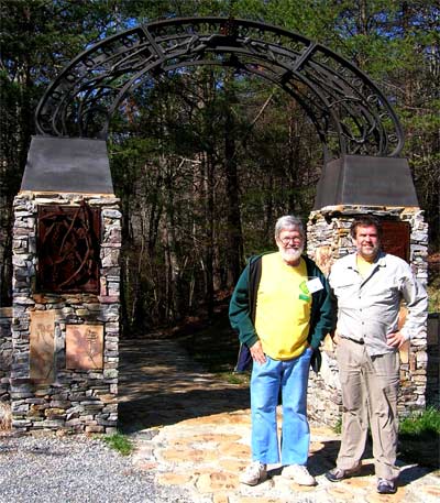
Mother Nature's Son and Me at the Sculpture Gate
Pinhoti Trailhead in Cheaha State Park. circa 2007

Tile at Sculpture Gate at Cheaha State Park

Cheaha State Park, Leaf Gate Trailhead
Tuesday, May 10, 2016

Stairs Northbound from Leaf Gate Trailhead
Cheaha State Park, Scenic Drive Mile 478
June 2017
In fall of 2018, John watched Howard fix these stairs.
Pinhoti Trail Mtce., Cheaha St. Park section south of AL 281 below the park entrance.
May 25, 26, 31, & June 1-3, 2017
I used my Fiskar loppers to trim the woody growth from AL 281 crossing south to the camp site in the broad saddle north of McDill Point. I also picked up trash at the Cheaha TH and a little along the trail and old road that parallels the Pinhoti. One of the RR tie steps on the south side of AL 281 crossing (at MM 478 below the store) needs replacing. Also, there needs to be 2 more signs at the Cave Creek connector trail junction with the Pinhoti. The ice storm and drought will continue to cause hazardous trail conditions in this area. Please consider replacing the existing plastic trash cans with “critter proof” trash cans and / or recycling containers at the Cheaha trailhead. Also, on Monday, June 5th, I spent 2 hours picking up littler along the Bald Rock Board walk trail.
Total time 42 hrs., drive time 14.1 hrs., 818 miles, 1.9 miles of trail cleared. 6+ trips.

Cheaha Water Garden
Pinhoti Trail Mtce, Cheaha State Park sections, Mon., 12/16/13
My long time friend and dedicated trail maintanier, Marion C, drove all the way up from Saraland (near Mobile), AL. And joined me this morning. We parked near the Bald Rock Lodge and hiked in to replace the trail register booklet at the Blue Mt. Shelter. On the way in, we cleared some minor deadfall on the Bald Rock Trail that I'd left on Nov. 29. After a quick lunch (thanks to Emily C), we headed south on the Pinhoti Trail toward McDill Overlook. We cleared the trail all the way to the Wilderness border then took the short cut back north across the old road bed and camp site. The new wilderness sign had already been pulled up and was leaning against a tree.
Total time = 9 hrs., drive time = 2.5 hrs., 139 miles, 2.8 miles of trail cleared.

Bald Rock / Pinhoti Trail Junction
Tuesday, May 10, 2016
Cheaha St. Pk. Trail Mtce., CCC Tower & Reservoir Trails, & north loop bike trail. Sun., 03/02/2014
I met another volunteer named Marvin (from Piedmont, AL) at the Cheaha store and we were told to drive up to the Bald Rock parking area. There we met Mandy P and we followed her back to the camp ground where we started clearing the green blazed trail which leads up to the CCC tower. Funny, I didn't even know this trail existed! I got hung up on several downed trees right at the start while the other 3 guys managed to clear all the way to the top. Next, I worked with Mandy, the Park Naturalist, and a mother/son team (from Muscadine, AL), clearing the new “Pink” blazed trail which takes off the green trail and leads down to the original CCC reservoir.
After lunch, we worked on the bike trail starting at the entrance near the group camp ground. I worked alone the last hour (Mandy had a “Leave-no-trace” meeting to attend) and cleared about half the small north loop just below Bald Rock Lodge.
My total time = 9.8 hours, drive time = 2.5 hours, distance = 139 miles, about 0.5 mile trail cleared.
Pinhoti Trail Mtce., Cheaha State Park section s. of Hwy 281. Mon-Wed., 03/3-/2014
On Monday, I didn't get much work done. I stopped to see the newly opened Lake Chinnabee Recreation Area on my way past Camp Mack, hoping the rain would slack up a bit. It didn't. I parked at the Cheaha Trailhead, put on my fleece jacket and rain coat too then hiked south along the Pinhoti, using my loppers and kicking off small dead limbs. When I got to the spot where the USFS fire crew had stopped clearing last Thursday (about 250 yards south of the gap on the north slope of Hernandez Peak), my gloves and feet were “soaked to the bone” so I decided to head back. I arrived at the parking lot about 11:30am but did not want to go home yet even though the drizzle had finally stopped. I drove northward and after lunch, hiked in to the Lower Shoal Shelter. I did take my loppers as usual and cut several sprouts I'd missed on the previous trip. The shelter log book was missing and I took all the trash out on my return trip.

Blister Bob
February 18, 2014
On Tuesday, I met my good friend Blister Bob at the Cheaha Trail-head parking lot. We hiked in about a mile and started working southward. We certainly earned our paychecks today. We stopped briefly for a snack lunch (Bob had given me some of Dixie's famous cookies earlier and they were burning a hole in my pocket) on the south slope of Hernandez Peak. The whole top was covered in frost; it was beautiful but cold, especially when it started to thaw and drip. When we got to the broad saddle just north of McDill point, we were pretty tired. Fortunately, we ran into a hiker named Bryan L from New Orleans, LA. I recognized his accent immediately and loved listening to him talk. He was an Appalachian Trail through hiker also, having completed it 3 years ago. We decided to hike on out with Bryan and enjoyed more conversation with him all the way back to the parking lot.

Blue Mountain Shelter
Friday, July 29, 2016

CCC Stone Bridge, Old CCC Road to Cheaha State Park
Thursday, June 23, 2016
This road, built by the Civilian Conservation Corps, was known as the Oxford - Cheaha Road and was the original access road to Cheaha State Park. John's mother walked it in the late 1930's. This bridge is east of the Pinhoti along the CCC road and over Hillabee Creek. Another similar bridge is west along the CCC road, also over Hillabee Creek.
Pinhoti trail Mtce., Tue., Dec. 17, 2013. FS589 or Cheaha Rd. n. to Hillabee Creek & Co Rd 24.
Marion & I drove and parked where the CCC Rd. blockades are about 3 miles south of McIntosh Rd. Some one had picked up all the car tires that had been dumped there (along with most of the other garbage too) which I'd reported on Nov. 27. Many Thanks to y'all! We walked in about a half mile where the trail crosses the old Cheaha/Oxford road and headed north. We both used our loppers and cleared the trail all the way to the Hillabee Creek crossing. It took me 1 hr. and 16 minutes to get back to the CCC Rd then 9 more minutes to get back to my car. Marion continued north and cleared 7 more minor dead-falls that had occurred since Hayward W had walked through here on Nov. 2. I arrived at Abel Gap road before Marion did so I walked in and manicured the trail for a few minutes before he met me. It was a long day and we got a lot done.
Total time=10.25 hrs., drive time=2.25 hrs., distance 124 miles, 3+ miles of trail cleared.

Volunteer Marion
Wednesday, July 27, 2016

Marion with his Modified Chainsaw Pack
The aluminum packframe was from John's very first pack.
Sunday, December 14, 2008

Dan Tossing Logs
Wednesday, November 21, 2007
Pinhoti Trail Mtce., Abel Gap Rd(Co Rd 24) south, April 15, 24, & 29th, 2017 I finally picked up the trash near the large downed tree that ATVs had been driving around about 1.5 miles south of Co Rd 24 and also loppered my way from Abel Gap Rd south to the Friendship campsite.
Total Time 19.5 hrs., drive time 6.3 hrs., 364 miles, 0.7 miles of trail cleared, 3 trips.
Pinhoti Trail Mtce., Abel Gap Rd(Co Rd 24) north, April 27,28 & May 8.
I cleared brush from Co Rd 24 north to the narrow canyon just north of the last spur rd. crossing off FS 515. The AOA group had cleared this back I the fall so my loppering went fast and easy. Cousin Phil Martin went with me on May 8th and we saw a large thin black goat right on the trail in front of us down in the narrow draw. I thought it was just a burned stump until it moved and ran off.
Total time 20.5 hrs., drive time 6.9 hours., 342 miles. 1.9 miles of trail cleared. 3 trips.
Pinhoti Trail Mtce. ATCA Section. Sun 06/23/13
I finished clearing the trail from Co24, Abel Gap Rd., north to the switchback near Morgan Lake then moved to FS 518 off the Scenic view drive where I also finished clearing a small part of the trail just south of this crossing. I also touched up the blazes at this crossing. (A sign showing the Morgan Lake Falls trail would be a good idea).

Morgan Lake Map Sign

Todd, Jamie H, John, ?
Tuesday, October 16, 2018

Pinhoti Volunteer Crew: John, Scott, Hayward
Saturday, November 19, 2016,
Pinhoti Mtce. Trip with O Kenny, Tom C, Van P Sat., 05/27/17.
Worked in 4 areas, n. of FS518, S. of I 20, n. of Pine Glen, and n. of FS 523. Tom & Van built benches at camp site n. of FS518.
Total time 10 hrs., drive time 2.3 hrs., 130 miles, 0.1 mile of trail cleared.

Kenny, Tom, and Van's Campsite, Fire Ring, Benches
May 2017

Tire Clean Up, Forest Road 518, Scenic Drive 281

|

|

Wind Storm South of I20

Windstorm Damage South of Interstate Highway 20
 Improper Slash Disposal South of US78 November 9, 2009 |
|
After a company is paid to thin a forest, they are supposed to clear the resulting slash near the trail (~50'), and either cut it so it lays flat and rots away or pile and burn it. Above and below are pictures of cuts trailworkers made through slash left over the Pinhoti Trail.
Dear Lesley, |
 Improper Slash Disposal South of US78 November 9, 2009 |

Blowdown North of I20
Saturday, September 24, 2016

Mothers Day Tornado
Monday, September 26, 2016,
The mother's day tornado of 2008 ripped down a wide swath of trees over the Pinhoti. It took John many work trips to cut the Pinhoti's path through the tangled trees. Today, it is recovering well, with many blackberries and longleaf pines.

Mother's Day Tornado, Pinhoti Trail, near Alabama 281
Monday, September 26, 2016
Sun 06/23/13
I moved again to the trail crossing where the “Mother’s Day Tornado” had also crossed the Scenic drive. I started north using my loppers to clear the spring growth but soon realized I needed my Echo Brush cutter. So, I returned to my car and decided to drive north and clear as much as possible on the trail north of the RR/FS500 trailhead north of US78.
I cleared the 1st mile of trail (including the 0.3 mile between FS500 and the railroad). On the walk back I saw a common King snake with a horned lizard in its mouth. Quite a thrill since it was slithering rapidly right towards me; that is until it saw me, then it spit out the lizard and scurried away as fast as it could. Sorry no picture; it happened so fast.
Total time = 9.5 hrs, drive time = 2.75 hrs., distance = 140 miles, 1.4 miles of trail cleared.

Gas Pipeline View
Sunday, September 11, 2016

?, Keith, Leesha, ?, Durwin
Indian Shelter north of I20
February 8, 2014
Pinhoti Day Hike, Anniston Outdoor Association (AOA) Sat., Feb 8, 2014
It sure was nice to hike instead of work today. The AOA hike was lead by Keith Hudson. We had 7 hikers in all and started hiking south at FS 623. The weather was great and we had a few good views of Mt Cheaha. After lunch at the railroad trail-head, we stopped to examine the Indian Shelter and the small “grinding hole”. The trail was in good condition but there were 3 big logs across it, 1 north of the Indian overhang and 2 south of it, which could be removed. The American Chestnut tree (about .2 mile n. of the AL 281 crossing) is still in good condition. We had a wonderful hike of 6.3 miles: thank you Keith.

Mike, ?, Warren?, Leesha, Durwin
View of Cheaha From North of Railroad
February 8, 2014
Alabama Hiking Trail Society (AHTS) hike, Pinhoti Trail from US Hwy 78 to US Hwy 431, 9.5 miles. About 17 folks participated, including Ken & Roe H, Brandon S, Hayward W...

Ken, Roe, Brandon, Hayward
February 15, 2014

US Highway 78 RR Trailhead
Sunday, June 26, 2016

False Caesars's Mushroom Amanita parcivolvata
July 2013

Umbrella Magnolia
June 2017

Stele: "YCC Crew 5 1977"
Monday, April 10, 2017
Youth Conservation Corps groups built much of the Pinhoti from Coleman Campground to US 78.

Lower Shoal Shelter
Friday, September 4, 2015

Goodies, Lower Shoal Shelter
Tuesday, November 15, 2016

Bridge North of FS531
Wednesday, November 16, 2016

Laurel Shelter
Tuesday, November 24, 2015

Shoal Creek Church
Sunday, October 4, 2015

Sweetwater Lake North Map Sign
Thursday, October 17, 2013

Sweetwater Lake
Saturday, December 3, 2016

Sweetwater Lake Earthen Dam
Tuesday, November 17, 2015

Sweetwater Lake South Map Sign
Thursday, October 17, 2013
Pinhoti Trail, ATCA section, with YCC group. Thurs., 06/27/13, Sweetwater Lake area.
I met Lesley, Mandy P, a group of 7 young Youth Conservation Corps adults, and Michell, with an intern, and a photographer at the USFS Heflin station at 830am. A little after 10 am we hiked around the original high trail around Sweetwater lake and back on the “fisherman’s trail” which stays near the lake shore and often floods in the winter and spring. A few minutes after lunch, we started working on the trail where it crosses FS500-M, the access road to the lake. One crew did side hill digging and raking southward and one crew dug out and installed rock steps. I took lots of pictures, or so I thought. When I got home I tried to pull out the “card” from my camera. It wasn’t there. It was in the computer where I’d left it a few days ago! Sorry about that and also, I didn’t write the names of any one in the group. We got a lot done, perhaps building 3 to 4 hundred yards of trail. Many thanks to all the folks who did that hard work.
My total time = 9 hrs., drive time = 2.3 hrs., distance = 125 miles, 0.1 mile of trail built.

John eats a sign which translates the Cherokee word
Pinhoti as home of the turkey circa 2007

Woodpecker Farm North
Friday, April 15, 2016

Rusty
December 2010
Pinhoti Trail ATCA section,, n. of FS 540
Wednesday, 12/22/10
Rusty W came to our home and we drove north of Coleman Lake and parked where the trail crosses FS540. My ’86 Toyota Truck was slipping and sliding a little due to the recent damp weather but we made it safely all the way up FS500. We headed north hoping to find the “tree across the Pinhoti trail” that was reported in a letter from Noonan P dated May 13, 2010. We used our loppers to clear the annual woody growth as we hiked in. The trail was in good condition. We weren’t sure that the letter didn’t refer to the huge oak tree that I’d seen last year which was south of FS540 (about 0.2 mile in). We passed by several “step over logs” on the way in, planning to remove them on the way out if we deemed necessary About a mile in, we came to the reported blow-down. It was a large oak that had fallen from across the creek and knocked a few smaller trees down in the process. There was a well beaten path around the crown of the tree up against the large rock wall on the east side of the small canyon. The new detour looked so well used that we almost decided to leave it as the official path. I had to go around the tree top and stand in the tread with my orange cap on just so Rusty could barely see me and determine where the old established tread had been. It took a while but we finally cleared the many limbs away and ate lunch. We kept clearing the woody growth northward to the broader valley before turning around and hiking back to my truck. We decided to hike a few hundred yards south just to see if the large oak (which hikers could easily walk under and had been down for at least 2 years) was still there. It was and it was still not a problem for hikers, so we took a few pictures and removed an old hollow log on the way back up to FS540.

John C
Mother Nature's Son
Mister Pinhoti
December 2010
Pinhoti Trail Mtce., ATCA section, s. of I 20 & Coleman TH area, Fri, Sun., 03/29,31/2013
I continued clearing the trail south of I 20. This time I worked from where the trail crosses a newly graveled (but now closed) logging road which used to connect to the Scenic drive about 0.6 mile south of I 20. I worked north along the trail and met 2 hikers, “Jelly Bean” and her friend (“9 Days”), whom we had met 2 years ago on our Pinhoti thru hike attempt. Most of the wind damage in the 1st mile of trail south of I 20 occurred in the two thinned areas on each side of the creek valley which is about a half mile in from the Scenic drive. “Jelly Bean and 9 Days” reported there was no damage south of the graveled log road to FS518. They said there is a large blown down oak tree just south of FS518. They had hiked from US431 and mentioned no damage in that area as well. Within the 1st mile of trail south of I 20 there are at least 16 large trees either across the trail, along it, or leaning over it, that need to be removed. The trail is passable and safe to hike in my opinion. Also, there are some up-rooted damages to the tread-way which might make a good YCC or Scout project.

Rootball and Multiple Trunks over Pinhoti South of Interstate 20
April 2013
I also examined part of the area near Coleman Lake Trailhead. I hiked south from the trail head for about 0.2 mile and saw no damage. I then hiked north of FS500 at the trailhead for about 0.3 mile and saw no damage. I drove around to where the trail crosses FS540 and hiked south for about 0.2 mile. I cleared one minor pine tree off the trail (just south of where the horse trail crosses), otherwise, it looked like no significant damage had occurred here. I then hiked north for about 0.25 mile, kicking off lots of loose limbs as I went. I saw a few uprooted trees out in the woods away from my path but none on the trail. Last night I talked to Dale Thrasher, who said most of the downed trees are along the old roadbed north of the “Twenty Feet Creek” (s. branch of Choccolocco Creek) crossing which would be between 3 to 4 miles north of FS540.
Total Time = 23 hrs., drive time – 5.25 hrs., distance = 276 miles, approx.. 1.2 miles of trail cleared. 2 trips

Coleman Lake Trailhead Day Hikers
Ken and Roe in Orange and Blue
Saturday, February 25, 2017

Sign, Coleman Trailhead
Sunday, October 4, 2015

YCC Rock Steps
Thursday, November 26, 2015

Dan with Sawn Tree
|
Choccolocco Creek Watershed Project Floodwater Retarding Dam Number 2 | |
| Drainage Area | 13,664 Acres |
| Total Storage | 7,190 Acre Feet |
| Water Surface | Area 31 Acres |
| Height of Dam | 66 Feet |
| Volume of Fill | 180,900 Cubic Yards |
|
and Flood Prevention Act by Calhoun County Commisioners Court and Choccolocco Creek Watershed Conservancy District and Calhoun County Soil Conservation District with the Assistance of Soil Conservation Service of the US Department of Agriculture 1968 | |

Choccolocco Shelter
Saturday, December 5, 2015

Tom, Kenny, and Van in Choccolocco Watershed
June 2017
Pinhoti Trail Mtce., w/ AHTS Metro Group, Choccolocco dam area, Sat. 11/01/2014
Hayward & Karen W came and picked me and much gear up at our home at 6:45am and drove us to Pinky Burn's Trailhead, then to the Choccolocco Shelter area. Brandon, Sam, and ? restored several parts of the treadway along the north shore of the lake then worked on parts south of the dam too. Hayward, Karen, Jill & I cleared the brush and several small dead-falls along the north slope then worked southward for perhaps 3/10ths of a mile. Sam reset the signpost near the dam also. We met a family with several children and also a lone south bound young man who got a little confused south of the dam. We need to put 2 sign posts in that area. There's also a lot more clearing to be done in the first 1.5 miles south of the dam. Many thanks to all those who helped today and also to Greg A for his excellent trail status report.
(Other areas that need clearing are: the first mile s. of Chief Ladiga Trail, the nw slope of Oakey Mt., the first 1.7 miles n. of Terrapin Dam, and the first 1.3 miles n. of FS500 n. of Dugger Mt.).
My total time = 10.25 hours, Hayward's drive time = 3.5 hrs, about 0.8 mile of trail cleared.

Rootball Near Choccolocco Reservoir and Shelter
April 2013
Pinhoti Trail Mtce., ATCA section s. of Co Rd 55, Burns TH., Mon-Tue, 04/1-2/ 2013.
I cleared the trail from Rabbittown Rd. south to about 0.2 miles south of the Choccolocco Spillway. Most of the wind damage was during the first 0.3 mile from the highway to the top of the first ridge and also in the “thinned” area just south of the dam. There were also several small burned dead pines that had fallen along the north shore slope. One large pine in that area had up-rooted, severely damaging the tread-way on a steep slope. Also, the sign-post on the north side of the dam is broken (as well as the NRT post on Co Rd 55). I noticed that someone had cleared all the trees along the dirt access road to the dam and that there was, luckily, no damage to the shelter. The first large pine on the south side of the dam which had a blue blaze, had up-rooted as well as several others in that area. The tread-way needs minor restoration in the area and we need to place a few posts to guide the hikers across the dam and into the woods there. I stopped clearing as the trail left the level area and headed along the slope. There at least 5 large trees that are leaning or down that need removing (2 north of the lake and 3 south) but the trail is relatively safe and easy to follow here. I met a father / son team that planned to fish and stay in the shelter and also a trail runner, Lisa (from Michigan). Also, an Eastern Continental Trail hiker, “Princess Doah” (see trail journals.com for 2012), and Blister Bob and Shadow Sue and another friend plan to hike this section and should give a detailed report soon. Total time = 19 hrs., drive time = 5.25 hrs., distance = 302 miles, 1.7 miles of trail cleared, 2 trips.
John C
PS: I won't be available to help until about April 23.

Pinky Burns Barn after Arson Fire, 2011

Drought, Fire Danger, Dugger Trailhead
Rabbittown Road crossing east of Pinky Burn's Place
Sunday, November 20, 2016

Dugger Wilderness Entrance
Rabbittown Road crossing east of Pinky Burn's Place
Monday, November 23, 2015
 Bench Mark")
Dugger Mountain (2,140') Bench Mark
Wednesday, October 14, 2015
Note the spelling correction on the triangulation bench mark above. In local useage, Dugger is sometmes spelled Duggar, perhaps the correct spelling of a local settler.

Emergency Shelter, Dugger Mountain
aturday, February 11, 2017

Climb Through Before
Tuesday, November 1, 2005

Climb Through After
Tuesday, November 1, 2005

North Dugger Shelter
Thursday, December 10, 2015
Hike/camp out with Tom, Van, & Kenny, on Pinhoti from County Road 55 to FS 540, camp at n. Dugger Shelter, 04/22-23/17

Cigarette Butts, Shotgun Packings, and other Litter Picked Up
June 2017

Oakey Mountain, Terrapin Lake
Sunday, December 13, 2015,

Kenny and Tom fix the Oakey Mountain shelter steps
February 24, 2017

Intersection with the Chief Ladiga Trail, circa 2007
The 33 mile Chief Ladiga Trail connects the Pinhoti Trail with Anniston, Alabama, to the West. Eastward, it becomes the Silver Comet Trail in Georgia, and connects to Smyrna, a suburb of Atlanta. There are a few camping areas and towns, and the whole combined length, 94 miles, is paved for easy biking and walking. One could follow it 8 miles west and resupply in Piedmont.

Sign Down Near Paved Chief Ladiga Rail Trail
June 2017

Trail North of Maxwell Gap
Wednesday, May 11, 2016
Pinhoti Trail Mtce. Maxwell Gap (co rd 70) north. April 14, 25, 2017. I cleared brush for the first 0.6 mile north of Maxwell Gap. I’m sure it needs clearing to where I’d stopped at Lanie Creek crossing about 0.8 mile south of US Hwy 278 on April 7th.
Total time 14.7 hrs., drive time 6 hrs., 352 miles, 0.6 mile of trail cleared. 2 trips.
Pinhoti Trail Mtce., Maxwell Gap south to CO Rd. 94. May 1,2,3,&6, 2017. I cleared the brush with my Fiskar Loppers. The sunny section on the south slope of Wilson Ridge needs trimming at least twice each summer.
Total time 31.6 hrs., Drive time 12 hrs., 708 miles, 1.6 miles of trail cleared. 4 trips.

Galax, Lanie Hollow
Galax urceolata
Tuesday, May 3, 2016

Lanie Creek Dam
Very High Stream Flow
Saturday, December 26, 2015

Lanie Gap Sign
Wednesday, May 11, 2016

Mountain Laurel, Lanie Hollow
Tuesday, May 3, 2016

N Tree, Lanie Hollow
Tuesday, May 3, 2016

US 278 Sign
Thursday, January 14, 2016

Furgerson Plaque
Monday, May 9, 2016
PINHOTI TRAIL
The easement for this 1500 feet of the Pinhoti Trail was donated by
Audrey A. Fergerson in loving memory of her husband Robert R. Furgerson
September 1993

Gerald Willis Memorial Plaque
Thursday, January 14, 2016
The Pinhoti Trail from here to the Georgia Line was built and is maintained by the Alabama Trails Association on an easement donated by the Gerald Willis family of Piedmont, Alabama and on land purchased by the Alabama Forever Wild Land Trust.
October 19, 2002
In 2002 John, Caroll W, and Joe C installed this plaque. ? died fall 2017?

Davis Mountain

Davis Mountain Shelter AOA Hike
 Hurricane Creek Bridge at Flood Stage Saturday, December 26, 2015 |
| The above photo is of the third Hurricane Creek Bridge. The first was a simple rock hop. The second was a suspension bridge. On the south side, there was not enough space from the trail to a dirt road, so the guy lines were short. A flood pushed the suspension bridge to lean downstream and become structurally deficient and unuseable. |

Salem Church Road Looking South
January 2013
Pinhoti Trail Mtce., ATA section. Tue. 01/29/13. Hunt Club Rd to 1700 Ft. Overlook
I decided to park near the Salem Church and take a short cut up the Hunt Club Trail to where I’d cleared on Jan. 8. It is a long steep climb up to the trail but very scenic as one comes close to the trail crossing. I used my loppers to thoroughly clear the trail all the way to the 1700’ Look-out. After a late lunch I walked in to see the progress on the new shelter. WOW. They got all the siding up. It looks great. I still have to clear about 2.8 miles of trail between the overlook and Spring Creek Shelter.
Total time = 10.25 hrs., drive time = 3.5 hrs., 187 miles., 1.3 miles of trail cleared.
John
SITE OF BLUFFTON North and south of Salem Church Road, the Pinhoti travels through recovering iron mine lands. The forest is fairly mature, but there are endless trenches, piles of spoil, and roads through the woods. |

Hawkins Hollow Taj Mahal Shelter
January 2013

Hawkins Hollow Shelter
Thursday, May 5, 2016

Flag Pole Mountain View

Spring Creek Shelter
Monday, May 16, 2016
 Spring Creek Shelter Log: | |
|
1-12-13 I am Almost home. -ALABAMA (ME-AL) [7-19-12-(???)] -"I find letters signed by god on every path + doorstep - and I leave them be - And I tell you, Christine, to be not curious about god" - Walt Whitman (paraphrased)(to a german tourist) (:, [from Song of myself] |
1/13/13 Good to see Alabama's message - I enjoyed meeting him a lot! I am on a 5 week winter hike on the AT, BMT and Pinhoti. I did not expect to hike in 72F heat though - but I've had plenty of snow earlier, too. The shelter came in very handy for the torrential downpour last night. German Tourist aka Christine |

German Tourist
Wednesday, December 19, 2012
German Tourist has hiked the Appalachian, Continental Divide,
and Pacific Crest Trails, collectively known as the Triple Crown,
and paddled the length of the Missouri and Mississippi Rivers.

Spring Creek Shelter Log:
January 25
Thank you Pinhoti! Now onto the unknown...
Someday
Great Eastern Trail
gethiking.net
January 2013
Pinhoti Trail Mtce., ATA section. Mon. 01/28/13. Old Jackson Chapel Rd to Spring Creek Shelter.
I thoroughly loppered the trail from Old Jackson Chapel Rd to the Spring Creek Shelter. There were no big blow-downs and I met a couple riding horses along the way. The weather was great and I ate a late lunch at the shelter. I saw where German Tourist, Jo Someday, and “Alabama” had signed the tiny trail register.
Total time = 10 hrs, drive time = 4 hrs., 213 miles, 1.1 miles of trail cleared.
 Old Jackson Chapel Road, Great Eastern Trail Blazes, Signage Monday, May 16, 2016 The Pinhoti Trail is a link in several long north south routes. For both the Eastern Continental Trail and the International Appalachian Trail, the Pinhoti connects the Florida Trail to the Appalachian Trail (Florida Trail-Alabama Trail in Conecuh NF-Road Walks-Pinhoti Trail-Benton MacKaye Trail-AT). The Great Eastern Trail connects through Georgia and Tennessee (Pinhoti-Roads-Tennessee Cumberland Trail). |

Map of Southeast Trails
Tennessee
Alabama Georgia
| Yellow | Pinhoti |
| Azure | Great Eastern |
| Orange | Benton MacKaye |
| Violet | Appalachian |
| Blue | Bartram |

Jackson Chapel Road
January 2013

Cave Springs Painting

Waterfall off the Georgia Pinhoti in James H."Sloppy" Floyd State Park

